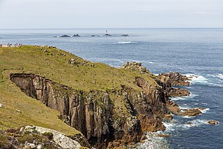
Land's End is a headland and tourist and holiday complex in western Cornwall, England, United Kingdom, on the Penwith peninsula about eight miles (13 km) west-south-west of Penzance at the western end of the A30 road. To the east of it is the English Channel, and to the west the Celtic Sea.

The South West Coast Path is England's longest waymarked long-distance footpath and a National Trail. It stretches for 630 miles (1,014 km), running from Minehead in Somerset, along the coasts of Devon and Cornwall, to Poole Harbour in Dorset. Because it rises and falls with every river mouth, it is also one of the more challenging trails. The total height climbed has been calculated to be 114,931 ft (35,031 m), almost four times the height of Mount Everest. It has been voted 'Britain's Best Walking route' twice in a row by readers of The Ramblers' Walk magazine, and regularly features in lists of the world's best walks.
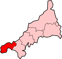
Penwith is an area of Cornwall, England, located on the peninsula of the same name. It is also the name of a former local government district, whose council was based in Penzance. The area is named after one of the ancient administrative hundreds of Cornwall which derives from two Cornish words, penn meaning 'headland' and wydh meaning 'at the end'.

Porthcurno is a small village covering a small valley and beach on the south coast of Cornwall, England in the United Kingdom. It is the main settlement in a civil and an ecclesiastical parish, both named St Levan, which comprise Porthcurno, diminutive St Levan itself, Trethewey and Treen.

Mount's Bay is a bay on the English Channel coast of Cornwall, England, stretching from the Lizard Point to Gwennap Head. In the north of the bay, near Marazion, is St Michael's Mount; the origin of name of the bay. In summer, it is a generally benign natural harbour. However, in winter, onshore gales present maritime risks, particularly for sailing ships. There are more than 150 known wrecks from the nineteenth century in the area. The eastern side of the bay centred around Marazion and St Michael's Mount was designated as a Marine Conservation Zone in January 2016.

Treen is a small village in the parish of St Levan, in the far west of Cornwall, England, United Kingdom. It is about 3 miles (4.8 km) inland from Land's End on a short unclassified spur road from the B3315. Treen overlooks the Penberth Valley and sits about 1 kilometre (0.62 mi) inland from Treryn Dinas, an Iron Age promontory fort, or cliff castle, with five lines of fortification. On the headland is the Logan Rock and to the west is Pedn Vounder tidal beach, which is popular with naturists. Treen Cliff is to either side of Treryn Dinas. The village has a popular pub, The Logan Rock Inn, a village shop, cafe and campsite with views to both Logan Rock and nearby Porthcurno.

St Levan is a civil parish in Cornwall, England, United Kingdom. The parish is rural with a number of hamlets of varying size with Porthcurno probably being the best known. Hewn out of the cliff at Minack Point and overlooking the sea to the Logan Rock is the open-air Minack Theatre, the inspiration of Rowena Cade in the early 1930s.

The Logan Rock near the village of Treen in Cornwall, Britain, UK, is an example of a logan or rocking stone. Although it weighs some 80 tons, it was dislodged in 1824 by a group of British seamen, intent on showing what the Navy could do. However following complaints from local residents for whom the rock had become a tourist attraction and source of income, the seamen were forced to restore it. Today the Logan Rock still rocks, but with much less ease than it did in the past. The South West Coast Path, which follows the coast of south-west England from Somerset to Dorset passes by on the cliffs to the north.

Sennen Cove is a small coastal village in the parish of Sennen in Cornwall, England, United Kingdom. According to the Penwith District Council, the population of this settlement was estimated at 180 persons in 2000. The South West Coast Path passes through Sennen Cove.

Nanjizal, also known as Mill Bay, is a beach and cove in the civil parish of St Levan, Cornwall, on the south-western coast of Great Britain. Situated one mile to the south-east of Land's End, Nanjizal has no direct access via road, and is usually reached via the South West Coast Path from Land's End in the north, or from Porthgwarra to the south. Nanjizal is also a noted bird watching location.

Whitesand Bay is a wide sandy bay near Land's End in west Cornwall, England, United Kingdom. It stretches for one mile between the headlands of Pedn-mên-du and Aire Point. and contains the village of Sennen Cove. It is also a landing point for the Atlantic Crossing 1 international telecommunications cable.

Gurnard's Head is a prominent headland on the north coast of the Penwith peninsula in Cornwall, England. The name is supposed to reflect that the rocky peninsula resembles the head of the gurnard fish.
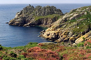
Treryn Dinas is a headland near Treen, on the Penwith peninsula between Penberth Cove and Porthcurno in Cornwall, England.

Gwennap Head is a headland on the south coast of the Penwith peninsula, Cornwall, United Kingdom. It is within the parish of St Levan and approximately 4 miles (6.4 km) south of Land's End, and less than 1 mile (1.6 km) north-west of Porthgwarra, the nearest village. The area of Gwennap Head is designated as part of the Penwith Heritage Coast and also designated as part of the Cornwall Area of Outstanding Natural Beauty. The South West Coast Path closely follows the coastline around the headland.

St Ives Bay is a bay on the Atlantic coast of north-west Cornwall, England, United Kingdom. It is in the form of a shallow crescent, some 4 miles or 6 km across, between St Ives in the west and Godrevy Head in the east.

Treen Cliff is a Site of Special Scientific Interest (SSSI) located on the Penwith Peninsula in Cornwall, England, UK, 6 miles (9.7 km) south-west of Penzance. First notified in 1951, with a revision in 1973, and a further notification on 1 July 1986, it is 49.3 hectares in area, stretching from grid reference SW387220 to SW402225. Designated for both for its biological and geological interest, part of the site, Treryn Dinas, is a Scheduled Ancient Monument consisting of a "cliff castle" with four ramparts and ditches and the Logan Rock. It is within the Cornwall Area of Outstanding Natural Beauty (AONB), the Penwith Heritage Coast and is part owned and managed by the National Trust.

Zennor Head ; is a 750-metre (2,460 ft) long promontory on the Cornish coast of England, between Pendour Cove and Porthzennor Cove. Facing the Atlantic Ocean, it lies 1 kilometre north-west of the village of Zennor and 1.6 kilometres east of the next promontory, Gurnard's Head. The granite (Killas) cliffs rise over 200 feet (60 m) from the sea and the highest point of the headland is 314 feet (96 m) above sea level, with an Ordnance Survey triangulation station. Zennor Head is on the South West Coast Path, which follows the cliff edge closely, skirting the entire perimeter of the headland. The promontory is part of the Penwith Heritage Coast, and is the largest coastal feature in the United Kingdom that begins with the letter "Z". It gets its name from a local saint, Senara. Zennor Head was mined for copper and tin in the Victorian Era. There is no longer any residential or commercial occupancy on the headland, but it is occupied by a variety of coastal animals and plants, such as kestrels and gorse.
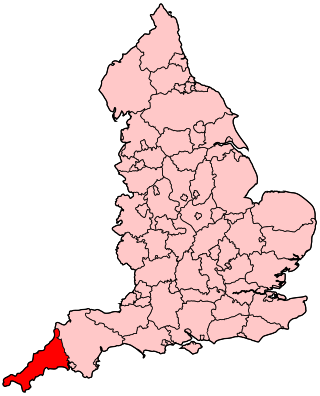
The following outline is provided as an overview of and topical guide to Cornwall: Cornwall – ceremonial county and unitary authority area of England within the United Kingdom. Cornwall is a peninsula bordered to the north and west by the Celtic Sea, to the south by the English Channel, and to the east by the county of Devon, over the River Tamar. Cornwall is also a royal duchy of the United Kingdom. It has an estimated population of half a million and it has its own distinctive history and culture.
Presented below is an alphabetical index of articles related to Cornwall:


