Peever Flats, South Dakota | |
|---|---|
 Peever Flats  Peever Flats | |
| Coordinates: 45°31′23″N96°56′11″W / 45.52306°N 96.93639°W | |
| Country | United States |
| State | South Dakota |
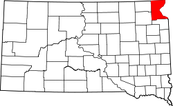
| County | Roberts |
| Area | |
• Total | 0.073 sq mi (0.19 km2) |
| • Land | 0.073 sq mi (0.19 km2) |
| • Water | 0 sq mi (0.00 km2) |
| Elevation | 1,227 ft (374 m) |
| Population | |
• Total | 129 |
| • Density | 1,726.0/sq mi (666.42/km2) |
| Time zone | UTC-6 (Central (CST)) |
| • Summer (DST) | UTC-5 (CDT) |
| ZIP Code | 57257 (Peever) |
| Area code | 605 |
| FIPS code | 46-48948 |
| GNIS feature ID | 2813057 [3] |
Peever Flats is an unincorporated community and census-designated place (CDP) in Roberts County, South Dakota, United States, within the Lake Traverse Indian Reservation. It was first listed as a CDP prior to the 2020 census. [3] The population of the CDP was 129 at the 2020 census. [4]
It is in the east-central part of the county, 2 miles (3 km) southeast of the town of Peever.