White Rock Colony, South Dakota | |
|---|---|
 White Rock Colony  White Rock Colony | |
| Coordinates: 45°54′34″N96°37′30″W / 45.90944°N 96.62500°W | |
| Country | United States |
| State | South Dakota |
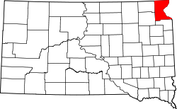
| County | Roberts |
| Area | |
• Total | 0.58 sq mi (1.51 km2) |
| • Land | 0.58 sq mi (1.49 km2) |
| • Water | 0.0077 sq mi (0.02 km2) |
| Elevation | 1,023 ft (312 m) |
| Population | |
• Total | 0 |
| • Density | 0/sq mi (0/km2) |
| Time zone | UTC-6 (Central (CST)) |
| • Summer (DST) | UTC-5 (CDT) |
| ZIP Code | 57260 (Rosholt) |
| Area code | 605 |
| FIPS code | 46-71440 |
| GNIS feature ID | 2807117 [3] |
White Rock Colony is a census-designated place (CDP) and Hutterite colony [4] in Roberts County, South Dakota, United States, partly within the Lake Traverse Indian Reservation. It was first listed as a CDP prior to the 2020 census. [3] The population of the CDP was 0 at the 2020 census. [5]
It is in the northeast corner of the county (and the state of South Dakota), on high ground to the west of the valley of the Bois de Sioux River. South Dakota Highway 127 runs along the eastern edge of the CDP, leading south and west 8 miles (13 km) to Rosholt and north (as North Dakota Highway 127) 8 miles (13 km) to Fairmount, North Dakota. The town of White Rock (population 6 in 2020) is 3 miles (5 km) to the east.