Summit, South Dakota | |
---|---|
![]() Location in Roberts County and the state of South Dakota | |
Coordinates: 45°18′20″N97°02′21″W / 45.30556°N 97.03917°W | |
Country | United States |
State | South Dakota |
County | Roberts |
Incorporated | 1897 [1] |
Area | |
• Total | 0.55 sq mi (1.42 km2) |
• Land | 0.55 sq mi (1.42 km2) |
• Water | 0.00 sq mi (0.00 km2) |
Elevation | 2,015 ft (614 m) |
Population | |
• Total | 288 |
• Density | 525.55/sq mi (202.97/km2) |
Time zone | UTC-6 (Central (CST)) |
• Summer (DST) | UTC-5 (CDT) |
ZIP code | 57266 |
Area code | 605 |
FIPS code | 46-62220 [5] |
GNIS feature ID | 1267597 [3] |
Summit is a town in Roberts County, South Dakota, United States. The population was 288 at the 2020 census. [6]
Summit was laid out in 1892, and was so named on account of the town site's lofty elevation. [7]
According to the United States Census Bureau, the town has a total area of 0.56 square miles (1.45 km2), all land. [8]
Summit has a warm-summer humid continental climate (Dfb) according to the Köppen–Geiger climate classification system and a temperate continental climate (Dc) according to the Trewartha climate classification system, with (as its classification indicates) warm, rainy summers and generally sub-freezing, dry winters.
Climate data for Summit 1 W, South Dakota (1991−2020 normals, extremes 1956−present) | |||||||||||||
---|---|---|---|---|---|---|---|---|---|---|---|---|---|
Month | Jan | Feb | Mar | Apr | May | Jun | Jul | Aug | Sep | Oct | Nov | Dec | Year |
Record high °F (°C) | 64 (18) | 62 (17) | 81 (27) | 94 (34) | 95 (35) | 103 (39) | 103 (39) | 102 (39) | 97 (36) | 88 (31) | 76 (24) | 57 (14) | 103 (39) |
Mean daily maximum °F (°C) | 20.7 (−6.3) | 25.7 (−3.5) | 38.7 (3.7) | 54.6 (12.6) | 68.2 (20.1) | 77.1 (25.1) | 81.9 (27.7) | 80.4 (26.9) | 73.0 (22.8) | 57.5 (14.2) | 39.8 (4.3) | 25.7 (−3.5) | 53.6 (12.0) |
Daily mean °F (°C) | 11.4 (−11.4) | 15.9 (−8.9) | 28.5 (−1.9) | 42.5 (5.8) | 55.5 (13.1) | 65.3 (18.5) | 70.0 (21.1) | 68.3 (20.2) | 60.5 (15.8) | 45.9 (7.7) | 30.3 (−0.9) | 17.2 (−8.2) | 42.6 (5.9) |
Mean daily minimum °F (°C) | 2.1 (−16.6) | 6.1 (−14.4) | 18.4 (−7.6) | 30.3 (−0.9) | 42.8 (6.0) | 53.5 (11.9) | 58.1 (14.5) | 56.3 (13.5) | 47.9 (8.8) | 34.4 (1.3) | 20.7 (−6.3) | 8.6 (−13.0) | 31.6 (−0.2) |
Record low °F (°C) | −38 (−39) | −40 (−40) | −26 (−32) | −7 (−22) | 15 (−9) | 30 (−1) | 38 (3) | 32 (0) | 15 (−9) | 4 (−16) | −25 (−32) | −34 (−37) | −40 (−40) |
Average precipitation inches (mm) | 0.65 (17) | 0.69 (18) | 1.03 (26) | 2.34 (59) | 3.16 (80) | 3.95 (100) | 4.07 (103) | 2.97 (75) | 2.77 (70) | 2.51 (64) | 0.90 (23) | 0.66 (17) | 25.70 (653) |
Average snowfall inches (cm) | 10.2 (26) | 12.4 (31) | 8.8 (22) | 7.8 (20) | 0.1 (0.25) | 0.0 (0.0) | 0.0 (0.0) | 0.0 (0.0) | 0.0 (0.0) | 2.0 (5.1) | 5.4 (14) | 11.9 (30) | 58.6 (149) |
Average precipitation days (≥ 0.01 in) | 6.3 | 5.8 | 5.9 | 7.5 | 10.7 | 11.2 | 9.1 | 8.5 | 8.2 | 7.8 | 5.1 | 6.7 | 92.8 |
Average snowy days (≥ 0.1 in) | 5.2 | 4.8 | 3.2 | 2.2 | 0.1 | 0.0 | 0.0 | 0.0 | 0.0 | 0.8 | 2.8 | 5.2 | 24.3 |
Source: NOAA [9] [10] |
Census | Pop. | Note | %± |
---|---|---|---|
1900 | 237 | — | |
1910 | 545 | 130.0% | |
1920 | 556 | 2.0% | |
1930 | 431 | −22.5% | |
1940 | 459 | 6.5% | |
1950 | 431 | −6.1% | |
1960 | 283 | −34.3% | |
1970 | 332 | 17.3% | |
1980 | 290 | −12.7% | |
1990 | 267 | −7.9% | |
2000 | 281 | 5.2% | |
2010 | 288 | 2.5% | |
2020 | 288 | 0.0% | |
U.S. Decennial Census [11] [4] |
As of the census [12] of 2010, there were 288 people, 112 households, and 69 families residing in the town. The population density was 514.3 inhabitants per square mile (198.6/km2). There were 129 housing units at an average density of 230.4 per square mile (89.0/km2). The racial makeup of the town was 63.5% White, 0.3% African American, 29.2% Native American, 0.3% Asian, and 6.6% from two or more races. Hispanic or Latino of any race were 1.0% of the population.
There were 112 households, of which 42.9% had children under the age of 18 living with them, 40.2% were married couples living together, 10.7% had a female householder with no husband present, 10.7% had a male householder with no wife present, and 38.4% were non-families. 33.0% of all households were made up of individuals, and 9% had someone living alone who was 65 years of age or older. The average household size was 2.57 and the average family size was 3.32.
The median age in the town was 32.5 years. 35.4% of residents were under the age of 18; 6.6% were between the ages of 18 and 24; 25% were from 25 to 44; 23.3% were from 45 to 64; and 9.7% were 65 years of age or older. The gender makeup of the town was 53.1% male and 46.9% female.
As of the census [5] of 2000, there were 281 people, 119 households, and 74 families residing in the town. The population density was 747.2 inhabitants per square mile (288.5/km2). There were 144 housing units at an average density of 382.9 per square mile (147.8/km2). The racial makeup of the town was 83.63% White, 14.23% Native American, and 2.14% from two or more races.
There were 119 households, out of which 31.1% had children under the age of 18 living with them, 44.5% were married couples living together, 13.4% had a female householder with no husband present, and 37.0% were non-families. 31.9% of all households were made up of individuals, and 16.8% had someone living alone who was 65 years of age or older. The average household size was 2.36 and the average family size was 3.01.
In the town, the population was spread out, with 30.6% under the age of 18, 6.8% from 18 to 24, 24.6% from 25 to 44, 18.5% from 45 to 64, and 19.6% who were 65 years of age or older. The median age was 36 years. For every 100 females, there were 97.9 males. For every 100 females age 18 and over, there were 91.2 males.
The median income for a household in the town was $18,875, and the median income for a family was $23,125. Males had a median income of $28,750 versus $17,750 for females. The per capita income for the town was $9,339. About 28.2% of families and 34.9% of the population were below the poverty line, including 37.9% of those under the age of eighteen and 50.9% of those 65 or over.
Saint John's Lutheran Church is a Christian church of the Wisconsin Evangelical Lutheran Synod in Summit. [13] [14]
Intercity bus service to the town is provided by Jefferson Lines. [15]
Hettinger is a city in and the county seat of Adams County, North Dakota, United States. The population was 1,074 at the 2020 census.
Willow City is a city in Bottineau County, North Dakota, United States. The population was 149 at the 2020 census.
Towner is a city in McHenry County, North Dakota. It is the county seat of McHenry County. The population was 479 at the time of the 2020 census. It is part of the Minot Micropolitan Statistical Area. Towner was founded in 1886.
Upham is a city in McHenry County, North Dakota, United States. The population was 135 at the 2020 census. It is part of the Minot Micropolitan Statistical Area. Upham was founded in 1905.
Tyndall is a city in and the county seat of Bon Homme County, South Dakota, United States. The population was 1,057 at the 2020 census.
Columbia is an incorporated small town on the James River in Brown County, South Dakota, United States. The population was 160 at the 2020 census. There is a large granary co-op at Columbia, also a post office, a bank, a bar, a church, a town park, and a community center, in addition to the city hall; and many homes.
Pukwana is a town in Brule County, South Dakota, United States. The population was 233 at the 2020 census.
Pickstown is a town in southern Charles Mix County, South Dakota, United States. The population was 230 at the 2020 census. It was named after U.S. Army General Lewis A. Pick, former director of the Missouri River Office of the United States Army Corps of Engineers.
Wagner is a city in Charles Mix County, South Dakota, United States. The population was 1,490 at the 2020 census. The city is served by Wagner Municipal Airport as well as YST Transit buses.
Garden City is a town in Clark County, South Dakota, United States. The population was 33 at the 2020 census.
Armour is a city in county seat of Douglas County, South Dakota, United States. The population was 698 at the 2020 census.
Gregory is a city in western Gregory County, South Dakota, United States. The population was 1,221 at the 2020 census.
Camp Crook is an incorporated small town in Harding County, South Dakota, United States, on the Little Missouri River. The population was 60 at the 2020 census.
Parkston is a city in Hutchinson County, South Dakota, United States. The population was 1,567 at the 2020 census.
Cottonwood is a small rural hamlet in Jackson County, South Dakota, United States. The population was 12 at the 2020 census. There are no businesses or services at Cottonwood.
Kadoka is a city in, and the county seat of, Jackson County, South Dakota, United States. The population was 543 at the 2020 census. The town occupies about 2.3 square miles.
Murdo is a city in and county seat of Jones County, South Dakota, United States. The population was 475 at the 2020 census.
Wasta(Lakota: wašté) is a town in Pennington County, South Dakota, United States, situated along the Cheyenne River. It had a population of 65 at the 2020 census.
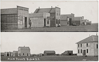
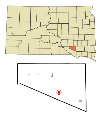
Bison is a town in and the county seat of Perkins County, South Dakota, United States. The population was 302 at the 2020 census.
Enderlin is a city in Cass and Ransom counties in the State of North Dakota. The population was 881 at the 2020 census.