Agency Village, South Dakota | |
|---|---|
 Tiospa Zina Tribal School, located in Agency Village | |
 Agency Village  Agency Village | |
| Coordinates: 45°34′47″N97°04′42″W / 45.57972°N 97.07833°W | |
| Country | United States |
| State | South Dakota |
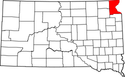
| County | Roberts |
| Area | |
• Total | 7.17 sq mi (18.57 km2) |
| • Land | 7.15 sq mi (18.52 km2) |
| • Water | 0.02 sq mi (0.05 km2) |
| Elevation | 1,545 ft (471 m) |
| Population | |
• Total | 776 |
| • Density | 108.50/sq mi (41.89/km2) |
| Time zone | UTC-6 (Central (CST)) |
| • Summer (DST) | UTC-5 (CDT) |
| ZIP code | 57262 |
| Area code | 605 |
| FIPS code | 46-00520 [4] |
| GNIS feature ID | 2584542 [2] |
Agency Village is an unincorporated area and census-designated place (CDP) in Roberts County, South Dakota, United States. It is the headquarters of the Sisseton Wahpeton Oyate and home to Sisseton Wahpeton College. [5] Since 2020, the CDP includes the community known as Goodwill. The population of the CDP was 776 at the 2020 census. [6]
Contents
The village hosts a number of powwows, one of which is held annually just before Independence Day. This outdoor powwow draws a large number of tourists to the area. The community is primarily made up of members of the tribe.