
Pengold is a hamlet near St Gennys in Cornwall, England, UK. [1] Pengold is southwest of Higher Crackington. [2]
Pengold is a hamlet near St Gennys in Cornwall, England, UK. [1] Pengold is southwest of Higher Crackington. [2]
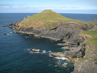
The Rumps is a twin-headland promontory at the north-east corner of Pentire Head in north Cornwall, United Kingdom.

Cutler Heights is a locality between Bowling and Laisterdyke in Bradford, West Yorkshire, England. It is known for its many industrial estates, among them engineering and steel trading businesses.

The River Inny is a small river in east Cornwall, United Kingdom. It is a tributary of the River Tamar and is about twenty miles (32 km) long from its source near Davidstow on the eastern flank of Bodmin Moor to its confluence with the Tamar at Inny Foot near Dunterton.
Deviock is a coastal civil parish in south-east Cornwall, England, United Kingdom. It is situated approximately three miles (5 km) west of St Germans and straddles the valley of the River Seaton. The parish includes the settlements of Hessenford, Seaton and Downderry and the population in the 2001 census was 1341, increasing to 1,420 at the 2011 census. The parish occupies an area of 2,108 hectares.

The River Allen in north Cornwall is one of two rivers in Cornwall which share this name. In this case the name is the result of a mistake made in 1888 by Ordnance Survey, replacing the name Layne with Allen which is the old name for the lower reaches of the Camel. The other River Allen runs through Truro.

The De Lank River is a small river in north Cornwall, England. It is a tributary of the River Camel and is approximately nine miles (14.5 km) long from its source on Bodmin Moor to its confluence with the Camel two miles (3 km) south of St Breward.
Bradford is a hamlet in the county of Cornwall, England, UK, 10.3 km north-northeast of the town of Bodmin, north of the A30 road. Bradford is in the valley of the De Lank River on Bodmin Moor. According to the Post Office the 2011 census population was included in the civil parish of Blisland.
Bottoms is a hamlet in west Cornwall, England, UK. It is located within the civil parish of St Levan, 5 miles (8.0 km) south-west of the town of Penzance. The hamlet of Trebehor lies further west. It contains St Levan CP School, St Levan's community primary school.

Calloose is a hamlet near Leedstown in west Cornwall, England, UK.

Carkeel is a hamlet north of Saltash in southeast Cornwall, England.

Helebridge is a hamlet west of Marhamchurch in northeast Cornwall, England.
Herniss is a hamlet in the civil parish of Mabe in west Cornwall, England. Herniss is on the A394 main road. It is in the civil parish of Stithians

Hersham is a hamlet south of Kilkhampton in Cornwall, England. Hersham is near Grimscott. It is in the civil parish of Launcells.

Northcott is a hamlet in Cornwall, England. Northcott is north of Bude and on the coast close to Northcott Mouth.

Pencuke is a hamlet near Higher Crackington in northeast Cornwall, England, UK.

Penhallick is a hamlet near Pool in Cornwall, England, UK. Penhallick House was built in 1892 by Richard Cowlin the local miller and grocer who owned Cowlin Mill. The mill was converted in the 1980s by Kerrier Groundwork and was offices for Cornwall Council. The mill building is currently for sale with potential change of use to residential.
Rosecare is a hamlet in the parish of St Gennys, Cornwall, England. Rosecare is east of Higher Crackington.
St Ann's Chapel is a hamlet in the parish of Calstock, Cornwall, England, United Kingdom. It is west of Gunnislake on the A390 between Tavistock and Liskeard.
Treskinnick Cross is a hamlet at Grid ref. SX2098 on the A39 main road near Poundstock in northeast Cornwall, England, United Kingdom.

The River Kensey is a river in east Cornwall, England, UK which is a tributary of the River Tamar.
| Unitary authorities | |
|---|---|
| Major settlements |
|
| Rivers | |
| Topics | |
Coordinates: 50°43′08″N4°38′28″W / 50.719°N 4.641°W
| | This Cornwall location article is a stub. You can help Wikipedia by expanding it. |