
Penhalvean (Cornish : Pennhal Vian) [1] is a hamlet in the civil parish of Stithians in Cornwall, England, UK. [2] [3]
Penhalvean (Cornish : Pennhal Vian) [1] is a hamlet in the civil parish of Stithians in Cornwall, England, UK. [2] [3]

Polyphant, recorded as Polefant c. 1170, is a village in east Cornwall, England, United Kingdom. It is north of the civil parish of Lewannick, five miles (8 km) west of the town of Launceston near the convergence of the River Inny and Penpont Water.
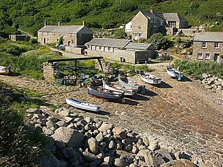
Penberth is a valley, coastal village and cove on the Penwith peninsula in Cornwall, England. It is approximately 7 miles (11 km) southwest of Penzance. Most of the village is within the parish of St Buryan and the boundary with St Levan follows the Penberth river.

Ruthvoes is a village in mid Cornwall, England, United Kingdom. It is in the parish of St Columb Major, about two miles (3 km) south of St Columb Major town and 6+1⁄2 miles (10.5 km) east of Newquay.

Manaccan is a civil parish and village on the Lizard peninsula in south Cornwall, United Kingdom. The village is about five miles (8 km) south-southwest of Falmouth.

St Michael Caerhays is a civil parish and village in Cornwall, England, United Kingdom. The village is about seven miles (11 km) south-southwest of St Austell. The population as of the 2011 census was 96

Phillack is a village in west Cornwall, England, United Kingdom. It is about one mile (1.6 km) northeast of Hayle and half-a-mile (0.8 km) inland from St Ives Bay on Cornwall's Atlantic ocean coast. The village is separated from the sea by a range of high sand dunes known as The Towans.

Newbridge is a hamlet in the civil parish of Madron on the Penwith peninsula in west Cornwall, England, United Kingdom. It is on the A3071 road between St Just and Penzance, about three miles (5 km) west of the latter.

Boscoppa is a settlement in the amalgamation of St Austell in Cornwall, England, United Kingdom. Originally Boscoppa was a separate village but is now a suburb of St Austell and is west of the recently built A391 bypass road. The village lies in a former mining area.

Holywell is a coastal village in north Cornwall, England, United Kingdom. It is at Holywell Bay, about three miles (5 km) west-southwest of Newquay.

Caradon Hill is on Bodmin Moor in the former Caradon district of Cornwall, England, United Kingdom. The summit is 371 metres (1,217 ft) above mean sea level. Caradon Hill is on the southeastern edge of the moor; it is between the villages of Minions (northwest), Upton Cross (northeast), Pensilva (southeast) and Darite (southwest).
Goonhavern is a village in north Cornwall, England. It is on the A3075 Newquay to Chiverton Cross road, about two miles east of Perranporth. It is in the civil parish of Perranzabuloe
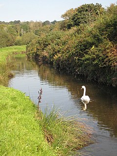
The River Cober is a short river in west Cornwall, England, United Kingdom. The river runs to the west of Helston into The Loe, Cornwall's largest natural lake.

The River Ottery is a small river in northeast Cornwall, United Kingdom. The river is about twenty miles (32 km) long from its source southeast of Otterham to its confluence with the River Tamar at Nether Bridge, two miles (3.2 km) northeast of Launceston.

Carlyon is one of four new civil parishes created on 1 April 2009 for the St Austell area of south Cornwall, England, United Kingdom.

Portscatho is a coastal village on the Roseland Peninsula in Cornwall, England, United Kingdom. The village adjoins Gerrans on the east side of the peninsula, about seven miles (11 km) south-southeast of Truro. It has an estimated population of 1,500 people.

Calenick is a hamlet in the civil parish of Kea, about a mile south of Truro in Cornwall, England, UK. It is at the head of Calenick Creek, which opens into the River Truro near Sunny Corner.

Garras is a village in the parish of Mawgan-in-Meneage, in west Cornwall, England, UK.

Kehelland is a hamlet northwest of Camborne in west Cornwall, England.

Langore is a village in Cornwall, England. It is in the parish of St Stephens by Launceston Rural and is about halfway between St Stephens and Egloskerry.
Pengegon is a residential area east of Camborne, Cornwall, England, which has a fish and chip shop, a playground and memorial to local teen Shakira Pellow. From 2013 to 2021, Pengegon was included in the Camborne Treslothan division on Cornwall Council. After boundary changes at the 2021 local elections, it was placed in the new Four Lanes, Beacon and Troon division.
| Unitary authorities | |
|---|---|
| Major settlements |
|
| Rivers | |
| Topics | |
Coordinates: 50°11′37″N5°12′37″W / 50.1936974°N 5.210311°W
| | This Cornwall location article is a stub. You can help Wikipedia by expanding it. |