
Union County is a county located in the U.S. state of Ohio. As of the 2020 census, the population was 62,784. Its county seat is Marysville. Its name is reflective of its origins, being the union of portions of Franklin, Delaware, Madison, and Logan counties. Union County is part of the Columbus, Ohio Metropolitan Statistical Area.

Marysville is a city in and the county seat of Union County, Ohio, United States, approximately 27 miles (43 km) northwest of Columbus. The population was 25,571 at the 2020 census. It is part of the Columbus metropolitan area.

Gould City is an unincorporated community in Mackinac County in the U.S. state of Michigan. The community is located within Newton Township. As an unincorporated community, Gould City has no legal autonomy of its own but does have its own post office with the 49838 ZIP Code.

Raymond is a census-designated place in eastern Liberty Township, Union County, Ohio, United States. It has a post office with the ZIP code 43067. It is located at the intersection of State Routes 347 and 739. The population was 280 at the 2020 census. Raymond is the unofficial administrative center of Liberty Township government; Raymond itself has no municipal framework or government of its own.

Maynard is an unincorporated community located in western Colerain Township, Belmont County, Ohio, United States, along Wheeling Creek. It has a post office with the ZIP code 43937.

Lee is an unincorporated community in Monon Township, White County, in the U.S. state of Indiana.
Beroun is an unincorporated community in Mission Creek Township, Pine County, Minnesota, United States.

Edwards is an unincorporated community in Peoria County, Illinois, United States. Edwards is located on Illinois Route 8 northwest of downtown Peoria. Edwards has a post office with ZIP Code 61528; the Post Office is now located on Dubois Road just south of Interstate 74 exit 82, 2.1 miles (3.4 km) north of the original Edwards.
Lilly Chapel is an unincorporated community in Fairfield Township, Madison County, Ohio, United States. It is located at the intersection of W. Jefferson Kiousville Road and Lilly Chapel Georgesville Road, approximately three miles west of Georgesville.
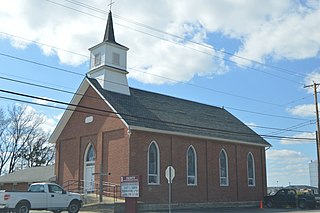
Somersville is an unincorporated community in York Township, Union County, Ohio, United States. It is located at the intersection of Ohio State Routes 31 and 47.
Pharisburg is an unincorporated community in Leesburg Township, Union County, Ohio, United States. It is located at the intersection of Ohio State Routes 4 and 347, about two miles west of Magnetic Springs.
Pottersburg is an unincorporated community in Allen Township, Union County, Ohio, United States. It is located along U.S. Route 33 between Marysville and Bellefountaine, about four miles west of Marysville.

New Dover is an unincorporated community in Dover Township, Union County, Ohio, United States. It is located along U.S. Route 36, about three miles east of Marysville.
Watkins is an unincorporated community in Mill Creek Township, Union County, Ohio, United States. It is located along Watkins Road, between U.S. Route 33 and U.S. Route 42, about five miles east of Marysville.

Maine Prairie is an unincorporated community located in Solano County, California east of Elmira, California on the Maine Prairie Slough at latitude 38.308 and longitude -121.759. The elevation is 7 feet (2.1 m). Maine Prairie appears on the Dozier U.S. Geological Survey Map.

Allentown is an unincorporated community in Tazewell County, Illinois, United States. Allentown is in the Tremont Township, though it is closer to Mackinaw than to Tremont. Allentown is 2.5 miles (4.0 km) northwest of Mackinaw and 6 miles (9.7 km) northeast of Tremont.

The Cleveland and Mahoning Valley Railroad (C&MV) was a shortline railroad operating in the state of Ohio in the United States. Originally known as the Cleveland and Mahoning Railroad (C&M), it was chartered in 1848. Construction of the line began in 1853 and was completed in 1857. After an 1872 merger with two small railroads, the corporate name was changed to "Cleveland and Mahoning Valley Railroad". The railroad leased itself to the Atlantic and Great Western Railway in 1863. The C&MV suffered financial instability, and in 1880 its stock was sold to a company based in London in the United Kingdom. A series of leases and ownership changes left the C&MV in the hands of the Erie Railroad in 1896. The CM&V's corporate identity ended in 1942 after the Erie Railroad completed purchasing the railroad's outstanding stock from the British investors.
Otter is an unincorporated community in Paris Township, Union County, Ohio, United States. It is located at 40°16′33″N83°25′09″W, just northwest of Marysville, on the banks of Otter Run, at the intersection of Dog Leg Road and Westlake-Lee Road.

Willow is an unincorporated community in Wayne County in the U.S. state of Michigan. The community is located within Huron Charter Township. As an unincorporated community, Willow has no legally defined boundaries or population statistics of its own.


