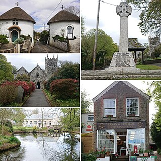
Veryan is a coastal civil parish and village on the Roseland Peninsula in Cornwall, England, United Kingdom. The village has been described as one of Cornwall's loveliest inland villages and as ′a mild tropic garden′ by John Betjeman. It is probably best known for the round-houses, built by the vicar Jeremiah Trist in the early 19th century.
Old Kea is a hamlet in Cornwall, England, United Kingdom. It is situated on the west bank of the Truro River approximately two miles (3 km) south of Truro.

Davidstow is a civil parish and village in north Cornwall, England, United Kingdom. The village is north of Bodmin Moor straddling the A395 road about 3 miles (5 km) north of Camelford. The hamlets of Hallworthy, Hendraburnick, Tremail and Trewassa are in the parish. It was formerly known as Dewstow(e).

Ludgvan is a civil parish and village in Cornwall, England, UK, 2+1⁄2 miles (4 km) northeast of Penzance. Ludgvan village is split between Churchtown, on the hill, and Lower Quarter to the east, adjoining Crowlas. For the purposes of local government, Ludgvan elects a parish council every four years; the town elects a member to Cornwall Council under the Ludgvan division.

Marhamchurch is a civil parish and village in north Cornwall, England, United Kingdom.

Pelynt is a civil parish and village in Cornwall, England, United Kingdom. It is 20 miles (32 km) west of Plymouth and four miles (6.5 km) west-northwest of Looe. Pelynt had a population of around 1,124 at the 2001 census which increased to 1,296 at the 2011 census. In addition, an electoral ward with the same name exists but extends towards Widegates avoiding Looe at all times. The population in 2011 for this ward was 4,453.

Portloe is a small village in Cornwall, England, on the Roseland Peninsula, in the civil parish of Veryan. Portloe harbours two full-time working fishing vessels, the Jasmine and Katy Lil, which fish for crab and lobster in Veryan and Gerrans Bay, and a fleet of smaller leisure boats in summer. Visitors are attracted to Portloe by its fishing, scenery, and walks.

St Goran is a coastal civil parish in Cornwall, England, UK, six miles (10 km) south-southwest of St Austell. The largest settlement in the parish is the coastal village of Gorran Haven, a mile to the east with a further cluster of homes at Trevarrick. The population at the 2011 census was 1,411.
Feock is a coastal civil parish and village in Cornwall, England, United Kingdom. It is about 5 miles (8.0 km) south of Truro at the head of Carrick Roads on the River Fal. To the south, the parish is bordered by Restronguet Creek and to the east by Carrick Roads and the River Fal. To the north, it is bordered by Kea parish and to the west by Perranarworthal parish.

Cubert is a village in Cornwall, England, United Kingdom. It is three miles (5 km) south-southwest of Newquay and is in the civil parish of Cubert.

Gerrans is a coastal civil parish and village on the Roseland Peninsula in Cornwall, England, United Kingdom. The village adjoins Portscatho on the east side of the peninsula. The village is situated approximately seven miles (11 km) south-southeast of Truro.

Ruan Lanihorne is a civil parish and village in south Cornwall, England, United Kingdom. The village is situated approximately four miles (6.5 km) east-southeast of Truro between the River Fal and its tributary the Ruan River.

St Clement is a civil parish and village in Cornwall, England, United Kingdom. It is situated southeast of Truro in the valley of the Tresillian River. Other notable villages within the parish are the much larger Tresillian 1.4 miles (2.3 km) to the north east of St Clement village itself and another village at Malpas to the south of the parish. The urban part of the parish of St Clement was incorporated into Truro in 1895. The remainder of the parish had a population of 1,064 at the 2011 census.

St Just in Roseland is a village and civil parish in Cornwall, England, United Kingdom. The village is 6 miles (10 km) south of Truro and 2 miles (3 km) north of St Mawes, a small village within the parish of St Just in Roseland. The 2011 Census recorded the parish population as 1,158.

St Juliot is a civil parish in north-east Cornwall, England, United Kingdom. The parish is entirely rural and the settlements within it are the hamlets of Beeny and Tresparrett. - plus a part of the adjacent village of Marshgate. The parish population at the 2011 census was 328.

Cardinham is a civil parish and a village in mid Cornwall, England. The village is approximately three-and-a-half miles (6 km) east-northeast of Bodmin. The hamlets of Fletchersbridge, Millpool, Milltown, Mount, Old Cardinham Castle and Welltown are in the parish.

St Breward is a civil parish and village in Cornwall, England, United Kingdom. It is on the western side of Bodmin Moor, about 6 miles (10 km) north of Bodmin. At the 2011 census the parish population including Cooksland and Fentonadle was 919.

St Gennys is a coastal civil parish and small settlement in north Cornwall, England, United Kingdom.

Lansallos is a village in the civil parish of Polperro in south Cornwall, England, United Kingdom. It is situated between Polruan and Polperro about 5 miles (8 km) east of Fowey in Liskeard Registration District.

St Anthony in Roseland is a village and a former parish in Cornwall, England, in the United Kingdom. It is a small settlement on the Roseland Peninsula.

