Related Research Articles

Falmouth is a town, civil parish and port on the River Fal on the south coast of Cornwall, England, United Kingdom. It has a total resident population of 21,797.
Geraint, known in Latin as Gerontius, was a King of Dumnonia who ruled in the early 8th century. During his reign, it is believed that Dumnonia came repeatedly into conflict with the neighbouring Anglo-Saxon Kingdom of Wessex. Geraint was the last recorded king of a unified Dumnonia, and was called King of the Welsh by the Anglo-Saxon Chronicle. Subsequent kings of Dumnonia reigned over an area that was eventually reduced to the limits of present-day Cornwall.

In the Matter of Britain, Igraine is the mother of King Arthur. Igraine is also known in Latin as Igerna, in Welsh as Eigr, in French as Ygraine, in Le Morte d'Arthur as Ygrayne—often modernised as Igraine or Igreine—and in Parzival as Arnive. She becomes the wife of Uther Pendragon, after the death of her first husband, Gorlois.

Dumnonia is the Latinised name for a Brythonic kingdom that existed in Sub-Roman Britain between the late 4th and late 8th centuries CE in the more westerly parts of present-day South West England. It was centred in the area of modern Devon, but also included modern Cornwall and part of Somerset, with its eastern boundary changing over time as the gradual westward expansion of the neighbouring Anglo-Saxon kingdom of Wessex encroached on its territory. The spelling Damnonia is sometimes encountered, but that spelling is also used for the land of the Damnonii, later part of the Kingdom of Strathclyde, in present-day southern Scotland. The form Domnonia also occurs and shares a linguistic relationship with the Breton region of Domnonée.

In Arthurian legend, Gorlois of Tintagel, Duke of Cornwall, is the first husband of Igraine, whose second husband is Uther Pendragon. Gorlois's name first appears in Geoffrey of Monmouth's Historia Regum Britanniae. A vassal of Ambrosius Aurelianus, his arrival at the Battle of Kaerconan ensures the defeat of Hengist. In Wace's Roman de Brut, when Hengist's son Octa and his cousin Ossa rebel, Gorlois helps Uther defeat them at York.

St Just, known as St Just in Penwith, is a town and civil parish in the Penwith district of Cornwall, England, United Kingdom. It lies along the B3306 road which connects St Ives to the A30 road. The parish encompasses the town of St Just and the nearby settlements of Trewellard, Pendeen and Kelynack: it is bounded by the parishes of Morvah to the north-east, Sancreed and Madron to the east, St Buryan and Sennen to the south and by the sea in the west. The parish consists of 7,622 acres (3,085 ha) of land, 12 acres (4.9 ha) of water and 117 acres (47.3 ha) of foreshore. The town of St Just is the most westerly town in mainland Britain and is situated approximately 8 miles (13 km) west of Penzance along the A3071. St Just parish, which includes Pendeen and the surrounding area, has a population of 4,637. An electoral ward of the same name also exists: the population of this ward at the same census was 4,812.

Henry Jenner was a British scholar of the Celtic languages, a Cornish cultural activist, and the chief originator of the Cornish language revival.
Robert Morton Nance (1873–1959) was a leading authority on the Cornish language, nautical archaeologist, and joint founder of the Old Cornwall Society.

Coverack is a coastal village and fishing port in Cornwall, England. It lies in the parish of St Keverne, on the east side of the Lizard peninsula about nine miles (14 km) south of Falmouth.

Castle an Dinas is an Iron Age hillfort at the summit of Castle Downs near St Columb Major in Cornwall, UK and is considered one of the most important hillforts in the southwest of Britain. It dates from around the 3rd to 2nd century BCE and consists of three ditch and rampart concentric rings, 850 feet (260 m) above sea level. During the early 1960s it was excavated by a team led by Dr Bernard Wailes of the University of Pennsylvania during two seasons of excavation.

Zone Point is the southernmost extremity of the Roseland peninsula extending into Falmouth Bay near St Mawes in Cornwall, United Kingdom at grid reference SW8430.

The Royal Cornwall Agricultural Show, usually called the Royal Cornwall Show, is an agricultural show organised by the Royal Cornwall Agricultural Association, which takes place at the beginning of June each year, at Wadebridge in north Cornwall, England, United Kingdom. The showground is on the south side of the A39 main road and between the hamlets of St Breock and Whitecross. Members of the Royal family often attend at the Show, including Prince Charles who is a supporter of the farming community. Princess Alexandra attended the 2009 show. The show lasts for three days and attracts approximately 120,000 visitors annually.

Boscawen-Ûn is a Bronze Age stone circle close to St Buryan in Cornwall, UK. It consists of nineteen upright stones in an ellipse with another, leaning, middle stone just south of the centre. There is a west-facing gap in the circle, which may have formed an entrance. The elliptical circle has diameters 24.9 and 21.9 metres. It is located at grid reference SW412274.
This timeline summarizes significant events in the History of Cornwall
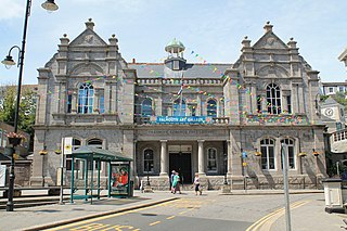
Falmouth Art Gallery is a publicly funded art gallery in Cornwall, with one of the leading art collections in Cornwall and southwest England, which features work by old masters, major Victorian artists, British and French Impressionists, leading surrealists and maritime artists, children's book illustrators, automata, contemporary painters and printmakers. It is located on The Moor, on the upper floor of the Municipal Buildings above the Library in Falmouth, Cornwall.

Lamorran is a village 3+1⁄2 miles (5.6 km) southeast of Truro in Cornwall, England. Lamorran lies within the Cornwall Area of Outstanding Natural Beauty (AONB).

Cornish promontory forts, commonly known in Cornwall as cliff castles, are coastal equivalents of the hill forts and Cornish "rounds" found on Cornish hilltops and slopes. Similar coastal forts are found on the north–west European seaboard, in Normandy, Brittany and around the coastlines of the British Isles, especially in Wales, Scotland and Ireland. Many are known in southwest England, particularly in Cornwall and its neighbouring county, Devon. Two have been identified immediately west of Cornwall, in the Isles of Scilly.
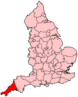
The following outline is provided as an overview of and topical guide to Cornwall: Cornwall – ceremonial county and unitary authority area of England within the United Kingdom. Cornwall is a peninsula bordered to the north and west by the Celtic Sea, to the south by the English Channel, and to the east by the county of Devon, over the River Tamar. Cornwall is also a royal duchy of the United Kingdom. It has an estimated population of half a million and it has its own distinctive history and culture.
Presented below is an alphabetical index of articles related to Cornwall:

Penmere Manor Hotel near Falmouth, Cornwall, is a house of historical significance and is Grade II listed on the English Heritage Register. It was built in about 1825 by a wealthy sea captain and was the home of numerous notable people over the next 150 years. It is now a hotel which provides accommodation and restaurant facilities and has a leisure club.
References
- ↑ Ordnance Survey One-inch Map of Great Britain; Truro and Falmouth, sheet 190. 1961
- ↑ Jenner, Henry (1922). "The Royal House of Damnonia". Annual Report of the Royal Cornwall Polytechnic Society. New Series. Plymouth and Falmouth. 4: 139.
| Unitary authorities | |
|---|---|
| Major settlements |
|
| Rivers | |
| Topics | |
Coordinates: 50°12′35″N4°57′17″W / 50.2097°N 4.9546°W
| | This Cornwall location article is a stub. You can help Wikipedia by expanding it. |