
Lakeview is a town in Lake County, Oregon, United States. The population was 2,418 at the 2020 census. It is the county seat of Lake County. The city bills itself as the "Tallest Town in Oregon" because of its elevation, 4,757 feet (1,450 m) above sea level. Lakeview is situated in the Goose Lake Valley at the foot of the Warner Mountains and at the edge of Oregon's high desert country. Its economy is based on agriculture, lumber production, and government activities. In addition, tourism is an increasingly important part of the city's economy. Oregon's Outback Scenic Byway passes through Lakeview.
The Fremont-Winema National Forest of south central Oregon is a mountainous region with a rich geological, ecological, archaeological, and historical history. Founded in 1908, the Fremont National Forest was originally protected as the Goose Lake Forest Reserve in 1906. The name was soon changed to Fremont National Forest, named after John C. Frémont, who explored the area for the United States Army Corps of Engineers in 1843. It absorbed part of Paulina National Forest on July 19, 1915. In 2002, it was administratively combined with the Winema National Forest as the Fremont–Winema National Forests.
The Fremont–Winema National Forest is a United States National Forest formed from the 2002 merger of the Fremont and Winema National Forests. They cover territory in southern Oregon from the crest of the Cascade Range on the west past the city of Lakeview to the east. The northern end of the forests is bounded by U.S. Route 97 on the west and Oregon Route 31 on the east. To the south, the state border with California forms the boundary of the forests. Klamath Falls is the only city of significant size in the vicinity. The forests are managed by the United States Forest Service, and the national forest headquarters are located in Lakeview.

The Deschutes National Forest is a United States national forest (NF) located in Central Oregon, in parts of Deschutes, Klamath, Lake, and Jefferson counties. It was established in 1908, with border changes following in 1911 and 1915. The forest now encompasses almost 1.6 million acres (6,500 km2) along the east side of the Cascade Range. The forest is bordered to the south by the Fremont–Winema NF, to the southwest by the Umpqua NF, and to the west by the Willamette NF.

The Sky Lakes Wilderness is a wilderness area located in the Rogue River–Siskiyou and Fremont–Winema national forests in the southern Cascade Range of Oregon in the United States. It comprises 116,300 acres (47,100 ha), of which 75,695 acres (30,633 ha) are in the Rogue River–Siskiyou National Forest and 40,605 acres (16,432 ha) are in the Fremont–Winema National Forest. It was established in 1984 under the Wilderness Act of 1964.

Yamsay Mountain is a large shield volcano in the Cascade Range of south-central Oregon, located about 35 miles (56 km) east of Crater Lake on the border between Klamath County and Lake County. It is part of the Cascade Volcanic Arc but is located in a mountain range 30 to 50 miles behind the main Cascade volcanic front. The best known members of this enigmatic arc are the massive shields of Newberry Volcano, about 55 miles (89 km) farther north in Oregon, and Medicine Lake Volcano, about 80 miles (130 km) south in Northern California. Yamsay is the highest volcano in the eastern arc, almost 300 feet (90 m) higher than Newberry and Medicine Lake.

The pearl crescent is a butterfly of North America. It is found in all parts of the United States except the west coast, and throughout Mexico and parts of southern Canada, in particular Ontario. Its habitat is open areas such as pastures, road edges, vacant lots, fields, open pine woods. Its pattern is quite variable. Males usually have black antenna knobs. Its upperside is orange with black borders; postmedian and submarginal areas are crossed by fine black marks. The underside of the hindwing has a dark marginal patch containing a light-colored crescent.

Chandler State Wayside is a state park in south-central Oregon in the United States. It is named in honor of Solomon and Hattie Chandler, who donated the land for the park. The park covers 85 acres (34 ha) of pine forest along a creek. The park provides restrooms and other basic facilities to accommodate the traveling public. Chandler State Wayside is administered by the Oregon Parks and Recreation Department.

Gearhart Mountain Wilderness is a wilderness area located within the Fremont–Winema National Forest in Lake County and Klamath County in south-central Oregon. This area was established in 1943 as a Wild Area and designated as wilderness with the Wilderness Act of 1964. In 1984, an additional 4,144 acres (1,677 ha) were added for a total of 22,823 acres (9,236 ha). The wilderness is entirely within the Bly Ranger District.

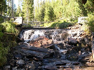
The Wood River is a short river in the southern region of the U.S. state of Oregon, and part of the Klamath Basin drainage. It flows 18 miles (29 km) through the Fremont-Winema National Forests, Bureau of Land Management land, and private property in southern Oregon. Its watershed consists of 220 square miles (570 km2) of conifer forest, rural pasture land, and marsh. The river provides habitat for many species of wildlife including an adfluvial (migratory) and resident populations of native Great Basin redband trout.

The Eastern Cascades Slopes and Foothills ecoregion is a Level III ecoregion designated by the United States Environmental Protection Agency (EPA) in the U.S. states of Oregon, Washington, and California. In the rain shadow of the Cascade Range, the eastern side of the mountains experiences greater temperature extremes and receives less precipitation than the west side. Open forests of ponderosa pine and some lodgepole pine distinguish this region from the Cascades ecoregion, where hemlock and fir forests are more common, and from the lower, drier ecoregions to the east, where shrubs and grasslands are predominant. The vegetation is adapted to the prevailing dry, continental climate and frequent wildfire. Volcanic cones and buttes are common in much of the region.

The Goose Lake Valley is located in south-central Oregon and northeastern California in the United States. It is a high valley at the northwestern corner of North America's Great Basin. Much of the valley floor is covered by Goose Lake, a large endorheic lake that straddles the Oregon–California border. Native Americans inhabited the Goose Lake Valley for thousands of years before explorers arrived in the 19th century. The pioneer wagon route known as the Applegate Trail crossed the Goose Lake Valley on its way to southern Oregon. At the south end of Goose Lake, the Lassen Cutoff separated from the Applegate Trail and headed south toward the Sacramento Valley. Today, Lakeview, Oregon, is the largest settlement in the valley. Livestock ranching and lumber mills are the valley's main commercial activity. The Goose Lake Valley offers a number of recreational opportunities including hang-gliding, hunting, fishing, and birdwatching.

Phyciodes pallida, the pale crescent or pallid crescentspot, is a species of butterfly in the family Nymphalidae. It is found in western North America.

Phyciodes mylitta, the Mylitta crescent or Mylitta crescentspot, is a butterfly of the family Nymphalidae. It is found in western North America.

Perideridia erythrorhiza is a rare species of flowering plant in the family Apiaceae known by the common names western yampah and redroot yampah. It is endemic to Oregon in the United States, where there are about 20 occurrences. The populations occur in three regions in southwestern Oregon, which are separated by more than 50 miles (80 km). The three separate groups are in the Klamath Mountains and on either side of the Cascade Range.
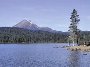
Lake of the Woods is a natural lake near the crest of the Cascade Range in the Fremont–Winema National Forest in southern Oregon in the United States. The lake covers 1,146 acres (4.64 km2). It was named by Oliver C. Applegate in 1870. Today, the Oregon Department of Fish and Wildlife manages the lake's fishery. The small unincorporated community of Lake of the Woods is located on the east shore of the lake. Lake of the Woods is one of southern Oregon's most popular outdoor recreation sites.

Hager Mountain is a volcanic peak in Oregon in the northwest corner of the Basin and Range Province in the United States. The mountain is located south of the small unincorporated community of Silver Lake in south-central Oregon, and it is in the Fremont–Winema National Forest. On the summit, there is a fire lookout operated during the summer and fall by the United States Forest Service. There are several hiking trails that lead to the lookout station.

The Barry Point Fire was a wildfire that burned over 92,977 acres (376.26 km2) of Oregon and California forest land during the summer of 2012. The fire began on 5 August 2012, the result of a lightning strike. The fire consumed public forest and rangeland as well as private forest and grazing land located in Lake County, Oregon and Modoc County, California. The public lands affected by the fire are administered by the United States Forest Service and the Oregon Department of Forestry. The largest part of the private land was owned by the Collins Timber Company. At the peak of the firefighting effort, there were 1,423 personnel working on the fire. It took 22 days to fully contain the fire and then an additional three weeks to mop it up.

Crane Mountain is in the Warner Mountain range and is the tallest peak in Lake County, Oregon, U.S. It is located southeast of Lakeview in south-central Oregon, near the northwest corner of the Basin and Range Province of the western United States. The mountain is in the Fremont section of the Fremont–Winema National Forest. There was a United States Forest Service fire lookout located near the summit which was removed in 1972. The Crane Mountain National Recreation Trail runs north and south along the crest of the mountain.
