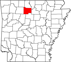
Pindall, Arkansas | |
---|---|
Coordinates: 36°03′49″N92°51′44″W / 36.06361°N 92.86222°W | |
Country | United States |
State | Arkansas |
County | Searcy |
Area | |
• Total | 2.87 sq mi (7.44 km2) |
• Land | 2.87 sq mi (7.44 km2) |
• Water | 0.00 sq mi (0.00 km2) |
Elevation | 1,194 ft (364 m) |
Population (2020) | |
• Total | 95 |
• Density | 33.09/sq mi (12.78/km2) |
Time zone | UTC-6 (Central (CST)) |
• Summer (DST) | UTC-5 (CDT) |
ZIP code | 72669 |
Area code | 870 |
FIPS code | 05-55280 |
GNIS feature ID | 2407113 [2] |
Pindall is a town in Searcy County, Arkansas, United States. The population was 112 at the 2010 census. The town is said to be named for Governor Xenophon Overton Pindall.[ citation needed ]
According to the United States Census Bureau, the town has a total area of 2.9 square miles (7.5 km2), all land.
Pindall is in the Ozark Mountain School District, [3] with a K-12 campus in nearby St. Joe. [4]
Census | Pop. | Note | %± |
---|---|---|---|
1990 | 135 | — | |
2000 | 95 | −29.6% | |
2010 | 112 | 17.9% | |
2020 | 95 | −15.2% | |
U.S. Decennial Census [5] |
At the 2000 census there were 95 people, 36 households, and 30 families in the town. The population density was 33.1 inhabitants per square mile (12.8/km2). There were 54 housing units at an average density of 18.8 per square mile (7.3/km2). The racial makeup of the town was 97.89% White and 2.11% Native American. [6] Of the 36 households 41.7% had children under the age of 18 living with them, 69.4% were married couples living together, 8.3% had a female householder with no husband present, and 13.9% were non-families. 13.9% of households were one person and 8.3% were one person aged 65 or older. The average household size was 2.64 and the average family size was 2.87.
The age distribution was 25.3% under the age of 18, 5.3% from 18 to 24, 32.6% from 25 to 44, 20.0% from 45 to 64, and 16.8% 65 or older. The median age was 38 years. For every 100 females, there were 106.5 males. For every 100 females age 18 and over, there were 102.9 males.
The median household income was $32,500 and the median family income was $32,750. Males had a median income of $28,750 versus $18,750 for females. The per capita income for the town was $12,550. There were 16.0% of families and 21.6% of the population living below the poverty line, including 38.9% of under eighteens and 22.2% of those over 64.
Stone County is located in the Ozark Mountains in the U.S. state of Arkansas. The county is named for rugged, rocky area terrain of the Ozarks. Created as Arkansas's 74th county on April 21, 1873, Stone County has two incorporated cities: Mountain View, the county seat and most populous city, and Fifty-Six. The county is also the site of numerous unincorporated communities and ghost towns.
Searcy County is a county located in the U.S. state of Arkansas. As of the 2020 census, the population was 7,828. The county seat is Marshall. The county was formed December 13, 1838, from a portion of Marion County and named for Richard Searcy, the first clerk and judge in the Arkansas Territory. The city of Searcy, Arkansas, some 70 miles away, shares the name despite having never been part of Searcy County. The county is an alcohol prohibition or dry county.
Boone County is located in the U.S. state of Arkansas, along the Missouri border. As of the 2020 census, the population was 37,373. The county seat is Harrison. It is Arkansas's 62nd county, formed on April 9, 1869.
Ozark is a city in and the county seat of Dale County, Alabama. As of the 2010 census, the population of the city was 14,907.
Big Flat is a town in Baxter and Searcy counties in the U.S. state of Arkansas. The population was 88 at the 2020 census.
Everton is a town in Boone County, Arkansas, United States. The population was 133 at the 2010 census. It is part of the Harrison Micropolitan Statistical Area.
Lead Hill is a town in Boone County, Arkansas, United States. The population was 271 at the 2010 census. It is part of the Harrison Micropolitan Statistical Area.
Western Grove is a town in northeastern Newton County, Arkansas, United States. The population was 384 at the 2010 census. It is part of the Harrison Micropolitan Statistical Area.
Gilbert is a town in Searcy County, Arkansas, United States. The population was 26 at the 2020 census, ranking it as the smallest municipality in the state and one of the smallest in the nation. Over the years, Gilbert has gained a reputation as one of the coldest locations in Arkansas.
Leslie is a city in Searcy County, Arkansas, United States. Located within the Boston Mountains, the most rugged subset of The Ozarks, the city was founded as a railroad and lumber town. Renamed from the original Wiley's Cove in 1887, the city saw prosperity relating to these industries through the 1920s. Today, this history is available to residents and visitors in the form of several properties listed on the National Register of Historic Places throughout the city. The population was 441 at the 2010 census.
Marshall is the largest city in and county seat of Searcy County in Arkansas, United States. It is located in the Ozarks at the foot of the Boston Mountain Range 10.5 mi (16.9 km) south of America's first National River, the Buffalo National River. Marshall serves as a hub for area tourism including camping, floating, hiking, bicycling and Dark Sky viewing.
St. Joe or Saint Joe is a town in Searcy County, Arkansas, United States. The population was 132 at the 2010 census.
Greenland is a city in Washington County, Arkansas, United States. The population is 1,213 as of the 2020 census. The community is located in the Boston Mountains, within the Ozark Mountains.
Judsonia is a city in White County, Arkansas, United States. Stan Robinson is the current mayor, first elected in 2018. The population was 1,854 at the 2020 census. The city is located immediately northeast of neighboring Searcy, and north of the Little Red River before it turns southeast toward the White River.
Purdy is a city in Purdy Township, Barry County, Missouri, United States, on the foothills of the Ozarks, eight miles south of Monett and twelve miles north of Cassville along Highway 37. The population was 1,098 at the 2010 census.
Warsaw is a city located in Benton County, Missouri, United States. The population was 2,209 at the 2020 census. Warsaw is the county seat of Benton County.
Ozark is a city in and the county seat of Christian County, Missouri. Its population was 21,284 as of the 2020 census. Ozark is also the third largest city in the Springfield, Missouri Metropolitan Area, and is centered along a business loop of U.S. Route 65, where it intersects with Missouri Route 14.
Mountain View is a city in northeastern Howell County, Missouri, United States. The population was 2,533 at the 2020 census.
Ironton is a city in Iron County, Missouri, United States. The population was 1,475 at the 2020 census. It is the county seat of Iron County, and is located 12 miles south of Belgrade.
Birch Tree is a city in southwest Shannon County, Missouri, United States. The population was 541 at the 2020 census.