Pinukpuk, Kalinga

Last updated
Pinukpuk
Municipality of Pinukpuk
Ph locator kalinga pinukpuk.png
Map of Kalinga with Pinukpuk highlighted
Pinukpuk, Kalinga
Philippines location map (square).svg
Red pog.svg
Pinukpuk
Location within the Philippines
Coordinates: 17°36′N121°22′E / 17.6°N 121.37°E / 17.6; 121.37 Coordinates: 17°36′N121°22′E / 17.6°N 121.37°E / 17.6; 121.37
Country Flag of the Philippines.svg  Philippines
Region Cordillera Administrative Region (CAR)
Province Kalinga
District Lone District
Barangays 23 (see Barangays)
Government
[1]
  Type Sangguniang Bayan
   Mayor Irving B. Dasayon
   Vice Mayor Jimmy B. Dasayon
  CongressmanAllen Jesse C. Mangaoang
  Electorate20,200 voters (2019)
Area
[2]
  Total743.56 km2 (287.09 sq mi)
Elevation
130.6 m (428.5 ft)
Population
 (2015 census) [3]
  Total32,026
  Density43/km2 (110/sq mi)
  Households
6,258
Economy
   Income class 1st municipal income class
   Poverty incidence 30.36% (2015) [4]
  Revenue (₱)156,049,808.35 (2016)
Time zone UTC+8 (PST)
ZIP code
3806
PSGC
IDD : area code +63(0)74
Climate type tropical rainforest climate
Native languagesKalinga language
Ilocano
Tagalog
Website www.pinukpuk.gov.ph

Pinukpuk, officially the Municipality of Pinukpuk is a 1st class municipality in the province of Kalinga, Philippines. According to the 2015 census, it has a population of 32,026 people. [3]

Contents

It is in the northern part of Kalinga province, which is a gateway to Tuao, Cagayan, and Conner, Apayao.

Barangays

Pinukpuk is politically subdivided into 23 barangays. [2]

Climate

Climate data for Pinukpuk, Kalinga
MonthJanFebMarAprMayJunJulAugSepOctNovDecYear
Average high °C (°F)26
(79)
27
(81)
29
(84)
32
(90)
32
(90)
31
(88)
31
(88)
30
(86)
30
(86)
29
(84)
27
(81)
26
(79)
29
(85)
Average low °C (°F)20
(68)
21
(70)
22
(72)
23
(73)
24
(75)
25
(77)
24
(75)
25
(77)
24
(75)
23
(73)
23
(73)
21
(70)
23
(73)
Average precipitation mm (inches)109
(4.3)
78
(3.1)
64
(2.5)
54
(2.1)
181
(7.1)
196
(7.7)
204
(8.0)
211
(8.3)
174
(6.9)
198
(7.8)
185
(7.3)
231
(9.1)
1,885
(74.2)
Average rainy days17.213.713.213.021.723.425.225.221.917.718.620.8231.6
Source: Meteoblue [5]

Demographics

Population census of Pinukpuk
YearPop.±% p.a.
1918 5,397    
1939 4,353−1.02%
1948 4,612+0.64%
1960 7,030+3.57%
1970 10,470+4.06%
1975 11,557+2.00%
1980 17,362+8.48%
1990 20,102+1.48%
1995 23,057+2.60%
2000 26,130+2.72%
2007 27,783+0.85%
2010 29,596+2.33%
2015 32,026+1.51%
Source: Philippine Statistics Authority [3] [6] [7] [8]


In the 2015 census, the population of Pinukpuk was 32,026 people, [3] with a density of 43 inhabitants per square kilometre or 110 inhabitants per square mile.

Related Research Articles

Kalinga (province) Province of the Philippines

Kalinga is a landlocked province in the Philippines situated within the Cordillera Administrative Region in Luzon. Its capital is Tabuk and borders Mountain Province to the south, Abra to the west, Isabela to the east, Cagayan to the northeast, and Apayao to the north. Kalinga and Apayao are the result of the 1995 partitioning of the former province of Kalinga-Apayao which was seen to better service the respective needs of the various indigenous peoples in the area.

Aguinaldo, Ifugao Municipality in Cordillera Administrative Region, Philippines

Aguinaldo, officially the Municipality of Aguinaldo, is a 2nd class municipality in the province of Ifugao, Philippines. According to the 2015 census, it has a population of 19,408 people.

Bucloc Municipality in Cordillera Administrative Region, Philippines

Bucloc, officially the Municipality of Bucloc, is a 6th class municipality in the province of Abra, Philippines. According to the 2015 census, it has a population of 2,501 people.

Daguioman Municipality in Cordillera Administrative Region, Philippines

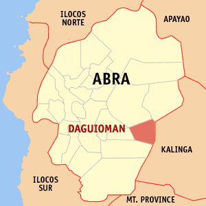
Daguioman, officially the Municipality of Daguioman, is a 5th class municipality in the province of Abra, Philippines. According to the 2015 census, it had a population of 2,088 people.

Boliney Municipality in Cordillera Administrative Region, Philippines

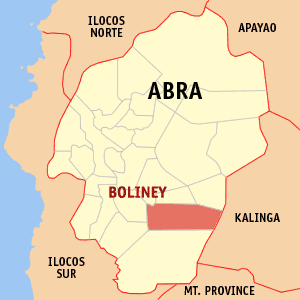
Boliney, officially the Municipality of Boliney, is a 5th class municipality in the province of Abra, Philippines. According to the 2015 census, it has a population of 3,573 people.

Pilar, Abra Municipality in Cordillera Administrative Region, Philippines

Pilar, officially the Municipality of Pilar, is a municipality in the province of Abra in the Cordillera Administrative Region (CAR) of the Philippines. The population was 10,223 at the 2015 census.

Tubo, Abra Municipality in Cordillera Administrative Region, Philippines

Tubo, officially the Municipality of Tubo,, is a 4th class municipality in the province of Abra, Philippines. According to the 2015 census, it has a population of 5,699 people.

Kabugao Municipality in Cordillera Administrative Region, Philippines

Kabugao, officially the Municipality of Kabugao,, is a 1st class municipality and capital of the province of Apayao, Philippines. According to the 2015 census, it has a population of 15,537 people.

Balbalan, Kalinga Municipality in Cordillera Administrative Region, Philippines

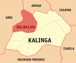
Balbalan, officially the Municipality of Balbalan is a 3rd class municipality in the province of Kalinga, Philippines. According to the 2015 census, it has a population of 12,195 people.

Lubuagan Municipality in Cordillera Administrative Region, Philippines

Lubuagan, officially the Municipality of Lubuagan is a 4th class municipality in the province of Kalinga, Philippines. According to the 2015 census, it has a population of 8,733 people.

Pasil, Kalinga Municipality in Cordillera Administrative Region, Philippines

Pasil, officially the Municipality of Pasil is a 5th class municipality in the province of Kalinga, Philippines. According to the 2015 census, it has a population of 9,644 people.

Rizal, Kalinga Municipality in Cordillera Administrative Region, Philippines

Rizal, officially the Municipality of Rizal is a 4th class municipality in the province of Kalinga, Philippines. According to the 2015 census, it has a population of 17,038 people.

Tabuk, Kalinga Component city in Cordillera Administrative Region, Philippines

Tabuk,, officially the City of Tabuk, or simply referred to as Tabuk City, is a 5th class city and capital of the province of Kalinga, Philippines. According to the 2015 census, it has a population of 110,642 people.

Tanudan, Kalinga Municipality in Cordillera Administrative Region, Philippines

Tanudan, officially the Municipality of Tanudan is a 4th class municipality in the province of Kalinga, Philippines. According to the 2015 census, it has a population of 9,534 people.

Tinglayan, Kalinga Municipality in Cordillera Administrative Region, Philippines

Tinglayan, officially the Municipality of Tinglayan is a 4th class municipality in the province of Kalinga, Philippines. According to the 2015 census, it has a population of 12,868 people.

Alfonso Lista, Ifugao Municipality in Cordillera Administrative Region, Philippines

Alfonso Lista, formerly known as Potia, officially the Municipality of Alfonso Lista is a 3rd class municipality in the province of Ifugao, Philippines. According to the 2015 census, it has a population of 32,119 people.

Hingyon, Ifugao Municipality in Cordillera Administrative Region, Philippines

Hingyon, officially the Municipality of Hingyon is a 5th class municipality in the province of Ifugao, Philippines. According to the 2015 census, it has a population of 9,227 people.

Hungduan, Ifugao Municipality in Cordillera Administrative Region, Philippines

Hungduan, officially the Municipality of Hungduan is a 4th class municipality in the province of Ifugao, Philippines. According to the 2015 census, it has a population of 9,400 people.

Lagawe, Ifugao Municipality in Cordillera Administrative Region, Philippines

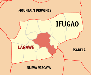
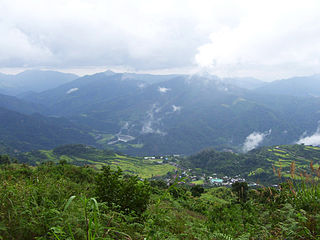
Lagawe, officially the Municipality of Lagawe is a 4th class municipality and capital of the province of Ifugao, Philippines. According to the 2015 census, it has a population of 19,333 people.

Tinoc, Ifugao Municipality in Cordillera Administrative Region, Philippines

Tinoc, officially the Municipality of Tinoc is a 4th class municipality in the province of Ifugao, Philippines. According to the 2015 census, it has a population of 16,559 people.

References

  1. "Municipality". Quezon City, Philippines: Department of the Interior and Local Government. Retrieved 31 May 2013.
  2. 1 2 "Province: Kalinga". PSGC Interactive. Quezon City, Philippines: Philippine Statistics Authority . Retrieved 12 November 2016.
  3. 1 2 3 4 Census of Population (2015). "Cordillera Administrative Region (CAR)". Total Population by Province, City, Municipality and Barangay. PSA . Retrieved 20 June 2016.
  4. "PSA releases the 2015 Municipal and City Level Poverty Estimates". Quezon City, Philippines. Retrieved 12 October 2019.
  5. "Pinukpuk: Average Temperatures and Rainfall". Meteoblue. Retrieved 8 March 2020.
  6. Census of Population and Housing (2010). "Cordillera Administrative Region (CAR)". Total Population by Province, City, Municipality and Barangay. NSO . Retrieved 29 June 2016.
  7. Censuses of Population (1903–2007). "Cordillera Administrative Region (CAR)". Table 1. Population Enumerated in Various Censuses by Province/Highly Urbanized City: 1903 to 2007. NSO.
  8. "Province of Kalinga". Municipality Population Data. Local Water Utilities Administration Research Division. Retrieved 17 December 2016.