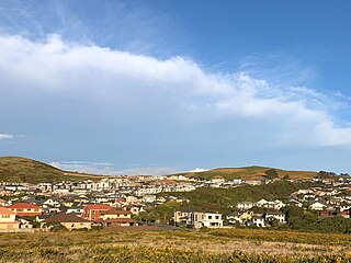
Berhampore is a suburb of Wellington, New Zealand. It lies towards the south of the city, four kilometres from the city centre, and two kilometres from the coast of Cook Strait. It is surrounded by the suburbs of Vogeltown, Newtown, Melrose, Island Bay, Kingston, and Mornington. The suburb was named after Berhampore in Bengal, one of the battlefields at the start of the Battle of Plassey of 1757. Also surrounding Berhampore is the Berhampore Golf Course as well as a very extensive green belt with many walkways and tracks connecting outlying areas. The suburb also boasts some of Wellington's best all weather sports fields, on Adelaide Road and the national hockey stadium. Alongside the golf course there is a skateboard/bmx park, right by a kids mountain bike track. Berhampore School opened in 1915.

Kelburn is a central suburb of Wellington, the capital city of New Zealand, situated within 1 kilometre (0.62 mi) of the central business district.

Thorndon is a historic inner suburb of Wellington, the capital city of New Zealand. Because the suburb is relatively level compared to the hilly terrain elsewhere in Wellington it contained Wellington's elite residential area until its best was destroyed in the 1960s by a new motorway and the erection of tall office buildings on the sites of its Molesworth Street retail and service businesses.

Mornington is a suburb of Wellington, New Zealand, on the southern hills behind Brooklyn. It is named after the Duke of Wellington's father, the Earl of Mornington. The original Mornington is in County Meath, and was the Irish seat of the Duke's father. It was named in 1878 from the time when J.F.E. Wright (1827-1891) subdivided his land in the south-west of the city in partnership with Jacob Joseph, and created the suburbs of Mornington and Vogeltown.

Te Horo and Te Horo Beach are two localities on the Kāpiti Coast of New Zealand's North Island. Te Horo Beach is the larger of the two settlements and, as its name implies, is located on the Tasman Sea coast. Te Horo is located to the east, a short distance inland. They are situated between Peka Peka and Waikanae to the south and Ōtaki to the north. "Te Horo" in the Māori language means "the landslide".

Northland is a suburb in west-central Wellington, New Zealand. Not far from Victoria University it also includes low-priced accommodation popular with young students. It borders the suburbs of Highbury, Kelburn, Thorndon, Wilton, Wadestown and Karori. Northland is populated by a mix of university students, young professionals and families. Part of the area was known as Creswick until the late 19th century when new roads and building sites were developed by the landowner, C J Pharazyn, who marketed the whole area as Northland. At that time it was described in The Evening Post as "Wellington's best suburb".

Wilton is a small suburb in Wellington. It is best known for Otari-Wilton's Bush, a large reserve that is situated in the suburb. Otari-Wilton's bush is the only public botanic garden in New Zealand dedicated solely to native plants. It features 14 km of walking tracks and a 'canopy walkway'. The canopy walkway is a raised walkway that provides a unique chance to view life in, and from, the top level of trees such as mature tawa, rewarewa and hinau.

Sawyers Bay is a suburb of the New Zealand city of Dunedin. It is located 1.5 kilometres (0.93 mi) to the southwest of Port Chalmers in a wide valley on the shore of Mussel Bay, 13 kilometres (8.1 mi) to the northeast of Dunedin city centre.

Boulcott is a central suburb of Lower Hutt, in the Wellington Region of New Zealand. The suburb lies about a kilometre north-east of the Lower Hutt CBD.
Glendale is a suburb of Wainuiomata, part of Lower Hutt city situated in the lower North Island of New Zealand.

The suburb of Newtown lies in the southern part of Wellington in New Zealand. It lies east of Vogeltown, between Mount Cook and Berhampore. The main thoroughfares of Newtown are Riddiford St, leading from Mount Cook to Berhampore and Melrose, and Constable St, leading from Newtown to Kilbirnie.

Wellington Central is an inner-city suburb of Wellington, and the financial heart of both the city and the Wellington Region. It comprises the northern part of the central business district, with the majority of Wellington's high-rise buildings.

Crofton Downs is an inner suburb of Wellington, the capital city of New Zealand. It is situated between Ngaio to the northeast, Wilton to the south-west, and Wadestown to the south. Its border runs on the Korimako Stream that flows south into the Kaiwharawhara Stream and then flows down the Ngaio Gorge into Wellington Harbour.

Grenada North is a small suburb in northern Wellington, New Zealand. It is 5 km south of Porirua's city centre, and 13 km north of Wellington's city centre. Its western boundary is formed by State Highway 1 and Takapu Road. The suburb itself was named after Grenada in the Caribbean, and most streets are named after Caribbean islands.

Strathmore Park is a suburb of Wellington City, New Zealand. It is located at the southern end of the Miramar Peninsula to the south of the suburb of Miramar, and due east of the airport. A hill suburb, it overlooks Lyall Bay, Evans Bay and several bays along the Seatoun coast close to the mouth of Wellington Harbour, which lies to the east.

Karaka Bays is a suburb of Wellington, New Zealand. It lies on the northeast coast of the Miramar Peninsula, 6 km east-south-east of the city centre, and has an expansive view of Wellington Harbour. It takes its name from a New Zealand native tree, the karaka or New Zealand laurel.

Woodridge is one of the northern suburbs of Wellington, New Zealand, north of Newlands and Paparangi.

Broadmeadows is a minor western suburb of Wellington, New Zealand. It is located to the north of Khandallah and south of Johnsonville. It is located 7 kilometres (4.3 mi) from the Wellington central business district. Despite its name suggesting that the area was once flat open fields, the suburb was created on steeply sloping hills and features the highest streets within Wellington City with a number of houses located more than 300m above sea level. Broadmeadows has a population of 1,635.

Southgate is a suburb of Wellington, New Zealand, in the Paekawakawa/Southern Ward. The main road is Buckley Road, which runs south from the point at which Mount Albert Road changes name to Houghton Bay Road.
Northcote is a suburb on the northern side of Christchurch, New Zealand.


