
The Andes, Andes Mountains or Andean Mountain Range are the longest continental mountain range in the world, forming a continuous highland along the western edge of South America. The range is 8,900 km (5,530 mi) long, 200 to 700 km wide, and has an average height of about 4,000 m (13,123 ft). The Andes extend from north to south through seven South American countries: Venezuela, Colombia, Ecuador, Peru, Bolivia, Chile and Argentina.

Aconcagua is a mountain in the Principal Cordillera of the Andes mountain range, in Mendoza Province, Argentina. It is the highest mountain in the Americas, the highest outside Asia, and the highest in both the Western Hemisphere and the Southern Hemisphere with a summit elevation of 6,961 metres (22,838 ft). It lies 112 kilometres northwest of the provincial capital, the city of Mendoza, about five kilometres from San Juan Province, and 15 km (9 mi) from Argentina's border with neighbouring Chile. The mountain is one of the Seven Summits of the seven continents.

The Aconcagua River is a river in Chile that rises from the conflux of two minor tributary rivers at 1,430 metres (4,690 ft) above sea level in the Andes, Juncal River from the east and Blanco River from the south east. The Aconcagua river flows westward through the broad Aconcagua valley and enters the Pacific Ocean near the city of Concon, 20 kilometres (12 mi) north of Valparaíso.

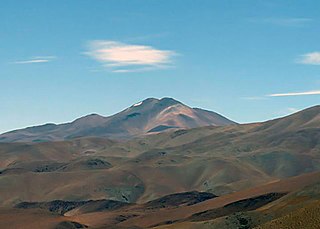
Nevado Ojos del Salado is a dormant complex volcano in the Andes on the Argentina–Chile border. It is the highest volcano on Earth and the highest peak in Chile. The upper reaches of Ojos del Salado consist of several overlapping lava domes, lava flows and volcanic craters, with an only sparse ice cover. The complex extends over an area of 70–160 square kilometres (27–62 sq mi) and its highest summit reaches an altitude of 6,893 metres (22,615 ft) above sea level. Numerous other volcanoes rise around Ojos del Salado.

Huascarán, Nevado Huascarán or Mataraju is a mountain in the Peruvian province of Yungay, situated in the Cordillera Blanca range of the western Andes. The southern summit of Huascarán, which reaches 6,768 metres (22,205 ft), is the highest point in Peru, the northern Andes, and in all of the earth's Tropics. Huascarán is the 4th highest mountain in South America after Aconcagua, Ojos del Salado, and Monte Pissis, respectively. Huascarán is ranked 25th by topographic isolation.

Cuyo is the wine-producing, mountainous region of central-west Argentina. Historically it comprised the provinces of San Juan, San Luis and Mendoza. The modern New Cuyo includes both Cuyo proper and the province of La Rioja. New Cuyo is a political and economic macroregion, but culturally La Rioja is part of the North-West rather than of Cuyo.

Cerro Mercedario is the highest peak of the Cordillera de la Ramada range and the eighth-highest mountain of the Andes. It is located 100 km to the north of Aconcagua, in the Argentine province of San Juan.

Tupungato, one of the highest mountains in the Americas, is a massive Andean lava dome dating to Pleistocene times. It lies on the Argentina–Chile border, between the Chilean Metropolitan Region and the Argentine province of Mendoza, about 100 km (62 mi) south of Aconcagua, the highest peak of both the Southern and Western hemispheres. Immediately to its southwest is the active Tupungatito volcano, which last erupted in 1987.

The Uspallata Pass, Bermejo Pass or Cumbre Pass, is an Andean pass which provides a route between the wine-growing region around the Argentine city of Mendoza, the Chilean city Los Andes and Santiago, the Chilean capital situated in the central Chilean valley.

The Southern Patagonian Ice Field, located at the Southern Patagonic Andes between Chile and Argentina, is the world's second largest contiguous extrapolar ice field. It is the bigger of two remnant parts of the Patagonian Ice Sheet, which covered all of southern Chile during the last glacial period, locally called the Llanquihue glaciation.

Dr Paul Güssfeldt was a German geologist, mountaineer and explorer.
Nevado Queva or Quewar is a volcano in the Andes mountain range of South America, located in the Salta Province of Argentina. Queva has a summit elevation of 6,140 metres (20,144 ft) above sea level. Its name is alternately spelled Quehuar. There are extensive pre-Columbian ruins on the summit of the mountain, which is a broad crater.

The Cordillera de la Ramada (Spanish for "Range of the Shelter", also called Cordón de la Ramada, in which cordón means 'ribbon' or 'rope', is a mountain range in the San Juan province of Argentina, forming part of the Andes. Its highest peak is Mercedario at 6,720 metres.
Konstanty Jodko-Narkiewicz, also known as Konstanty Narkiewicz-Jodko (1901–1963), was a Polish geophysicist who specialized in studying cosmic radiation. He was also a mountaineer, Arctic explorer, and balloonist.

Cerro La Mesa or La Mesa or Cerro de la Mesa is a mountain in the Cordillera de la Ramada range of the Andes, in Argentina. It has a height of 6,180 metres (20,276 ft). La Mesa means table in Spanish. The name of the mountain comes its flat and long summit ridge. Despite the dry climate of the area, there are significant glaciers flowing down the southern and the eastern flank of the mountain. Its slopes are within the administrative boundaries of the Argentinean city of Calingasta, Province of San Juan.
María Constanza Ceruti is an anthropologist and mountaineer from Argentina, who has done more than 80 field surveys, most of them as part of National Geographic teams in Andean regions of Argentina, Chile, Bolivia, Ecuador and Peru. Her most important finding are the Children of Llullaillaco, considered the best preserved mummies in the world by the Guinness World Records. She is also the first woman worldwide to specialize in high-altitude archaeology, studying Inca ceremonial centers on the summits of Andean peaks above 6000 meters. She is a pioneer in the anthropological study of sacred mountains around the world, and in the emerging field of glacial archaeology.

Marcos José Couch, Argentinean mountain climber, known for his professional achievements in mountains such as the Shishapangma in Tibet, or the Fitz Roy in Patagonia. Since 1987 he is a mountain guide and has been working internationally.

Principal Cordillera is the Andean mountain range that makes up the boundary between Central Chile and neighbouring areas of Argentina. It is also a continental divide between the Atlantic and the Pacific watersheds. It extends in a north–south direction in the Argentine provinces of La Rioja, San Juan and Mendoza and the Chilean regions of Valparaíso, Santiago, O'Higgins and Maule. To the east of the Principal Cordillera lies the Frontal Cordillera which is fully in Argentina. Aconcagua, the tallest mountain outside Asia, lies in the Principal Cordillera.

Polish Andean expeditions of the 1930s refers to the two expeditions of Polish mountain climbers in the Andes carried out in the 1930s.

