
The Upsala Glacier is a large valley glacier on the eastern side of the Southern Patagonian Ice Field. [1] Its higher portion lies in a disputed territory between Chile and Argentina. While the glacier flows from north to south it has three lesser eastflowing tributary glacier: Bertacchi, Cono and Murallón. [1] Each year, over 700,000 tourists visit Los Glaciares National Park, where this glacier is located, but most go to Perito Moreno glacier as it has easier accessibility. [2]
Contents
The name of this glacier comes from the old spelling with one p of Uppsala University, which sponsored the first glaciological studies in the area. The university is located in Uppsala, Sweden. [3]
The glacier terminus is at Upsala channel of Lago Argentino. [1] The Upsala Glacier is well known for its rapid retreat, [4]
Upsala Glacier exhibited almost continual recession up until 1999. The acceleration in ice motion during the two decades preceding 1999 may have been augmented by the release of backstress when the glacier retreated beyond the islands in Brazo Upsala. [5] In 2008, another period of even faster retreat started, reported as being about 10 times faster than the period recorded in the eight years prior. [6]
As of 2018 Upsala Glacier has retreated to such degree that it no longer constrain its tributary Bertacchi Glacier. Likely this makes Bertacchi Glacier have higher flow rates reflected with a subsequent stretching and thinning out of parts of the glacier as well. At parts the velocity of flow is also thought to have increased in Bertacchi Glacier as result of the near-separation from Upsala Glacier. [1] It is also worth noting that this glacier is very well known due to its large effects from climate change and how it has some of the most impacts in the world from increasing temperatures as well as changes in precipitation. [7]
- Upsala Glacier
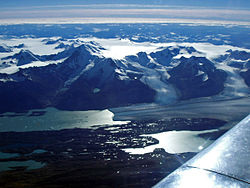 The Upsala, aerial view
 View from the Argentino Lake
 Kayaking in the Upsala Glacier


