Polvadera, New Mexico

Last updated

Polvadera, New Mexico
Usa edcp location map.svg
Red pog.svg
Polvadera, New Mexico
Location in the United States
Coordinates: 34°12′07″N106°55′02″W / 34.20194°N 106.91722°W / 34.20194; -106.91722
CountryUnited States
State New Mexico
County Socorro
Area
[1]
  Total0.97 sq mi (2.51 km2)
  Land0.97 sq mi (2.51 km2)
  Water0.00 sq mi (0.00 km2)
Elevation
[2]
4,649 ft (1,417 m)
Population
 (2020) [3]
  Total178
  Density183.69/sq mi (70.90/km2)
Time zone UTC-7 (Mountain (MST))
  Summer (DST) UTC-6 (MDT)
ZIP code
87828
Area code 575
FIPS code 35-58910
GNIS feature ID2584183 [2]

Polvadera (La Polvadera de San Lorenzo) is an unincorporated community and census-designated place in Socorro County in central New Mexico, United States. It is located on the west bank of the Rio Grande, near the mouth of the Rio Salado, and on the western spur of El Camino Real de Tierra Adentro.

Contents

Name

The name may be based upon a Piro name for the place, [4] but altered in form because polvareda means dusty in Spanish, which, as US Army Lt. Emory noted in 1846, [5] it certainly is. Other spellings of the name include Pulvidera [6] and Pulvedera. [7] The church in Polvadera was dedicated to San Lorenzo and his feast day, August 10, is the local fiesta. [8]

History

Polvadera was founded as a farming community in the 1620s after Juan de Oñate had established the province of Santa Fe de Nuevo México, when Spanish settlers came north and settled among the Piro Pueblo Indians. [9] The name of the original Piro pueblo there is unknown and its ruins, which may have been destroyed by the meandering of the Rio Grande, have not been excavated. In 1629 Apaches destroyed the pueblo of Polvareda. [10] It was subsequently rebuilt, but was abandoned as a result of the Pueblo Revolt of 1680, and because of further Apache raiding after the reconquest was not resettled again until the early 19th century after Governor Fernando Chacón reopened the area for settlement.

Apache and Navajo raids continued until after the American Civil War when the US Army began a strenuous interdiction policy. [11] The town was attacked as late as 1846 by over a hundred Navajo who made away with a large number of livestock. [12]

Camp Connelly, sometimes called Fort Connelly, [9] was established by Colonel Canby in 1862 adjacent to Polvadera, on land leased from the then governor Henry Connelly. [13] Lt. William Brady was sent there as a recruiting officer to process volunteers. [14] Camp Connelly was only maintained until the end of the civil war in 1865. [13]

The Santa Fe Railroad came through in 1882 and the Post Office in Polvadero was established in 1895. [15] The current church of San Lorenzo was built in 1898. [16]

Polvadera has always been subject to the flooding of the Rio Grande. Major floods occurred in 1898, which destroyed the church, in 1929, and 1937. [4] [17] Formerly, the major diversion of Rio Grande water for irrigation in Socorro County occurred at Polvadera; however, after the floods of 1929 a new diversion was built upstream at San Acacia. [18]

In 1958 when Interstate 25 was being built down the Rio Grande valley, Polvadera was not given an exit, the nearest exit provided was at Lemitar a few miles to the south. [19]

Economy

Polvadera is primarily a farming community. Before Prohibition, it had large areas devoted to grapes for the production of wine. [20] More recently chile has been the main crop. [9]

Demographics

Historical population
CensusPop.Note
2020 178
U.S. Decennial Census [21] [3]

Education

It is within Socorro Consolidated Schools. [22] Socorro High School is the comprehensive high school of the district.

Attractions

Nearby, to the west of the community, is San Lorenzo Canyon, a popular hiking and picnic spot. [23]

Related Research Articles

<span class="mw-page-title-main">Puebloans</span> Native Americans in the Southwestern United States

The Puebloans, or Pueblo peoples, are Native Americans in the Southwestern United States who share common agricultural, material, and religious practices. Among the currently inhabited Pueblos, Taos, San Ildefonso, Acoma, Zuni, and Hopi are some of the most commonly known. Pueblo people speak languages from four different language families, and each Pueblo is further divided culturally by kinship systems and agricultural practices, although all cultivate varieties of corn (maize).

<span class="mw-page-title-main">Rio Arriba County, New Mexico</span> County in New Mexico, United States

Rio Arriba County is a county in the U.S. state of New Mexico. As of the 2020 census, the population was 40,363. Its county seat is Tierra Amarilla. Its northern border is the Colorado state line.

<span class="mw-page-title-main">Los Ranchos de Albuquerque, New Mexico</span> Village in New Mexico, United States

Los Ranchos de Albuquerque, known locally simply as "Los Ranchos" or "The Village," is a village in Bernalillo County, New Mexico. The population was 6,024 at the time of the 2010 Census.

<span class="mw-page-title-main">Santo Domingo Pueblo, New Mexico</span> Ethnic group

Santo Domingo Pueblo, also known Kewa Pueblo is a federally-recognized tribe of Native American Pueblo people in northern New Mexico. A population of 2,456 live in structures some of which date from circa 1700; in Sandoval County described by the U.S. Census Bureau as a census-designated place.

<span class="mw-page-title-main">Socorro, New Mexico</span> City in New Mexico, United States

Socorro is a city in Socorro County in the U.S. state of New Mexico. It is in the Rio Grande Valley at an elevation of 4,579 feet (1,396 m). In 2010 the population was 9,051. It is the county seat of Socorro County. Socorro is located 74 miles (119 km) south of Albuquerque and 146 miles (235 km) north of Las Cruces.

Tiwa is a group of two, possibly three, related Tanoan languages spoken by the Tiwa Pueblo, and possibly Piro Pueblo, in the U.S. state of New Mexico.

<span class="mw-page-title-main">San Antonio, New Mexico</span>

San Antonio is a census-designated place in Socorro County, New Mexico, United States, roughly in the center of the state, on the Rio Grande.

The Pueblo Revolt of 1680, also known as Popé's Rebellion or Po'pay's Rebellion, was an uprising of most of the indigenous Pueblo people against the Spanish colonizers in the province of Santa Fe de Nuevo México, larger than present-day New Mexico. Incidents of brutality and cruelty, coupled with persistent Spanish policies that stoked animosity, gave rise to the eventual Revolt of 1680. The persecution and mistreatment of Pueblo people who adhered to traditional religious practices was the most despised of these. The Spaniards were resolved to abolish "pagan" forms of worship and replace them with Christianity. The Pueblo Revolt killed 400 Spaniards and drove the remaining 2,000 settlers out of the province. The Spaniards returned to New Mexico twelve years later.

The Piro people were a Native American tribe who lived in New Mexico during the 16th and 17th century. The Piros lived in a number of pueblos in the Rio Grande Valley around modern Socorro, New Mexico, USA. The now extinct Piro language may have been a Tanoan language. Numbering several thousand at the time of first contact with the Spanish, by the time of the Pueblo Revolt in 1680 the Piro had been decimated by European-introduced diseases and Apache attacks and most of the survivors resettled near El Paso, Texas.

Luis Lopez is an unincorporated community and census-designated place in Socorro County, New Mexico, United States. It lies between Socorro and San Antonio along the Rio Grande.

<span class="mw-page-title-main">San Miguel de Socorro</span> Historic church in New Mexico, United States

San Miguel de Socorro is the Catholic church in Socorro, New Mexico, built on the ruins of the old Nuestra Señora de Socorro mission. The old mission was built around 1627, but was destroyed in 1680 during the Pueblo Revolt. A portion of the adobe wall of the old church remains today and still can be seen behind glass just left of the altar. The building was listed on the National Register of Historic Places in 2016.

Teypana was the first pueblo to be called Socorro. This Piro pueblo was located close to present-day Socorro, New Mexico. A reference from 1598 suggests Teypana was on the west bank of the Rio Grande, downriver from the pueblo of Pilabó. Found in a partly flawed list of Piro pueblos, the reference is somewhat problematic. In 1598, Juan de Oñate and an advance party of his colonists were given food and water by the people of Teypana. In response, they named the settlement Socorro, which means “help” or “aid” in Spanish. By 1626, the name had become associated with the Piro pueblo of Pilabó, site of the first permanent mission in Piro territory, now buried under the town of Socorro, NM.

The Piro pueblo of Senecú was the southernmost occupied pueblo in New Mexico prior to the Pueblo Revolt of 1680. It was located on the west bank of the Rio Grande within sight of the Piro pueblo of San Pasqual. Colonial Spanish documents consistently place the pueblo opposite of Black Mesa, which is near San Marcial. Due to changes in the floodplain and the establishment of San Marcial, however, no surface remains of the pueblo survive in the area.

<span class="mw-page-title-main">Interstate 25 in New Mexico</span> Section of Interstate Highway in New Mexico, United States

Interstate 25 (I-25) in the US state of New Mexico follows the north–south corridor through Albuquerque and Santa Fe. It replaced U.S. Route 85 (US 85), which is no longer signed, but still exists in route logs sharing most of the I-25 alignment. I-25 starts in New Mexico at an interchange with I-10 in Las Cruces and extends roughly 460 miles (740 km) before reaching Colorado. I-25 passes through principally rural land through central New Mexico and passes through or near the cities of Las Cruces, Truth or Consequences, Socorro, Belen, Albuquerque, Santa Fe, Las Vegas, and Raton.

<span class="mw-page-title-main">New Mexico wine</span>

New Mexico has a long history of wine production, within American wine, especially along the Rio Grande, from its capital Santa Fe, the city of Albuquerque with its surrounding metropolitan area, and in valleys like the Mesilla and the Mimbres River valleys. In 1629, Franciscan friar García de Zúñiga and a Capuchín friar named Antonio de Arteaga planted the first wine grapes in Santa Fe de Nuevo México, in what would become the modern Middle Rio Grande Valley AVA. Today, wineries exist in the aforementioned Middle Rio Grande Valley, as well as the Mesilla Valley AVA and the Mimbres Valley AVA.

<span class="mw-page-title-main">Index of New Mexico–related articles</span>

The following is an alphabetical list of articles related to the U.S. state of New Mexico.

<span class="mw-page-title-main">Rio Grande Trail</span> Proposed trail in New Mexico, United States

The Rio Grande Trail is a proposed long distance trail along the Rio Grande in the U.S. state of New Mexico. The river extends over 1,800 total miles, some 700 miles (1,100 km) of which pass through the heart of New Mexico. It is the state's primary drainage feature and most valuable natural and cultural resource. The river and its bosque provide a wide variety of recreation, including hunting and fishing, birdwatching, river rafting, hiking, biking, and horseback riding. The river also flows through or beside numerous spectacular and geologically interesting landforms, the result of extensive volcanism and erosion of the valley within the Rio Grande Rift. Although some trail advocates would like to see the trail extended the full distance through New Mexico, from the Colorado border to the United States–Mexico border, the portion proposed for initial development extends 300 miles (480 km), from Bernalillo south to Las Cruces.

Tortugas, New Mexico or Tortugas Pueblo is a community in Doña Ana County, New Mexico, just outside of Las Cruces, New Mexico. As of the 2020 census, the CDP's population was 579.

San Pascual Pueblo was a Piro pueblo south and east of Socorro, in Socorro County, New Mexico, United States. Its ruins lie on the east bank of the Rio Grande, on a butte, on the western slope of the Little San Pascual Mountain, overlooking the river, near the eastern boundary of the Bosque del Apache National Wildlife Refuge.

<span class="mw-page-title-main">Rio Grande Valley (New Mexico)</span> River valley of the Rio Grande in New Mexico, United States

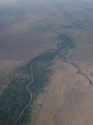
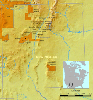
The Rio Grande Valley is the river valley carved out by the Rio Grande as it flows through the American Southwest and northeastern Mexico, forming a part of the border region. In the US state of New Mexico, the river flows mostly north to south, and forms a valley near Cochiti Pueblo to the state line near El Paso, Texas along the floors of the large sedimentary basins of the Rio Grande Rift, and includes the narrow sections between the basins. It has been historically settled first by the Pueblo peoples, the Spanish, the Mexicans, and finally Anglo-Americans. As the largest river in the state, some of its most populous cities are located wholly or partially in the valley, including Albuquerque, New Mexico's largest city.

References

  1. "ArcGIS REST Services Directory". United States Census Bureau. Retrieved October 12, 2022.
  2. 1 2 U.S. Geological Survey Geographic Names Information System: Polvadera, New Mexico
  3. 1 2 "Census Population API". United States Census Bureau. Retrieved October 12, 2022.
  4. 1 2 Harden, Paul (September 4, 2010). "Polvadera y Chamisal: Two of Socorro County's historic villages and the San Lorenzo Land Grant" (PDF). El Defensor Chieftain. Archived from the original (PDF) on July 18, 2011.
  5. Arrived at the town of Pulvidera, which we found, as its name implies, covered with dust. quoted in Marshall, Michael P. and Walt, Henry J., (1984) "Chapter 12: Post-Revolt Place Names: Polvareda" Rio Abajo: Prehistory and History of a Rio Grande Province New Mexico Historic Preservation Division, Santa Fe, p. 279, OCLC   11553460
  6. US Census of 1850
  7. US Census of 1870
  8. Pearce, T. M. (1965) "Polvadera" New Mexico place names; a geographical dictionary University of New Mexico Press, Albuquerque, NM, p. 124, OCLC 420847
  9. 1 2 3 Federal Writers’ Project (1989) "Polvareda" The WPA Guide to 1930s New Mexico University of Arizona Press, Tucson, p. 251, ISBN   0-8165-1102-0
  10. Pérez, Juan Manuel (2005) "The Hispanic Role in America: A Chronology" Coloquio Revista Cultural October 2005 Archived March 29, 2007, at the Wayback Machine , accessed February 22, 2009
  11. Kelly, Lawrence C. (1968) The Navajo Indians and Federal Indian Policy University of Arizona Press, Tucson, p. 5, ISBN   0-8165-0065-7
  12. Marshall, Michael P. and Walt, Henry J., (1984) "Chapter 12: Post-Revolt Place Names: Polvadera" Rio Abajo: Prehistory and History of a Rio Grande Province New Mexico Historic Preservation Division, Santa Fe, p. 279, OCLC   11553460
  13. 1 2 Rathburn, Daniel C. B. and Alexander, David V. (2003) "Connelly, Camp, Socorro County" New Mexico Frontier Military Place Names Yucca Tree Press, Las Cruces, New Mexico, p. 43, ISBN   1-881325-50-4
  14. Lavash, Donald R. (1986) Sheriff William Brady: Tragic Hero of the Lincoln County War Sunstone Press, Santa Fe, NM, pp. 23, ISBN   0-86534-064-1
  15. Dike, Sheldon H. (1958) The Territorial Post Offices of New Mexico Dike, Albuquerque, OCLC   10228225
  16. Harden, Paul (2007) "The Mission Churches in Socorro County – Part 2", originally published in the El Defensor Chieftain of September 8, 2007
  17. Staff (August 21, 1929) "Engineers for Conservancy District Will Investigate Fiver Needs in Flood Zone" Albuquerque Journal p. 1 col.4
  18. Wozniak, Frank E. (1987) Irrigation in the Rio Grande Valley, New Mexico: A Study of the Development of Irrigation Systems Before 1945 New Mexico Historic Preservation Division, Santa Fe, New Mexico, p. 137, OCLC   17617974
  19. Staff (October 23, 1958) "Fenced Off US 85, Village Anger Rises" Albuquerque Journal p. 1 col.3, p. 10 col. 1–5
  20. Davis, W. W. H. (1938) El Gringo: Or, New Mexico & Her People Rydal Press, Santa Fe, New Mexico, pp. 191–193 OCLC   4803385; originally published in 1857 by Harper & Brothers, New York OCLC   166604054
  21. "Census of Population and Housing". Census.gov. Retrieved June 4, 2016.
  22. "2020 CENSUS - SCHOOL DISTRICT REFERENCE MAP: Socorro County, NM" (PDF). U.S. Census Bureau . Retrieved July 14, 2022.
  23. "San Lorenzo Canyon Recreation Area" US Bureau of Land Management