Pueblo, Corozal, Puerto Rico

Last updated
Pueblo
Barrio
Barrio Pueblo, Corozal, Puerto Rico.jpg
Flowered flamboyant in Barrio Pueblo
Pueblo, Corozal, Puerto Rico locator map.png
Location of Pueblo within the municipality of Corozal shown in red
Caribbean location map.svg
Red pog.svg
Pueblo
Location of Puerto Rico
Coordinates: 18°20′46″N66°18′19″W / 18.346233°N 66.305416°W / 18.346233; -66.305416 [1]
Commonwealth Flag of Puerto Rico.svg  Puerto Rico
Municipality Corozal.svg Corozal
Area
[1]
  Total1.07 sq mi (2.8 km2)
  Land1.07 sq mi (2.8 km2)
  Water0 sq mi (0 km2)
Elevation
[2]
312 ft (95 m)
Population
 (2010)
  Total2,991
  Density2,795.3/sq mi (1,079.3/km2)
 Source: 2010 Census
Time zone UTC−4 (AST)

Pueblo is an urban barrio in the municipality of Corozal, Puerto Rico. Its population in 2010 was 2,991. [3] [4] [5]

Contents

History

Pueblo was in Spain's gazetteers [6] until Puerto Rico was ceded by Spain in the aftermath of the Spanish–American War under the terms of the Treaty of Paris of 1898 and became an unincorporated territory of the United States. In 1899, the United States Department of War conducted a census of Puerto Rico finding that the population of Pueblo was 1,057. [7]

Features and demographics

Pueblo has 1.07 square miles (2.8 km2) of land area and no water area. In 2010, its population was 2,991 with a population density of 2,795.3 inhabitants per square mile (1,079.3/km2).

Historical population
CensusPop.Note
1900 1,057
1940 308
1950 2,414683.8%
1960 2,75214.0%
1980 5,206
1990 3,953−24.1%
2000 3,639−7.9%
2010 2,991−17.8%
U.S. Decennial Census
1899 (shown as 1900) [8] 1910-1930 [9]
1930-1950 [10] 1980-2000 [11] 2010 [12]

Sectors

Barrios (which are, in contemporary times, roughly comparable to minor civil divisions) [13] in turn are further subdivided into smaller local populated place areas/units called sectores (sectors in English). The types of sectores may vary, from normally sector to urbanización to reparto to barriada to residencial, among others. [14] [15] [16]

The following sectors are in Pueblo barrio: [17]

Barriada Cuba Libre (Calle María Bou, Calle O’Neil, Calle Ramos, Calle Rivera), Calle Nieves, Sector Georgies Pizza, Sector Guayabal, Sector Idilio, Sector Kike Matos, Sector La Alcoba, Sector La Bodega, Sector La Frigo, Sector Lin Santos, Sector Los Moreno, Sector Los Torres, Sector Mario Electricista, Sector Maya Marzán, Sector Paseo del Río, Urbanización Cerromonte, Urbanización Monterrey, and Urbanización Monte Verde.

See also

Related Research Articles

<span class="mw-page-title-main">Pueblo Viejo, Guaynabo, Puerto Rico</span> Barrio of Puerto Rico

Pueblo Viejo is a barrio in the municipality of Guaynabo, Puerto Rico. Its population in 2010 was 23,816.

<span class="mw-page-title-main">Palmarejo, Corozal, Puerto Rico</span> Barrio of Puerto Rico

Palmarejo is a rural barrio with an urban zone in the municipality of Corozal, Puerto Rico. Its population in 2010 was 6,068.

<span class="mw-page-title-main">Cibuco, Corozal, Puerto Rico</span> Barrio of Puerto Rico

Cibuco is a rural barrio with an urban zone in the municipality of Corozal, Puerto Rico. Its population in 2010 was 5,387.

<span class="mw-page-title-main">Pueblo, Rincón, Puerto Rico</span> Barrio of Puerto Rico

Pueblo barrio is a barrio in the municipality of Rincón, Puerto Rico. Its population in 2010 was 3,796. There is also the administrative center and seat called Rincón barrio-pueblo in this municipality, with a smaller population.

<span class="mw-page-title-main">Pollos, Patillas, Puerto Rico</span> Barrio of Puerto Rico

Pollos is a barrio in the municipality of Patillas, Puerto Rico. Its population in 2010 was 3,146.

<span class="mw-page-title-main">Villalba Abajo</span> Barrio of Villalba, Puerto Rico

Villalba is a barrio in the municipality of Villalba, Puerto Rico. Its population in 2010 was 2,880.

<span class="mw-page-title-main">Bahomamey</span> Barrio of San Sebastián, Puerto Rico

Bahomamey is a barrio in the municipality of San Sebastián, Puerto Rico. Its population in 2010 was 2,218.

<span class="mw-page-title-main">Abras, Corozal, Puerto Rico</span> Barrio of Puerto Rico

Abras is a rural barrio with a small urban area in the municipality of Corozal, Puerto Rico. Its population in 2010 was 2,262.

<span class="mw-page-title-main">Hormigueros, Hormigueros, Puerto Rico</span> Barrio of Puerto Rico

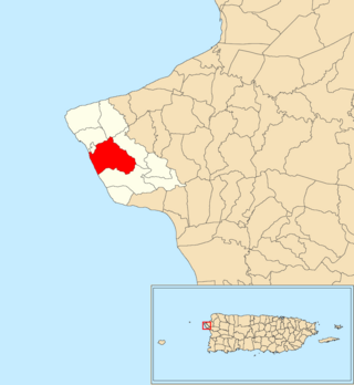
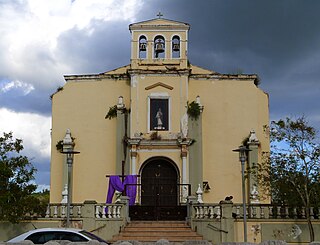
Hormigueros is a barrio in the municipality of Hormigueros, Puerto Rico. Its population in 2010 was 4,358. There is also a barrio called Hormigueros barrio-pueblo, with the administrative center and seat of this municipality.

<span class="mw-page-title-main">Toa Alta barrio-pueblo</span> Historical and administrative center (seat) of Toa Alta, Puerto Rico

Toa Alta barrio-pueblo is a barrio and the administrative center (seat) of Toa Alta, a municipality of Puerto Rico. Its population in 2010 was 397.

<span class="mw-page-title-main">Villalba barrio-pueblo</span> Historical and administrative center (seat) of Villalba, Puerto Rico

Villalba barrio-pueblo is a barrio and the administrative center (seat) of Villalba, a municipality of Puerto Rico. Its population in 2010 was 729.

<span class="mw-page-title-main">Camaceyes, Aguadilla, Puerto Rico</span> Barrio of Puerto Rico

Camaceyes is a barrio in the municipality of Aguadilla, Puerto Rico. Its population in 2010 was 12,547. In Camaceyes barrio is part of the Aguadilla urban zone.

<span class="mw-page-title-main">Corrales, Aguadilla, Puerto Rico</span> Barrio of Puerto Rico

Corrales is a rural barrio in the municipality of Aguadilla, Puerto Rico. Its population in 2010 was 7,659. In Corrales barrio is Cabán, a comunidad.

<span class="mw-page-title-main">Lares barrio-pueblo</span> Historical and administrative center (seat) of Lares, Puerto Rico

Lares barrio-pueblo is a barrio and the administrative center (seat) of Lares, a municipality of Puerto Rico. Its population in 2010 was 2,690.

<span class="mw-page-title-main">Morovis barrio-pueblo</span> Historical and administrative center (seat) of Morovis, Puerto Rico

Morovis barrio-pueblo is a barrio and the administrative center (seat) of Morovis, a municipality of Puerto Rico. Morovis barrio-pueblo has about 12 sectors and its population in 2010 was 895.

<span class="mw-page-title-main">Santana, Arecibo, Puerto Rico</span> Barrio of Puerto Rico

Santana is a barrio in the municipality of Arecibo, Puerto Rico. Its population in 2010 was 5,253.

<span class="mw-page-title-main">Corozal barrio-pueblo</span> Historical and administrative center (seat) of Corozal, Puerto Rico

Corozal barrio-pueblo is an urban barrio and the administrative center (seat) of Corozal, a municipality of Puerto Rico. Its population in 2010 was 2,631.

<span class="mw-page-title-main">Factor, Arecibo, Puerto Rico</span> Barrio of Puerto Rico

Factor is a barrio in the municipality of Arecibo, Puerto Rico. Its population in 2010 was 8,001.

<span class="mw-page-title-main">Húcares</span> Barrio of Naguabo, Puerto Rico

Húcares is a barrio in the municipality of Naguabo, Puerto Rico. Its population in 2010 was 2,918.

<span class="mw-page-title-main">Cocos, Quebradillas, Puerto Rico</span> Barrio of Puerto Rico

Cocos is a barrio in the municipality of Quebradillas, Puerto Rico. Its population in 2010 was 4,889.

References

  1. 1 2 "US Gazetteer 2019". US Census. US Government.
  2. U.S. Geological Survey Geographic Names Information System: Pueblo barrio
  3. Picó, Rafael; Buitrago de Santiago, Zayda; Berrios, Hector H. Nueva geografía de Puerto Rico: física, económica, y social, por Rafael Picó. Con la colaboración de Zayda Buitrago de Santiago y Héctor H. Berrios. San Juan Editorial Universitaria, Universidad de Puerto Rico,1969.
  4. Gwillim Law (20 May 2015). Administrative Subdivisions of Countries: A Comprehensive World Reference, 1900 through 1998. McFarland. p. 300. ISBN   978-1-4766-0447-3 . Retrieved 25 December 2018.
  5. Puerto Rico: 2010 Population and Housing Unit Counts.pdf (PDF). U.S. Dept. of Commerce, Economics and Statistics Administration, U.S. Census Bureau. 2010.
  6. "Anuario del comercio, de la industria, de la magistratura y de la administración. 1881". Biblioteca Nacional de España (in Spanish). p. 1614. Retrieved 4 April 2023.
  7. Joseph Prentiss Sanger; Henry Gannett; Walter Francis Willcox (1900). Informe sobre el censo de Puerto Rico, 1899, United States. War Dept. Porto Rico Census Office (in Spanish). Imprenta del gobierno. p.  161.
  8. "Report of the Census of Porto Rico 1899". War Department Office Director Census of Porto Rico. Archived from the original on July 16, 2017. Retrieved September 21, 2017.
  9. "Table 3-Population of Municipalities: 1930 1920 and 1910" (PDF). United States Census Bureau. Archived (PDF) from the original on August 17, 2017. Retrieved September 21, 2017.
  10. "Table 4-Area and Population of Municipalities Urban and Rural: 1930 to 1950" (PDF). United States Census Bureau. Archived (PDF) from the original on August 30, 2015. Retrieved September 21, 2014.
  11. "Table 2 Population and Housing Units: 1960 to 2000" (PDF). United States Census Bureau. Archived (PDF) from the original on July 24, 2017. Retrieved September 21, 2017.
  12. Puerto Rico: 2010 Population and Housing Unit Counts.pdf (PDF). U.S. Dept. of Commerce Economics and Statistics Administration U.S. Census Bureau. 2010. Archived (PDF) from the original on 2017-02-20. Retrieved 2019-08-02.
  13. "US Census Barrio-Pueblo definition". factfinder.com. US Census. Archived from the original on 13 May 2017. Retrieved 5 January 2019.
  14. "Agencia: Oficina del Coordinador General para el Financiamiento Socioeconómico y la Autogestión (Proposed 2016 Budget)". Puerto Rico Budgets (in Spanish). Retrieved 28 June 2019.
  15. Rivera Quintero, Marcia (2014), El vuelo de la esperanza: Proyecto de las Comunidades Especiales Puerto Rico, 1997-2004 (first ed.), San Juan, Puerto Rico Fundación Sila M. Calderón, ISBN   978-0-9820806-1-0
  16. "Leyes del 2001". Lex Juris Puerto Rico (in Spanish). Retrieved 24 June 2020.
  17. "PRECINTO ELECTORAL COROZAL 072" (PDF). Comisión Estatal de Elecciones (in Spanish). PR Government. 21 September 2019. Retrieved 24 June 2020.