
West Kalimantan is a province of Indonesia. It is one of five Indonesian provinces comprising Kalimantan, the Indonesian part of the island of Borneo. Its capital and largest city is Pontianak. It is bordered by East Kalimantan and Central Kalimantan to the east, the Malaysian state of Sarawak to the north, and the Bangka Belitung Islands to the west and the Java Sea to the south. The province has an area of 147,037 km2, and had a population of 4,395,983 at the 2010 Census and 5,414,390 at the 2020 Census; the official estimate as at mid 2023 was 5,623,328, and was projected to rise to 5,695,500 at mid 2024. Ethnic groups include the Dayak, Malay, Chinese, Javanese, Bugis, and Madurese. The borders of West Kalimantan roughly trace the mountain ranges surrounding the vast watershed of the Kapuas River, which drains most of the province. The province shares land borders with Central Kalimantan to the southeast, East Kalimantan to the east, and the Malaysian territory of Sarawak to the north.
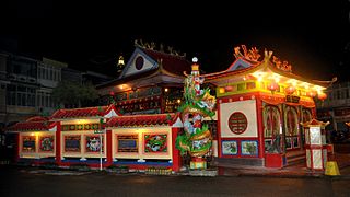
Singkawang, or San-Khew-Jong, is a coastal city and port located in the province of West Kalimantan, on the island of Borneo in Indonesia. It is located at about 145 km north of Pontianak, the provincial capital, and is surrounded by the Pasi, Poteng, and Sakkok mountains. Singkawang is derived from the Salako language, which refers to a very wide area of swamps. In addition, the ancestors of the Hakka Chinese community in Sakawokng also named this area in Hakka as "San-Khew-Jong" (Mount-Mouth-Sea), which means "A city located at the foot of a mountain near the sea and has a river that flows up to the mouth of the river (estuary)."

Pontianak, also known as Khuntien in Hakka, is the capital of the Indonesian province of West Kalimantan, founded first as a trading port on the island of Borneo, occupying an area of 118.21 km2 in the delta of the Kapuas River, at a point where it is joined by its major tributary, the Landak River. The city is on the equator, hence it is widely known as Kota Khatulistiwa. The city center is less than 3 kilometres (2 mi) south of the equator. Pontianak is the 23rd most populous city in Indonesia, and the fourth most populous city on the island of Borneo (Kalimantan) after Samarinda, Balikpapan and (Malaysia's) Kuching; it is now slightly ahead of Banjarmasin. It had a population of 658,685 at the 2020 Census within the city limits, with significant suburbs outside those limits. The official estimate as of mid-2023 was 675,468.

Kapuas Hulu Regency is a regency in West Kalimantan province of Indonesia. Located around the upper drainage area of the Kapuas River, it has a total land area of 31,318.25 square kilometres or around 21.3% of West Kalimantan province's area. The regency seat is located in town of Putussibau, where most of its economic and government activities take place. Kapuas Hulu Regency is one of the few Indonesian regencies having a land border with another country. It is also the largest regency in the province by land area. Due to its relatively large area, it is sparsely populated compared to neighbouring regencies around it. The regency had a population of 222,160 at the 2010 Census and 252,609 according to the 2020 Census; the official estimate as at mid 2023 was 262,404.
Pangsuma Airport is an airport in Putussibau, West Kalimantan, Indonesia. The distance between the Airport and Putussibau is 3.7 km via Jl. Lintas Kalimantan Poros Utara. Putussibau is the capital of Kapuas Hulu within approximately 400 km from Pontianak. The town is the gateway to the two major eco-tourism destinations in the heart of Borneo, Danau Sentarum National Park and Betung Kerihun National Park.

Sampit is a large town located in East Kotawaringin Regency, Central Kalimantan. Previously a timber port town, it has grown to be a medium-sized community with a population of 166,773 according to Statistics Indonesia in 2019, with the economy having since divested from timber products. However, the town is not an autonomous city and not an administrative division by despite having a sizeable population and urban built-up. It consists of 11 urban villages (kelurahan) from Baamang District, Seranau District, and Mentawa Baru Ketapang District. The total area of the town is 751.45 square kilometres.
Sanggau Regency is a regency in the north-central section of West Kalimantan province of Indonesia. On 18 December 2003, the regency's eastern portion was split off to create a new regency called Sekadau, leaving Sanggau with an area of 12,857.7 km2 (5,000 sq mi). As of the 2020 census, Sanggau Regency had a population of 484,836; the official estimate as at mid 2023 was 503,937. Alongside the Landak, Sekadau, and Sintang regencies, it is one of four West Kalimantan regencies with a predominantly Catholic populations.
Bakumpai or Baraki are indigenous people of Borneo and are considered as a sub-ethnic group of the Dayak Ngaju people group with Islamic background. The Bakumpai people first occupy along the Barito riverbanks in South Kalimantan and Central Kalimantan, from Marabahan to Puruk Cahu, Murung Raya Regency. The Bakumpai people first appeared as a newly recognized people group in census 2000 and were made up of 7.51% of Central Kalimantan population, which before this the Bakumpai people were considered as part of the Dayak people in a 1930 census.

Melawi River is a river in north-western Borneo, Indonesia, about 900 km northeast of the capital Jakarta. It is a tributary of the Kapuas River.

Gunung Mas Regency is one of the thirteen regencies of Central Kalimantan Province, Indonesia. The regency seat is located at the town of Kuala Kurun in Kurun District. The population area of Gunung Mas Regency is 19,894 km2, and its population was 96,990 at the 2010 census and 135,373 at the 2020 census; the official estimate as at mid 2023 was 142,835 . The regency initially existed between 1965 and 1979, after which it was a district within Kapuas Regency. Its status as a separate regency was restored on 10 April 2002 following rapid decentralization and democratization after the fall of Suharto. The regency has the 5th highest Human Development Index in the province.

Kapuas Regency is one of the thirteen regencies which divide Central Kalimantan Province, on the island of Kalimantan, Indonesia. It formerly covered a wider area, but on 10 April 2002 two further regencies were cut out of its western districts, and the residual area is now 17,070.39 km.2 Its population was 329,646 at the 2010 Census and 410,446 at the 2020 Census; the official estimate as at mid 2023 was 425,186. The administrative centre is the town of Kuala Kapuas near the coast, but the largest town is Selat, which includes 8 of the regency's 15 urban kelurahan, and had 72,382 inhabitants in mid 2023.

East Kotawaringin Regency is one of the thirteen regencies which comprise the Central Kalimantan Province on the island of Kalimantan (Borneo), Indonesia. It originally covered a much larger part of the province, having been split from a single Kotawaringin Regency on 26 June 1959 into separate regencies for East and West Kotawaringin, but on 10 April 2002 several districts in the west of the regency were split off to form the new Seruyan Regency, and several districts in the east of the regency were similarly split off to form the new Katingan Regency. The area of the residual East Kotawaringin Regency is 16,796 km2, and its population was 374,175 at the 2010 Census, and 428,900 at the 2020 Census; the official estimate as at mid 2023 was 443,359. The town of Sampit is the capital of East Kotawaringin Regency.

Sintang Regency is a regency of West Kalimantan province of Indonesia. It covers an area of 21,638.2 km2, and had a population of 364,759 at the 2010 Census and 421,306 at the 2020 Census; the official estimate as at mid 2023 was 438,022.

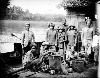
Ot Danum people are an ethnicity of the Dayak peoples dwelling at the upper reaches of south Kapuas River, and along the Schwaner range, bordering West Kalimantan and Central Kalimantan, Indonesia. They are the most important group of the upper Melawi River and culturally and linguistically the most distinct from the Malay people. Besides, the Malay people, the Ot Danum people are also linguistically distinct from the Ngaju people who live along the middle reaches of Central Kalimantan's great rivers and who are numerically and linguistically the dominant Dayak people group in the area. Just like most Dayak people group, majority of the Ot Danum people also practice Kaharingan religion.

Bahau people is a sub-ethnic group of the Dayak people who inhabit West Kutai Regency (9.3%), East Kalimantan, Indonesia.
The Dayak Desa War or Majang Desa War was an armed uprising by the Dayak Desa tribe in West Kalimantan against the Japanese Empire during World War II, and shortly thereafter by Indonesian nationalists against the Dutch East Indies. The war was initially caused by the local population's opposition against the rōmusha system and disappointment with Japanese occupation. In the initial phase of Japanese occupation, several Japanese companies entered the region to gain natural resources in order to support the Japanese war effort in the Pacific. Occupying Japanese forced locals to work for free for these companies, mainly in coal mining and timber production. After that, a Japanese foreman working in a company wanted to marry the daughter of Pang Linggan, a respected Dayak chief in the region, which caused more tension between locals and the Japanese. Dayak tribes in the region initiated mangkuk merah ritual, as a sign to mobilise men from villages and prepare for war. The Japanese were driven out of the Borneo interior in June 1945, but returned on 17 July and continued until 31 August 1945 when Japanese forces there surrendered and left the region, replaced by Allied forces including the Dutch, who would later be opposed again until recognition of Indonesian independence in 1949.

Kuala Kapuas is the regency seat of Kapuas Regency and also one of the major towns in Central Kalimantan. This town is at a distance of 137 km northeast of Palangka Raya city, the capital of Central Kalimantan Province. The area of this town is mainly situated within six urban villages (kelurahan) and two rural districts (desa) in the district of Selat i.e. the kelurahan of Selat Barat, Selat Dalam, Selat Tengah, Selat Hulu, Selat Hilir and Selat Utara, and the desa of Pulau Telo, and Pulau Telo Baru. The total population of Kuala Kapuas as of 2019 was approximately 55,573 people
South Putussibau is a district (kecamatan) located in Kapuas Hulu Regency, West Kalimantan, Indonesia. It is situated in the northeastern part of the regency and is part of the larger West Kalimantan province.
North Putussibau is a district (kecamatan) located in Kapuas Hulu Regency, West Kalimantan, Indonesia.


