Kabul is the capital city of Afghanistan. Located in the eastern half of the country, it is also a municipality, forming part of the Kabul Province. The city is divided for administration into 22 municipal districts. In 2025 its population is estimated to be 6.74 million people. In contemporary times, Kabul has served as Afghanistan's political, cultural and economical center. Rapid urbanisation has made it the country's primate city and the 75th-largest city in the world.
Jaghori is one of the main districts of the Ghazni province in Afghanistan. It is located in the highlands in the southern fringes of the Hazaristan region. It occupies 1,855 km2. in the upper Arghandab valley. The population is estimated to be around 560,000 in 2015. The district capital, Sange-e-Masha, is where major business transactions take place. The district is heavily dependent on agriculture, and migrant workers as the main sources of income. Other major marketplaces are in Ghojor and Anguri.

Qarabagh District is located 50 kilometers north of Kabul City in Afghanistan, and 20 kilometers southeast of Bagram Airbase. The district is part of Kabul Province and is on the route between Kabul and Parwan Province. It has a population of 15,000, with an expected 19,000 more refugees to return from Pakistan and Iran in the future. As of 2002 around 60% of the population are Tajiks and 40% Pashtuns.
Malistan or Malestan, is a district in Ghazni province, Afghanistan. Its population, which is 100% Hazara, was estimated at 350,000 in 2009. The district capital is Mir Adina.

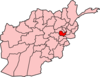
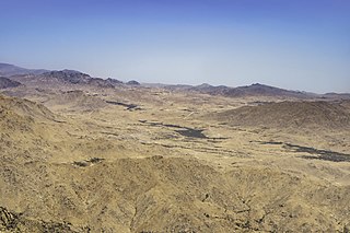
Qarabagh or Qara Bagh, is a district in Ghazni province, 56 km to the south-west of Ghazni city in eastern Afghanistan. The 1,800 km2 area is one of the most populated at 109,000; some reports count more than 218,000. The ethnic composition of the district includes Hazaras and Pashtuns. The landscape varies in different parts of the district - deserts in the southwest, plains in the southeast and mountains in the north. The district is seriously affected by drought, especially farming and animal husbandry. Health and education need serious improvement.
Qarabagh is a town located in Afghanistan. It is the administrative center of Qarabagh District, Ghazni Province. Also a district in Kabul is named Qarabagh too.

Deh Sabz District, also romanized Dih Sabz District, is situated northeast of Kabul city in Afghanistan. It has a population of 100,136 people, about 70% of it Pashtun and 30% Tajiks.

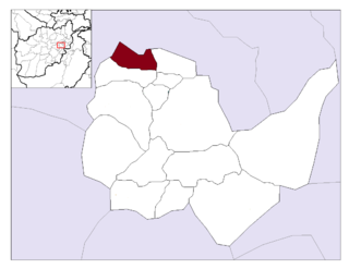
Guldara District is located in the northwestern part of Kabul Province, Afghanistan. It has a population of 25,213 people, including new returnees from Iran and Pakistan who had fled there during various stages of conflict in Afghanistan. Around 70% are Tajiks and 30% Pashtuns.
Istalif District is located in the northwestern part of Kabul Province, Afghanistan. It has a population of 8,500, a mixture of Tajiks, Pashtuns and Hazaras.

Kalakan District is located in the northern part of Kabul Province, Afghanistan. It borders Guldara District to the west, Qarabagh District to the north, Dih Sabz District to the east and Mir Bacha Kot District to the south. The population is 26,800 (2006). Tajiks form the majority of population. The center is the village of Kalakan, situated in the central part of the district. The district has been seriously affected by war. Most infrastructure was destroyed. The reconstruction and the return of the displaced families is a slow process.
Farza District, also referred to as Farza, is district of Kabul Province, Afghanistan, with a population of 18,000 people. It's located 45 km north of Kabul, in the hills of the northwestern part of the Shomali Plain, and south of the villages of Istalif and Qarabagh. Farza District contains eighteen villages. The district headquarters is Dehnawe Farza. According to the UNHCR, in 2002, the population consisted of a mixture of Pashtuns and Tajiks.

Bagh-e Babur, also known as Gardens of Babur, is a historic site in Chelsatun, Kabul, Afghanistan. It is located in the Sher Darwaza hillside of District 5, southwest of Shahr-e Naw, or a short distance south of Kabul Zoo and north of Chihil Sutun. The gardens of Babur has several terraced buildings, a small mosque, and plenty of walking space. Visited by up to one million locals and foreign tourists a year, it is also where the tomb of the first Mughal emperor Babur is located. The park is thought to have been developed around 1504, when Babur gave orders for the construction of an "avenue garden" in Kabul, described in some detail in his memoirs, the Baburnama. It has been re-developed by various Afghan rulers since then.

Ramazan Bashardost is an Afghan politician who was the former planning minister in Afghanistan and a former member of the National Assembly of Afghanistan. He was an independent candidate in the 2009 Afghan presidential election.
Karabakh is a geographic region in present-day eastern Armenia and southwestern Azerbaijan, extending from the highlands of the Lesser Caucasus down to the lowlands between the rivers Kura and Aras

Kholm or Khulm, formerly known as Tashqurghan, is a town in Samangan Province of northern Afghanistan, 60 km east of Mazar-i-Sharif one-third of the way to Kunduz. Kholm is an ancient town located on the fertile, inland delta fan of the Khulm River. As such, it is an agriculturally rich locale and densely populated. It is famous for its covered market, and is a centre for trading in sheep and wood.
Tourism in Afghanistan is regulated by the Ministry of Information and Culture. There are at least 350 tourism companies operating in Afghanistan. Tourism was at its peak before the 1978 Saur Revolution, which was followed by the decades of warfare. Between 2013 and 2016, Afghan embassies issued between 15,000 and 20,000 tourist visas annually. Following Taliban's return to power in August 2021, visitor numbers gradually increased from 691 in 2021 to 2,300 in 2022, reaching 7,000 in 2023.

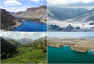
Afghanistan, which is about two-thirds mountainous, contains many valleys. The majority of the valleys are located in parts of northeastern, central, southern and southeastern Afghanistan. The southeastern areas are wetter and are covered by forest with trees such as cypress, oak, poplar, pine etc. The valleys are the most populated regions in the country, and much of the agriculture done takes place either in the valleys or on the high plains.
Anwar Khan Auriakhel is a citizen of Afghanistan and a former representative to the Wolesi Jirga, the lower house of its national legislature. He was elected to represent Kabul Province in 2005.
Events in the year 2017 in Afghanistan.
Qarabaghi or Qara Baghi is a Hazara tribe in Afghanistan and Pakistan that originates from the Qarabagh district of Ghazni province in Afghanistan.