Quail, Texas

Last updated

Quail, Texas
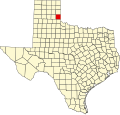
TXMap-doton-Quail.PNG
Location of Quail, Texas
Collingsworth County Quail.svg
Coordinates: 34°54′54″N100°23′30″W / 34.91500°N 100.39167°W / 34.91500; -100.39167
Country United States
State Texas
County Collingsworth
Area
  Total3.2 sq mi (8.2 km2)
  Land3.2 sq mi (8.2 km2)
  Water0.0 sq mi (0.0 km2)
Elevation
[1]
2,225 ft (678 m)
Population
 (2020)
  Total17
  Density5.4/sq mi (2.1/km2)
Time zone UTC-6 (Central (CST))
  Summer (DST) UTC-5 (CDT)
ZIP code
79251
Area code 806
FIPS code 48-60020 [2]
GNIS feature ID2409112 [1]

Quail is a rural small town and census-designated place in Collingsworth County, Texas, United States. The population was 17 at the 2020 census, down from 19 at the 2010 census. [3] The town has a general store, a small hotel and an income tax service.

Contents

Geography

Quail is located in west-central Collingsworth County along Texas State Highway 203. It is 14.2 miles (22.9 km) northwest of Wellington, the county seat, and 16 miles (26 km) east of Hedley.

According to the United States Census Bureau, the Quail CDP has a total area of 3.2 square miles (8.2 km2), all land. [3]

Demographics

Historical population
CensusPop.Note
2000 33
2010 19−42.4%
2020 17−10.5%
U.S. Decennial Census [4]
1850–1900 [5] 1910 [6]
1920 [7] 1930 [8] 1940 [9]
1950 [10] 1960 [11] 1970 [12]
1980 [13] 1990 [14] 2000 [15]
2010 [16]

As of the census [2] of 2000, there were 33 people, 11 households, and 9 families residing in the CDP. The population density was 10.4 people per square mile (4.0/km2). There were 16 housing units at an average density of 5.0/sq mi (1.9/km2). The racial makeup of the CDP was 75.76% White, 3.03% African American and 21.21% Native American.

There were 11 households, out of which 36.4% had children under the age of 18 living with them, 90.9% were married couples living together, and 9.1% were non-families. 9.1% of all households were made up of individuals, and 9.1% had someone living alone who was 65 years of age or older. The average household size was 3.00 and the average family size was 3.10.

In the CDP, the population was spread out, with 24.2% under the age of 18, 12.1% from 18 to 24, 21.2% from 25 to 44, 21.2% from 45 to 64, and 21.2% who were 65 years of age or older. The median age was 38 years. For every 100 females, there were 175.0 males. For every 100 females age 18 and over, there were 150.0 males.

The median income for a household in the CDP was $19,464, and the median income for a family was $19,464. Males had a median income of $30,000 versus $26,250 for females. The per capita income for the CDP was $13,456. None of the population or families were below the poverty line.

Education

Quail is served by the Hedley Independent School District.

Related Research Articles

<span class="mw-page-title-main">Pettus, Texas</span> Census-designated place in Texas, United States

Pettus is a census-designated place (CDP) in Bee County, Texas, United States. The population was 449 at the 2020 census.

<span class="mw-page-title-main">Scenic Oaks, Texas</span> Census-designated place in Texas, United States

Scenic Oaks is a census-designated place (CDP) in Bexar County, Texas, United States. It is part of the San Antonio Metropolitan Statistical Area. The population was 10,458 at the 2020 census, up from 4,957 at the 2010 census.

<span class="mw-page-title-main">Bixby, Texas</span> CDP in Texas, United States

Bixby is a census-designated place (CDP) in Cameron County, Texas, United States. The population was 352 at the 2020 census. It is part of the Brownsville–Harlingen Metropolitan Statistical Area.

<span class="mw-page-title-main">Cameron Park, Texas</span> CDP in Texas, United States

Cameron Park is a census-designated place (CDP) in Cameron County, Texas, United States. The population was 6,099 at the 2020 census. It is part of the Brownsville–Harlingen Metropolitan Statistical Area.

<span class="mw-page-title-main">Green Valley Farms, Texas</span> Census-designated place in Texas, United States

Green Valley Farms is a census-designated place (CDP) in Cameron County, Texas, United States. The population was 655 at the 2020 census, down from 1,272 at the 2010 census. It is part of the Brownsville–Harlingen Metropolitan Statistical Area.

<span class="mw-page-title-main">La Feria North, Texas</span> Census-designated place in Texas, United States

La Feria North is a census-designated place (CDP) in Cameron County, Texas, United States. The population was 225 at the 2020 census. It is part of the Brownsville–Harlingen Metropolitan Statistical Area.

<span class="mw-page-title-main">San Pedro, Texas</span> Census-designated place in Texas, United States

San Pedro is a census-designated place (CDP) in Cameron County, Texas, United States. The population was 442 at the 2020 census. It is part of the Brownsville–Harlingen Metropolitan Statistical Area.

<span class="mw-page-title-main">Solis, Texas</span> Census-designated place in Texas, United States

Solis is a census-designated place (CDP) in Cameron County, Texas, United States. The population was 722 at the 2020 census. It is part of the Brownsville–Harlingen Metropolitan Statistical Area.

<span class="mw-page-title-main">Samnorwood, Texas</span> Census-designated place in Texas, United States

Samnorwood is a census-designated place (CDP) in Collingsworth County, Texas, United States. It was designated in or after 1980. The population was 24 at the 2020 census, down from 51 at the 2010 census. The hamlet of Samnorwood, for which the CDP was named, is located within the CDP.

<span class="mw-page-title-main">Canutillo, Texas</span> Census-designated place in Texas, United States

Canutillo is a census-designated place (CDP) in El Paso County, Texas, United States. The population was 6,321 at the 2010 census. It is part of the El Paso Metropolitan Statistical Area. The ZIP Codes encompassing the CDP area are 79835 and 79932.

<span class="mw-page-title-main">Cumings, Texas</span> Census-designated place in Texas, United States

Cumings is an unincorporated community and census-designated place (CDP) in Fort Bend County, Texas, United States. The population was 2,207 at the 2020 census, significantly up from 981 at the 2010 census.

<span class="mw-page-title-main">Indian Hills, Texas</span> Census-designated place in Texas

Indian Hills is a census-designated place (CDP) in Hidalgo County, Texas, United States. At the 2020 United States Census, the population was 2,694. It is part of the McAllen–Edinburg–Mission Metropolitan Statistical Area.

<span class="mw-page-title-main">Monte Alto, Texas</span> Census-designated place in Texas

Monte Alto is a census-designated place (CDP) in Hidalgo County, Texas, United States. The population was 1,930 at the 2020 census. It is part of the McAllen–Edinburg–Mission Metropolitan Statistical Area.

<span class="mw-page-title-main">Relampago, Texas</span> Census-designated place in Texas

Relampago is a census-designated place (CDP) in Hidalgo County, Texas, United States. The population was 129 at the 2020 United States Census. It is part of the McAllen–Edinburg–Mission Metropolitan Statistical Area.

<span class="mw-page-title-main">South Alamo, Texas</span> Census-designated place in Texas

South Alamo is a census-designated place (CDP) in Hidalgo County, Texas, United States. The area is known locally as "Little Mex (Mexico)". The population was 3,414 at the 2020 United States Census. It is part of the McAllen–Edinburg–Mission Metropolitan Statistical Area.

<span class="mw-page-title-main">K-Bar Ranch, Texas</span> Census-designated place in Texas, United States

K-Bar Ranch is a census-designated place (CDP) in Jim Wells County, Texas, United States. The population was 375 at the 2020 census.

<span class="mw-page-title-main">Garceno, Texas</span> CDP in Texas, United States

Garceno is a census-designated place (CDP) in Starr County, Texas, United States. The population was 440 at the 2020 census, an increase from the figure of 420 tabulated in 2010.

<span class="mw-page-title-main">Los Alvarez, Texas</span> CDP in Texas, United States

Los Alvarez is a census-designated place (CDP) in Starr County, Texas, United States. The population was 303 at the 2010 census, a decline from the figure of 1,434 tabulated in 2000.

<span class="mw-page-title-main">Elbert, Texas</span> CDP in Texas, United States

Elbert is a census-designated place (CDP) in Throckmorton County, Texas, United States. The population was 29 at the 2020 census.

<span class="mw-page-title-main">Siesta Shores, Texas</span> CDP in Texas, United States

Siesta Shores is a census-designated place (CDP) in Zapata County, Texas, United States. The population was 1,450 at the 2020 census.

References

  1. 1 2 U.S. Geological Survey Geographic Names Information System: Quail, Texas
  2. 1 2 "U.S. Census website". United States Census Bureau . Retrieved January 31, 2008.
  3. 1 2 "Geographic Identifiers: 2010 Census Summary File 1 (G001): Quail CDP, Texas". U.S. Census Bureau, American Factfinder. Archived from the original on February 13, 2020. Retrieved August 4, 2015.
  4. "Decennial Census by Decade". United States Census Bureau .
  5. "1900 Census of Population - Population of Texas By Counties And Minor Civil Divisions" (PDF). United States Census Bureau .
  6. "1910 Census of Population - Supplement for Texas" (PDF). United States Census Bureau .
  7. "1920 Census of Population - Number of Inhabitants - Texas" (PDF). United States Census Bureau .
  8. "1930 Census of Population - Number of Inhabitants - Texas" (PDF). United States Census Bureau .
  9. "1940 Census of Population - Number of Inhabitants - Texas" (PDF). United States Census Bureau .
  10. "1950 Census of Population - Number of Inhabitants - Texas" (PDF). United States Census Bureau .
  11. "1960 Census of Population - Number of Inhabitants - Texas" (PDF). United States Census Bureau .
  12. "1970 Census of Population - Number of Inhabitants - Texas" (PDF). United States Census Bureau .
  13. "1980 Census of Population - Number of Inhabitants - Texas" (PDF). United States Census Bureau .
  14. "1990 Census of Population - Population and Housing Unit Counts - Texas" (PDF). United States Census Bureau .
  15. "2000 Census of Population - Population and Housing Unit Counts - Texas" (PDF). United States Census Bureau .
  16. "2010 Census of Population - Population and Housing Unit Counts - Texas" (PDF). United States Census Bureau .