Quebrada Arenas | |
|---|---|
Barrio | |
| Puerto Rico Highway 198 between Montones and Quebrada Arenas | |
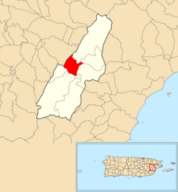
| Location of Quebrada Arenas within the municipality of Las Piedras shown in red | |
| Coordinates: 18°11′55″N65°52′30″W / 18.198652°N 65.87499°W [1] | |
| Commonwealth | |
| Municipality | |
| Area | |
• Total | 1.93 sq mi (5.0 km2) |
| • Land | 1.93 sq mi (5.0 km2) |
| • Water | 0 sq mi (0 km2) |
| Elevation | 351 ft (107 m) |
| Population (2010) | |
• Total | 4,225 |
| • Density | 2,200.5/sq mi (849.6/km2) |
| Source: 2010 Census | |
| Time zone | UTC−4 (AST) |
| ZIP Code | 00771 |
Quebrada Arenas is a barrio in the municipality of Las Piedras, Puerto Rico. Its population in 2010 was 4,225. [3] [4] [5]
Quebrada Arenas was in Spain's gazetteers [6] until Puerto Rico was ceded by Spain in the aftermath of the Spanish–American War under the terms of the Treaty of Paris of 1898 and became an unincorporated territory of the United States. In 1899, the United States Department of War conducted a census of Puerto Rico finding that the population of Quebrada Arena barrio and Pueblo barrio was 1,449. [7]
| Census | Pop. | Note | %± |
|---|---|---|---|
| 1900 | 721 | — | |
| 1910 | 404 | −44.0% | |
| 1920 | 466 | 15.3% | |
| 1930 | 759 | 62.9% | |
| 1940 | 810 | 6.7% | |
| 1950 | 896 | 10.6% | |
| 1960 | 966 | 7.8% | |
| 1970 | 0 | −100.0% | |
| 1980 | 1,217 | — | |
| 1990 | 2,275 | 86.9% | |
| 2000 | 4,386 | 92.8% | |
| 2010 | 4,225 | −3.7% | |
| U.S. Decennial Census 1899 (shown as 1900) [8] 1910-1930 [9] 1930-1950 [10] 1980-2000 [11] 2010 [12] | |||