
Blackfriars Bridge is a road and foot traffic bridge over the River Thames in London, between Waterloo Bridge and Blackfriars Railway Bridge, carrying the A201 road. The north end is in the City of London near the Inns of Court and Temple Church, along with Blackfriars station. The south end is in the London Borough of Southwark, near the Tate Modern art gallery and the Oxo Tower. Opened in the 1860s, it replaced an earlier bridge from the 1760s.

Perth is a centrally located Scottish city, on the banks of the River Tay. It is the administrative centre of Perth and Kinross council area and is the historic county town of Perthshire. It had a population of about 47,430 in 2018.

Holborn Viaduct is a road bridge in London and the name of the street which crosses it. It links Holborn, via Holborn Circus, with Newgate Street, in the City of London, England financial district, passing over Farringdon Street and the subterranean River Fleet. The viaduct spans the steep-sided Holborn Hill and the River Fleet valley at a length of 1,400 feet (430 m) and 80 feet (24 m) wide. City surveyor William Haywood was the architect and the engineer was Rowland Mason Ordish.

The Narrows Bridge is a freeway and railway crossing of the Swan River in Perth, Western Australia.

The Causeway is an arterial traffic crossing in Perth, Western Australia, linking the inner-city suburbs of East Perth and Victoria Park. It is carried over the Swan River at the eastern end of Perth Water by two bridges on either side of Heirisson Island. The current Causeway is the third structure to have been built across the river at this point.

Canning Highway is an arterial road in Perth, Western Australia, linking the inner Perth suburb of Victoria Park in the north-east, to the port city of Fremantle in the south-west.

Loch Tummel is a long, narrow loch, seven kilometres northwest of Pitlochry in the council area of Perth and Kinross, Scotland. It is fed and drained by the River Tummel, which flows into the River Tay about 13 km (8 mi) south-east of the Clunie Dam at the loch's eastern end.

Dunkeld is a town in Perth and Kinross, Scotland. The location of a historic cathedral, it lies on the north bank of the River Tay, opposite Birnam. Dunkeld lies close to the geological Highland Boundary Fault, and is frequently described as the "Gateway to the Highlands" due to its position on the main road and rail lines north. Dunkeld has a railway station, Dunkeld & Birnam, on the Highland Main Line, and is about 25 kilometres north of Perth on what is now the A9 road. The main road formerly ran through the town, however following modernisation of this road it now passes to the west of Dunkeld.

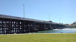
Canning Bridge is a traffic bridge which is the most downstream crossing of the Canning River in the city of Perth, Western Australia. The bridge is a part of Canning Highway, and it connects the suburbs of Como and Applecross. The Canning River is approximately 100 metres wide at the crossing, the narrowest point of the river along its downstream stretch. It is located near the Canning Bridge railway station.

Victoria Park is an inner south eastern suburb of Perth, Western Australia. Its local government area is the Town of Victoria Park.
Queen Victoria Street is the main road entering the city centre of Fremantle, Western Australia from the direction of Perth. The road was originally named Cantonment Road, but was subsequently renamed Victoria Road, and a few years later Queen Victoria Street, after Queen Victoria of the United Kingdom, to avoid confusion with similarly named roads in the area.

The Port of Hull is a port at the confluence of the River Hull and the Humber Estuary in Kingston upon Hull, in the East Riding of Yorkshire, England.

The Royal Arch was a structure erected in Dundee, Scotland, between 1849 and 1853 and demolished in 1964. The monumental archway formerly stood over the access to the pier between Earl Grey Dock and King William IV Dock on the city's waterfront.

Perth Bridge is a toll-free bridge in the city of Perth, Scotland. A Category A listed structure, it spans the River Tay, connecting Perth, on the western side of the river, to Bridgend, on its eastern side, carrying both automotive and pedestrian traffic of West Bridge Street. An earlier bridge was demolished at the same location in 1621, and many unsuccessful attempts were made to replace it. A subscription was started by James VI and several noblemen to help with the construction cost, but the king's death in 1625 suspended the scheme and a series of ferryboats were instead used.

North Inch is a large public park in Perth, Scotland. About 57 hectares in size, it is one of two "Inches" in Perth, the other being the smaller, 31-hectare South Inch, located half a mile across the city. The inches were granted to the city, when it was a royal burgh, by King Robert II in 1374. Both inches were once islands in the River Tay; today, they are connected by Tay Street, part of the A989.

Victoria Bridge is a category A listed road bridge spanning the River Clyde in Glasgow, Scotland. Victoria Bridge is the oldest surviving bridge in Glasgow, lying at the foot of Stockwell Street in the city centre.

The Albert Bridge is a road bridge that spans the River Clyde in Glasgow, Scotland, near Glasgow Green. The bridge opened in 1871. It links the Saltmarket in the city centre with Crown Street on the city’s south side. It is category A listed, and named after Queen Victoria's consort, Prince Albert.

Tay Street is a major thoroughfare, part of the A989, in the Scottish city of Perth, Perth and Kinross. Planned in 1806 and completed around 1885, it is named for the River Tay, Scotland's longest river, on the western banks of which it sits. The street runs from the confluence of West Bridge Street and Charlotte Street in the north to a roundabout at Marshall Place and Shore Road in the south. Three of the city's four bridges that cross the Tay do so in this stretch : Perth Bridge, Queen's Bridge and the single-track Tay Viaduct, carrying Perth and Dundee trains to and from Perth railway station, located 0.5 miles (0.80 km) to the north-west.

South Street is a prominent street in the Scottish city of Perth, Perth and Kinross. Established in at least the 15th century, it runs for about 0.5 miles (0.80 km), from the Dundee Road in the east to County Place in the west, passing through the entire breadth of the city. Queen's Bridge, completed in 1960 and opened by Queen Elizabeth II, carries South Street across the River Tay to and from Kinnoull.


