
Goat Island Light is a lighthouse located off Cape Porpoise near Kennebunkport in southern Maine. Goat Island Light was established in 1835 to guard the entrance to Cape Porpoise Harbor. The original station was upgraded in 1859 to the current brick tower with a fifth order Fresnel lens. Keeper's quarters were added to the island in 1860. The light station was automated by the United States Coast Guard in 1990 and is currently active. The keepers dwellings and tower are leased to the Kennebunkport Conservation Trust. Goat Island Light can be seen from shore in Cape Porpoise Harbor just off State Route 9 north of Kennebunkport or is viewable by boat. The island is currently closed to the public except by special arrangement.

Annisquam Harbor Light Station is a historic lighthouse on Wigwam Point in the Annisquam neighborhood of Gloucester, Massachusetts. It can be viewed from nearby Wingaersheek Beach, Gloucester. It lies on the Annisquam River and is one of the four oldest lighthouses to surround the Gloucester peninsula as well as; Eastern Point Light, Ten Pound Island Light, and Thacher Island Light.

The Burnt Island Light, built in 1821, is the second oldest surviving lighthouse in Maine. It hosts a living history museum run by the state Department of Marine Resources. It was added to the National Register of Historic Places as Burnt Island Light Station on November 23, 1977.
Damariscove is an uninhabited island that is part of Boothbay Harbor in Lincoln County, Maine, United States, approximately 5 nautical miles (9.3 km) off the coast at the mouth of the Damariscotta River. The long, narrow island is approximately 2 miles (3.2 km) long and 1,500 feet (460 m) at its widest point. The island has served in the past as a fishing settlement and a United States Coast Guard life saving station.

The Doubling Point Range Lights are a pair of range lights on the Kennebec River, in Arrowsic, Maine. Built in 1898 as part of a major improvement on navigational aids on the river, they are the only surviving pair of range lights in the state. They were listed on the National Register of Historic Places as Kennebec River Light Station on January 21, 1988.

Doubling Point Light is a lighthouse on the Kennebec River in Arrowsic, Maine. It was established in 1898, fifteen years after the founding of the Bath Iron Works, a major shipbuilder, 1.5 miles (2.4 km) upriver. It was part of a major upgrade of the river's lights — the Doubling Point Light and the separate Range Lights on the point, Perkins Island Light, and Squirrel Point Light were all built at the same time. The light was listed on the National Register of Historic Places as Doubling Point Light Station on January 21, 1988. It remains an active aid to navigation.

Bear Island Light is a lighthouse on Bear Island near Mt. Desert Island, at the entrance to Northeast Harbor, Maine. It was first established in 1839. The present structure was built in 1889. It was deactivated in 1981 and relit as a private aid to navigation by the Friends of Acadia National Park in 1989. Bear Island Light was listed on the National Register of Historic Places as Bear Island Light Station on March 14, 1988.

The Burnt Coat Harbor Light Station is a lighthouse on Swan's Island, Maine. It is located on Hockamock Head, at the entrance to Burnt Coat Harbor and at the end of Harbor Road. Hockamock Head is a peninsula extending south from the center of the island, dividing the island's main harbor from Toothacker Bay. The light marks the entrance to Burnt Coat Harbor. It was built in 1872, and is a well-preserved 19th-century light station. It was listed on the National Register of Historic Places in 1988.
Curtis Island Light, originally Negro Island Light, is a lighthouse marking the approach to the harbor of Camden, Maine. It is located on Curtis Island, which shelters the harbor from ocean storms. It was first established in 1835, and the present structure was built in 1896. The light was automated in 1972, and listed on the National Register of Historic Places in 1973.

Egg Rock Light is a lighthouse on Frenchman Bay, Maine. Built in 1875, it is one of coastal Maine's architecturally unique lighthouses, with a square tower projecting through the square keeper's house. Located on Egg Rock, midway between Mount Desert Island and the Schoodic Peninsula, it is an active aid to navigation, flashing red every 40 seconds. The light was listed on the National Register of Historic Places as Egg Rock Light Station in 1988.

Grindel Point Light is a lighthouse in Islesboro, Maine, marking the west entrance to Gilkey Harbor at the westernmost point of the eponymous island. The light station was established in 1850, and the present tower and keeper's house were built in 1874. The station was deactivated in 1934 and reactivated in 1987. It was listed on the National Register of Historic Places in 1987. The keeper's house now houses the Grindel Point Sailor's Museum and the lighthouse tower is open for tours in the summer.

Hendricks Head Light is a lighthouse in Southport, Maine marking the west side of the mouth of the Sheepscot River. The light station was established in 1829, and its present structures date to 1875. It was deactivated in 1933, but relit in 1951. The two-story wood keeper's house is now a private summer residence. The light is on continuously, showing white to the west and red to the east. It was listed on the National Register of Historic Places as Hendricks Head Light Station on November 20, 1987.

Heron Neck Light is a lighthouse on Green's Island in Vinalhaven, Maine at the south end of Penobscot Bay. It was established in 1854 as an aid to navigation for Vinalhaven's main port, and for the Hurricane Channel extending northwest from Heron's Neck. The light was automated in 1984. It was listed on the National Register of Historic Places as Heron Neck Light Station on January 21, 1988.

Perkins Island Light is a lighthouse on the Kennebec River in Maine. It was established in 1898, as part of a major upgrade of the river's lights — the Doubling Point Light and the separate Range Lights on the point, Perkins Island Light, and Squirrel Point Light were all built at the same time. It was listed on the National Register of Historic Places as Perkins Island Light Station in 1988.

Prospect Harbor Point Light is a lighthouse on Prospect Harbor Point, which divides Sand Cove from Inner Harbor at the head of Prospect Harbor on the southern shore of Gouldsboro, Maine. Also known as Prospect Harbor Light, it was first established in 1850. The present structure was built in 1891. It was listed on the National Register of Historic Places as Prospect Harbor Light Station in 1988.
Squirrel Point Light is a lighthouse marking the southwestern point of Arrowsic Island on the Kennebec River. It was established in 1898, as part of a major upgrade of the river's lights — the Doubling Point Light and the separate Range Lights on the point, Perkins Island Light, and Squirrel Point Light were all built at the same time. The light station was listed on the National Register of Historic Places as Squirrel Point Light Station on January 21, 1988.
Winter Harbor Light is a lighthouse in Winter Harbor, Maine. It is located on Mark Island, a small island between the Schoodic Peninsula and Turtle Island, near the entry to the town's main harbor. The light was built in 1856 and was deactivated in 1933; it is no longer an aid to navigation, and is privately owned. The light was listed on the National Register of Historic Places as Winter Harbor Light Station on February 1, 1988.

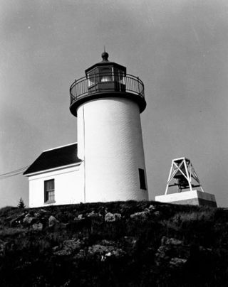
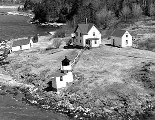
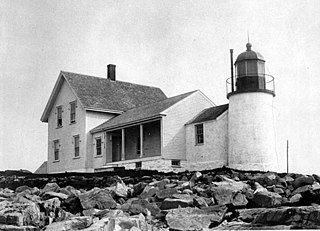
Baker Island Light is a lighthouse on Baker Island, Maine, which is part of Acadia National Park. The light station was established in 1828 as a guide to the southern entrance to Frenchman Bay. The present tower was built in 1855; the well-preserved tower, keeper's house, and associated outbuildings were listed on the National Register of Historic Places in 1988.

The Sheepscot Historic District encompasses a historic village in Alna and Newcastle, Maine. Located just below the mouth of Dyer Brook where it enters the Sheepscot River, the 1,200-acre (490 ha) includes an area that has seen little alteration in more than 100 years, and includes one of the oldest roadways in the state. The area is archaeologically sensitive for prehistoric and historic settlement sites. The district was added to the National Register of Historic Places on June 23, 1978.
Fisherman Island, or Fisherman's Island, is a 71-acre (29 ha) island, on the central coast of Maine, United States. Located roughly midway between Damariscove Island and the mainland at Ocean Point, the privately owned island has a history of human activity predating the colonial period, and was settled by English fishermen in the 17th century. The island was listed on the National Register of Historic Places in 2015 for the significance of its prehistoric archaeological sites.


