
West Quoddy Head, in Quoddy Head State Park, Lubec, Maine, is the easternmost point of the contiguous United States. In 1808 a lighthouse was constructed at the site to guide ships through the Quoddy Narrows. The current tower, with distinctive red-and-white stripes, was constructed in 1858 and is an active aid to navigation. The 3rd order Fresnel lens is the only 3rd order and one of only eight Fresnel lenses still in use on the Maine Coast.

Execution Rocks Light is a lighthouse in the middle of Long Island Sound on the border between New Rochelle and Sands Point, New York. It stands 55 feet (17 m) tall, with a white light flashing every 10 seconds. The granite tower is painted white with a brown band around the middle. It has an attached stone keeper's house which has not been inhabited since the light was automated in 1979.

Butler Flats Light is a sparkplug lighthouse located in the outer harbor of New Bedford, Massachusetts, at the mouth of the Acushnet River. Built in 1898 by the United States Lighthouse Board, it is the only known caisson lighthouse designed by a marine architect. The light was added to the National Register of Historic Places as Butler Flats Light Station on June 15, 1987. Automated in 1978, it is now operated by the city as a private aid to navigation.

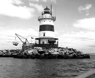
Orient Point Light is a sparkplug lighthouse off Orient Point, New York in Plum Gut of Long Island Sound – the deep and narrow gap between Orient Point and Plum Island. It was built in 1899 and was automated in 1954. The lighthouse was listed on the National Register of Historic Places in 2007.

The Robbins Reef Light Station is a sparkplug lighthouse located off Constable Hook in Bayonne, Hudson County, New Jersey, United States, along the west side of Main Channel, Upper New York Bay. The tower and integral keepers quarters were built in 1883. It replaced an octagonal granite tower built in 1839. The U.S. Coast Guard owned and operated the light station until the 2000s.

Greens Ledge Lighthouse is a historic offshore lighthouse in the western Long Island Sound near Norwalk, Connecticut and Darien, Connecticut. It is one of 33 sparkplug lighthouses still in existence in the United States and remains an active aid to navigation. It sits in ten feet of water on the west end of Greens Ledge, a shallow underwater reef that runs a mile west of Sheffield Island and is roughly a mile south of the entrance to Five Mile River at Rowayton. Completed in 1902 by the Philadelphia Construction Company, the cast-iron structure is approximately 90 feet tall including roughly 15 feet of the submerged caisson. In 1933, more than 30,000 tons of rocks from the excavation of Radio City Music Hall were added to the riprap foundation. The light was added to the National Register of Historic Places as Greens Ledge Lighthouse on May 29, 1990.
Peck Ledge Light, also known as "Peck Ledge Lighthouse", is a sparkplug lighthouse in Norwalk, Connecticut, United States, southeast of Norwalk Harbor and northeast of Goose Island among the Norwalk Islands on Long Island Sound. The lighthouse is about two miles (3 km) from Calf Pasture Beach in Norwalk and can be seen from the beach.

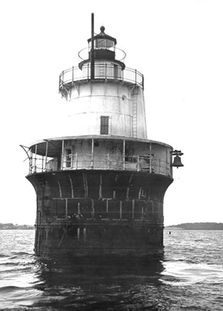
Southwest Ledge Light is an active lighthouse marking the main entrance channel to the harbor of New Haven, Connecticut. Completed in 1877, it was one of the first to be built on a cylindrical iron foundation, an innovation by Maj. George H. Elliot to address shifting ice that is regarded to be very important in lighthouse design. The lighthouse was listed on the National Register of Historic Places in 1990 as Southwest Ledge Lighthouse.

Rockland Harbor Breakwater Light is a historic lighthouse complex at the end of the Rockland Breakwater in the harbor of Rockland, Maine. Replacing a light station at Jameson Point, the light was established in 1902, about two years after completion of the breakwater. Now automated, it continues to serve as an active aid to navigation. The light was added to the National Register of Historic Places as Rockland Breakwater Lighthouse on March 20, 1981.

The Sharps Island Light is the third lighthouse to stand nearly 3 miles (5 km) south-southwest from the southern end of Tilghman Island in Maryland's Chesapeake Bay. The structure is best known today for evoking the Leaning Tower of Pisa, a condition caused by an ice floe in 1977.

The Fort Point Light, or Fort Point Light Station, is located in Fort Point State Park, in Stockton Springs, Maine. A lighthouse at this point has served as an active aid to navigation since 1835; the present lighthouse dates to 1857, and is listed on the National Register of Historic Places.

Borden Flats Light is a historic lighthouse on the Taunton River in Fall River, Massachusetts, US. It is a tower-on-caisson type known as a sparkplug lighthouse.
Latimer Reef Light is a sparkplug lighthouse on Latimer's Reef in Fishers Island Sound. The lighthouse is located one mile northwest of East Point on Fisher's Island, Suffolk County, New York. Originally called Latemore's Reef after James Latemore.
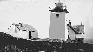
Browns Head Light is a lighthouse in Vinalhaven, Maine. Established in 1832, it is an active aid to navigation, marking the southern side of the western entrance to the Fox Island Thoroughfare, a busy strait separating Vinalhaven Island from North Haven. The present lighthouse was built in 1857; and was listed on the National Register of Historic Places as "Browns Head Light Station" on January 27, 1983.

Egg Rock Light is a lighthouse on Frenchman Bay, Maine. Built in 1875, it is one of coastal Maine's architecturally unique lighthouses, with a square tower projecting through the square keeper's house. Located on Egg Rock, midway between Mount Desert Island and the Schoodic Peninsula, it is an active aid to navigation, flashing red every 40 seconds. The light was listed on the National Register of Historic Places as Egg Rock Light Station in 1988.

Heron Neck Light is a lighthouse on Green's Island in Vinalhaven, Maine at the south end of Penobscot Bay. It was established in 1854 as an aid to navigation for Vinalhaven's main port, and for the Hurricane Channel extending northwest from Heron's Neck. The light was automated in 1984. It was listed on the National Register of Historic Places as Heron Neck Light Station on January 21, 1988.
Indian Island Light is a lighthouse on Indian Island on the eastern side of the entrance to Rockport Harbor, Maine. It was first established in 1850. The present structure was built in 1875. It was deactivated in 1934 and is now a private residence. It was listed on the National Register of Historic Places as Indian Island Light Station on March 23, 1988.
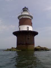
Lubec Channel Light is a sparkplug lighthouse in Lubec, Maine. Established in 1890, it is one of three surviving sparkplug lights in the state, and served as an important aid to navigation on the route from the Bay of Fundy to Eastport, Maine and the St. Croix River It is set in shallow waters in the Lubec Channel, about 500 feet (150 m) from the Canada–United States border. The lighthouse was listed on the National Register of Historic Places as Lubec Channel Light Station on March 14, 1988. The lighthouse was sold by auction into private hands on 2007.

Pumpkin Island Light is a lighthouse on Pumpkin Island, at the northwestern entrance to Eggemoggin Reach, a channel running northwest to southeast between Penobscot Bay and Blue Hill Bay on the central-eastern coast of Maine. The light station was established in 1854 and discontinued in 1933. It was listed on the National Register of Historic Places as Pumpkin Island Light Station on February 1, 1988. The island and former light station are privately owned.

Saddleback Ledge Light is a lighthouse on Saddleback Ledge, an islet lying between Isle au Haut and Vinalhaven, Maine, in the middle of the southeastern entrance to Penobscot Bay. The station was established and the current structure, designed by Alexander Parris, was built in 1839. One of Maine's oldest lighthouses, it was listed on the National Register of Historic Places as Saddleback Ledge Light Station on March 14, 1988.


