
Vinalhaven is a town on the larger of the two Fox Islands in Knox County, Maine, United States. Vinalhaven is also used to refer to the island itself. The population was 1,279 at the 2020 census. It is home to a thriving lobster fishery and hosts a summer colony. Since there is no bridge to the island, Vinalhaven is primarily accessible from Rockland via an approximately 75-minute state ferry ride across West Penobscot Bay, or by air taxi from Knox County Regional Airport.

Goat Island Light is a lighthouse located off Cape Porpoise near Kennebunkport in southern Maine. Goat Island Light was established in 1835 to guard the entrance to Cape Porpoise Harbor. The original station was upgraded in 1859 to the current brick tower with a fifth order Fresnel lens. Keeper's quarters were added to the island in 1860. The light station was automated by the United States Coast Guard in 1990 and is currently active. The keepers dwellings and tower are leased to the Kennebunkport Conservation Trust. Goat Island Light can be seen from shore in Cape Porpoise Harbor just off State Route 9 north of Kennebunkport or is viewable by boat. The island is currently closed to the public except by special arrangement.

Rockland Harbor Breakwater Light is a historic lighthouse complex at the end of the Rockland Breakwater in the harbor of Rockland, Maine. Replacing a light station at Jameson Point, the light was established in 1902, about two years after completion of the breakwater. Now automated, it continues to serve as an active aid to navigation. The light was added to the National Register of Historic Places as Rockland Breakwater Lighthouse on March 20, 1981.

Goose Rocks Light is a sparkplug lighthouse located near North Haven, Maine in Penobscot Bay. It stands at the eastern entrance to the Fox Islands Thoroughfare, a busy mile-wide passage separating North Haven from Vinalhaven. Built in 1890, it was added to the National Register of Historic Places as Goose Rocks Light Station on January 21, 1988. The structure is now privately owned by a preservation group, and remains an active aid to navigation.

The Fort Point Light, or Fort Point Light Station, is located in Fort Point State Park, in Stockton Springs, Maine. A lighthouse at this point has served as an active aid to navigation since 1835; the present lighthouse dates to 1857, and is listed on the National Register of Historic Places.

The Tarpaulin Cove Light is a historic lighthouse on Naushon Island, one of the Elizabeth Islands of southern Massachusetts. It is located in the town of Gosnold, Massachusetts. Built on the site of a light station first established privately in the 18th century, the current tower dates from 1891. A keeper's house built at the same time has not survived. The light is 78 feet (24 m) above Mean High Water, and its white light is visible for 9 nautical miles.

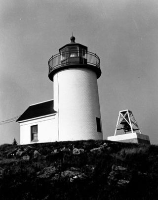
Marshall Point Light Station is a lighthouse at the entrance of Port Clyde Harbor in Port Clyde, Maine. The light station was established in 1832.

The Burnt Island Light, built in 1821, is the second oldest surviving lighthouse in Maine. It hosts a living history museum run by the state Department of Marine Resources. It was added to the National Register of Historic Places as Burnt Island Light Station on November 23, 1977.
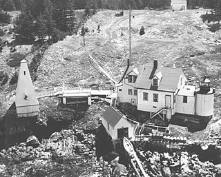
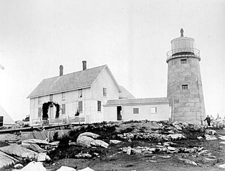
Browns Head Light is a lighthouse in Vinalhaven, Maine. Established in 1832, it is an active aid to navigation, marking the southern side of the western entrance to the Fox Island Thoroughfare, a busy strait separating Vinalhaven Island from North Haven. The present lighthouse was built in 1857; and was listed on the National Register of Historic Places as "Browns Head Light Station" on January 27, 1983.

The Burnt Coat Harbor Light Station is a lighthouse on Swan's Island, Maine. It is located on Hockamock Head, at the entrance to Burnt Coat Harbor and at the end of Harbor Road. Hockamock Head is a peninsula extending south from the center of the island, dividing the island's main harbor from Toothacker Bay. The light marks the entrance to Burnt Coat Harbor. It was built in 1872, and is a well-preserved 19th-century light station. It was listed on the National Register of Historic Places in 1988.
Curtis Island Light, originally Negro Island Light, is a lighthouse marking the approach to the harbor of Camden, Maine. It is located on Curtis Island, which shelters the harbor from ocean storms. It was first established in 1835, and the present structure was built in 1896. The light was automated in 1972, and listed on the National Register of Historic Places in 1973.

Egg Rock Light is a lighthouse on Frenchman Bay, Maine. Built in 1875, it is one of coastal Maine's architecturally unique lighthouses, with a square tower projecting through the square keeper's house. Located on Egg Rock, midway between Mount Desert Island and the Schoodic Peninsula, it is an active aid to navigation, flashing red every 40 seconds. The light was listed on the National Register of Historic Places as Egg Rock Light Station in 1988.

Great Duck Island Light is a lighthouse on Great Duck Island in the town of Frenchboro, Maine, USA. Established in 1890, the light marks the approach to Blue Hill Bay and the southern approaches to Mount Desert Island on the central coast of Maine. The light was listed on the National Register of Historic Places as Great Duck Island Light Station on March 14, 1988. The light is an active aid to navigation maintained by the United States Coast Guard; the property is owned by the College of the Atlantic, which operates a research station there.

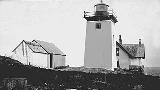
Grindel Point Light is a lighthouse in Islesboro, Maine, marking the west entrance to Gilkey Harbor at the westernmost point of the eponymous island. The light station was established in 1850, and the present tower and keeper's house were built in 1874. The station was deactivated in 1934 and reactivated in 1987. It was listed on the National Register of Historic Places in 1987. The keeper's house now houses the Grindel Point Sailor's Museum and the lighthouse tower is open for tours in the summer.
Indian Island Light is a lighthouse on Indian Island on the eastern side of the entrance to Rockport Harbor, Maine. It was first established in 1850. The present structure was built in 1875. It was deactivated in 1934 and is now a private residence. It was listed on the National Register of Historic Places as Indian Island Light Station on March 23, 1988.
Monhegan Island Light is a lighthouse on Monhegan Island, Maine. It was first established in 1824. The present structure was built in 1850. It was Alexander Parris's last significant design. It is the second highest light in Maine — Seguin Light, with a 6-foot taller tower, is 2 feet higher in elevation. It was listed on the National Register of Historic Places as Monhegan Island Lighthouse and Quarters on May 7, 1980, reference number 80000239.

Pumpkin Island Light is a lighthouse on Pumpkin Island, at the northwestern entrance to Eggemoggin Reach, a channel running northwest to southeast between Penobscot Bay and Blue Hill Bay on the central-eastern coast of Maine. The light station was established in 1854 and discontinued in 1933. It was listed on the National Register of Historic Places as Pumpkin Island Light Station on February 1, 1988. The island and former light station are privately owned.

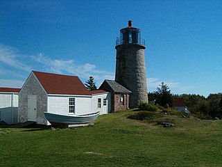
Saddleback Ledge Light is a lighthouse on Saddleback Ledge, an islet lying between Isle au Haut and Vinalhaven, Maine, in the middle of the southeastern entrance to Penobscot Bay. The station was established and the current structure, designed by Alexander Parris, was built in 1839. One of Maine's oldest lighthouses, it was listed on the National Register of Historic Places as Saddleback Ledge Light Station on March 14, 1988.

Tenants Harbor Light, also known as Southern Island Light, is a lighthouse at the mouth of Tenants Harbor, St. George, Maine, United States. It appears in paintings by Andrew Wyeth and his son Jamie Wyeth, who have owned the lighthouse since 1978.
Whitehead Light is a lighthouse on Whitehead Island, on Muscle Ridge Channel, in the southwestern entrance to Penobscot Bay, Maine. It is in the town of St.George. Established in 1804, it is one of Maine's oldest light stations, with its present tower built in 1852 to a design attributed to Alexander Parris. It was listed on the National Register of Historic Places as Whitehead Light Station on March 14, 1988. The property is now owned by not for profit Pine Island Camp. Whitehead light station offers to the public various stays at the light station from getaway weekends to learning retreats and renting the station as a vacation home. The light itself remains an active aid to navigation, maintained by the United States Coast Guard.


