
Nobska Light, originally called Nobsque Light, also known as Nobska Point Light is a lighthouse located near the division between Buzzards Bay, Nantucket Sound, and Vineyard Sound in the settlement of Woods Hole, Massachusetts on the southwestern tip of Cape Cod, Massachusetts. It overlooks Martha's Vineyard and Nonamesset Island. The light station was established in 1828, with the tower protruding above the keeper's house, and was replaced in 1876 by the current 42 foot tall iron tower. The light station was added to the National Register of Historic Places as Nobska Point Light Station in 1987.

Goat Island Light is a lighthouse located off Cape Porpoise near Kennebunkport in southern Maine. Goat Island Light was established in 1835 to guard the entrance to Cape Porpoise Harbor. The original station was upgraded in 1859 to the current brick tower with a fifth order Fresnel lens. Keeper's quarters were added to the island in 1860. The light station was automated by the United States Coast Guard in 1990 and is currently active. The keepers dwellings and tower are leased to the Kennebunkport Conservation Trust. Goat Island Light can be seen from shore in Cape Porpoise Harbor just off State Route 9 north of Kennebunkport or is viewable by boat. The island is currently closed to the public except by special arrangement.

Rockland Harbor Breakwater Light is a historic lighthouse complex at the end of the Rockland Breakwater in the harbor of Rockland, Maine. Replacing a light station at Jameson Point, the light was established in 1902, about two years after completion of the breakwater. Now automated, it continues to serve as an active aid to navigation. The light was added to the National Register of Historic Places as Rockland Breakwater Lighthouse on March 20, 1981.

The Fort Point Light, or Fort Point Light Station, is located in Fort Point State Park, in Stockton Springs, Maine. A lighthouse at this point has served as an active aid to navigation since 1835; the present lighthouse dates to 1857, and is listed on the National Register of Historic Places.

Annisquam Harbor Light Station is a historic lighthouse on Wigwam Point in the Annisquam neighborhood of Gloucester, Massachusetts. It can be viewed from nearby Wingaersheek Beach, Gloucester. It lies on the Annisquam River and is one of the four oldest lighthouses to surround the Gloucester peninsula as well as; Eastern Point Light, Ten Pound Island Light, and Thacher Island Light.

The Doubling Point Range Lights are a pair of range lights on the Kennebec River, in Arrowsic, Maine. Built in 1898 as part of a major improvement on navigational aids on the river, they are the only surviving pair of range lights in the state. They were listed on the National Register of Historic Places as Kennebec River Light Station on January 21, 1988.

Doubling Point Light is a lighthouse on the Kennebec River in Arrowsic, Maine. It was established in 1898, fifteen years after the founding of the Bath Iron Works, a major shipbuilder, 1.5 miles (2.4 km) upriver. It was part of a major upgrade of the river's lights — the Doubling Point Light and the separate Range Lights on the point, Perkins Island Light, and Squirrel Point Light were all built at the same time. The light was listed on the National Register of Historic Places as Doubling Point Light Station on January 21, 1988. It remains an active aid to navigation.

Bear Island Light is a lighthouse on Bear Island near Mt. Desert Island, at the entrance to Northeast Harbor, Maine. It was first established in 1839. The present structure was built in 1889. It was deactivated in 1981 and relit as a private aid to navigation by the Friends of Acadia National Park in 1989. Bear Island Light was listed on the National Register of Historic Places as Bear Island Light Station on March 14, 1988.

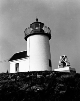
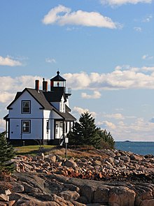
The Burnt Coat Harbor Light Station is a lighthouse on Swan's Island, Maine. It is located on Hockamock Head, at the entrance to Burnt Coat Harbor and at the end of Harbor Road. Hockamock Head is a peninsula extending south from the center of the island, dividing the island's main harbor from Toothacker Bay. The light marks the entrance to Burnt Coat Harbor. It was built in 1872, and is a well-preserved 19th-century light station. It was listed on the National Register of Historic Places in 1988.
Curtis Island Light, originally Negro Island Light, is a lighthouse marking the approach to the harbor of Camden, Maine. It is located on Curtis Island, which shelters the harbor from ocean storms. It was first established in 1835, and the present structure was built in 1896. The light was automated in 1972, and listed on the National Register of Historic Places in 1973.

Grindel Point Light is a lighthouse in Islesboro, Maine, marking the west entrance to Gilkey Harbor at the westernmost point of the eponymous island. The light station was established in 1850, and the present tower and keeper's house were built in 1874. The station was deactivated in 1934 and reactivated in 1987. It was listed on the National Register of Historic Places in 1987. The keeper's house now houses the Grindel Point Sailor's Museum and the lighthouse tower is open for tours in the summer.

Hendricks Head Light is a lighthouse in Southport, Maine marking the west side of the mouth of the Sheepscot River. The light station was established in 1829, and its present structures date to 1875. It was deactivated in 1933, but relit in 1951. The two-story wood keeper's house is now a private summer residence. The light is on continuously, showing white to the west and red to the east. It was listed on the National Register of Historic Places as Hendricks Head Light Station on November 20, 1987.

Heron Neck Light is a lighthouse on Green's Island in Vinalhaven, Maine at the south end of Penobscot Bay. It was established in 1854 as an aid to navigation for Vinalhaven's main port, and for the Hurricane Channel extending northwest from Heron's Neck. The light was automated in 1984. It was listed on the National Register of Historic Places as Heron Neck Light Station on January 21, 1988.
Indian Island Light is a lighthouse on Indian Island on the eastern side of the entrance to Rockport Harbor, Maine. It was first established in 1850. The present structure was built in 1875. It was deactivated in 1934 and is now a private residence. It was listed on the National Register of Historic Places as Indian Island Light Station on March 23, 1988.
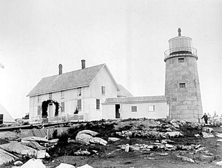
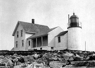
Monhegan Island Light is a lighthouse on Monhegan Island, Maine. It was first established in 1824. The present structure was built in 1850. It was Alexander Parris's last significant design. It is the second highest light in Maine — Seguin Light, with a 6-foot taller tower, is 2 feet higher in elevation. It was listed on the National Register of Historic Places as Monhegan Island Lighthouse and Quarters on May 7, 1980, reference number 80000239.

Perkins Island Light is a lighthouse on the Kennebec River in Maine. It was established in 1898, as part of a major upgrade of the river's lights — the Doubling Point Light and the separate Range Lights on the point, Perkins Island Light, and Squirrel Point Light were all built at the same time. It was listed on the National Register of Historic Places as Perkins Island Light Station in 1988.

Ram Island Light is a lighthouse located just offshore of Ram Island, marking the eastern entrance to Boothbay Harbor, Maine, and the west side of the mouth of the Damariscotta River. It was built in 1883 and automated in 1965. It was listed on the National Register of Historic Places as Ram Island Light Station on January 21, 1988.
Whitehead Light is a lighthouse on Whitehead Island, on Muscle Ridge Channel, in the southwestern entrance to Penobscot Bay, Maine. It is in the town of St.George. Established in 1804, it is one of Maine's oldest light stations, with its present tower built in 1852 to a design attributed to Alexander Parris. It was listed on the National Register of Historic Places as Whitehead Light Station on March 14, 1988. The property is now owned by not for profit Pine Island Camp. Whitehead light station offers to the public various stays at the light station from getaway weekends to learning retreats and renting the station as a vacation home. The light itself remains an active aid to navigation, maintained by the United States Coast Guard.
Winter Harbor Light is a lighthouse in Winter Harbor, Maine. It is located on Mark Island, a small island between the Schoodic Peninsula and Turtle Island, near the entry to the town's main harbor. The light was built in 1856 and was deactivated in 1933; it is no longer an aid to navigation, and is privately owned. The light was listed on the National Register of Historic Places as Winter Harbor Light Station on February 1, 1988.

Baker Island Light is a lighthouse on Baker Island, Maine, which is part of Acadia National Park. The light station was established in 1828 as a guide to the southern entrance to Frenchman Bay. The present tower was built in 1855; the well-preserved tower, keeper's house, and associated outbuildings were listed on the National Register of Historic Places in 1988.
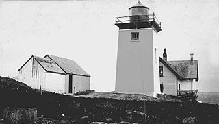
 USCG photo of 1850 structure


