Goat Island Light

Last updated

Goat Island Light
Goat-island-light.jpg
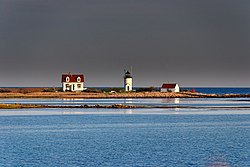
Goat Island Light from Cape Porpoise
Goat Island Light
LocationGoat Island, Cape Porpoise harbor
Coordinates 43°21′28″N70°25′30″W / 43.35778°N 70.42500°W / 43.35778; -70.42500
Tower
Constructed1835
FoundationNatural, emplaced
ConstructionBrick
Automated1990
Height7.5 m (25 ft)  OOjs UI icon edit-ltr-progressive.svg
ShapeCylindrical
MarkingsWhite with black lantern
HeritageNational Register of Historic Places listed place  OOjs UI icon edit-ltr-progressive.svg
Fog signal HORN: 1 every 15s
Light
First lit1859 (current tower)
Focal height38 feet (12 m)
Lens5th order Fresnel lens (original), 12 inches (300 mm) (current)
Range12 nautical miles (22 km; 14 mi)
Characteristic Flashing white 6s.
Goat Island Light Station
Nearest city Cape Porpoise, Maine
Built1859
ArchitectUS Army Corps of Engineers
MPS Light Stations of Maine MPS
NRHP reference No. 87002268 [1]
Added to NRHPMarch 23, 1988

Goat Island Light is a lighthouse located off Cape Porpoise near Kennebunkport in southern Maine. [2] [3] [4] Goat Island Light was established in 1835 to guard the entrance to Cape Porpoise Harbor. The original station was upgraded in 1859 to the current brick tower with a fifth order Fresnel lens. Keeper's quarters were added to the island in 1860. The light station was automated by the United States Coast Guard in 1990 and is currently active. The keepers dwellings and tower are leased to the Kennebunkport Conservation Trust. [4] Goat Island Light can be seen from shore in Cape Porpoise Harbor just off State Route 9 north of Kennebunkport or is viewable by boat. The island is currently closed to the public except by special arrangement.

Contents

Description and history

The coast of southern Maine east of the Kennebunk River is studded with a group of small islands and rock ledges near the headland called Cape Porpoise. Goat Island is a treeless outer island, about 7.7 acres (3.1 ha) in size. The lighthouse is set on the island's southern shore, with the keeper's house a short way to its north. A boathouse and dock stand and the western end of the island, with a small brick oil house between it and the tower. [5]

The present tower is a circular brick structure, with the lantern 25 feet (7.6 m) above ground level. The lantern house presently houses a fifth order Fresnel lens. A metal walkway and railing surround the lantern house, and there is a single window in the tower. A small workroom with two doors projects from the tower. The keeper's house is an L-shaped wood-frame structure, 1+12 stories in height, with clapboard siding replacing its original board-and-batten siding. The roof is pierced by dormers, also a later alteration. It was originally joined to the tower by a covered walkway. The boathouse is a simple rectangular single-story structure with a gable roof and clapboard siding. The oil house is a small brick structure with a gable roof that has a vent at one end. [5]

Goat Island Light was authorized in 1833 as an aid to navigation for reaching the harbor at Cape Porpoise. The first tower built was 20 feet (6.1 m) in height; the present tower and keeper's house were built in 1859. The boathouse was built in 1905. [5]

See also

Related Research Articles

<span class="mw-page-title-main">Cape Neddick Light</span> Lighthouse in Maine, US

The Cape Neddick Light is a lighthouse in Cape Neddick, York, Maine. In 1874 Congress appropriated $15,000 to build a light station at the "Nubble" and in 1879 construction began. Cape Neddick Light Station was dedicated by the U.S. Lighthouse Service and put into use in 1879. It is still in use today.

<span class="mw-page-title-main">Edgartown Harbor Light</span> Lighthouse in Massachusetts, United States

Edgartown Harbor Light is a lighthouse located in Edgartown, Massachusetts, United States, where it marks the entrance to Edgartown Harbor and Katama Bay. It is one of five lighthouses on the island of Martha's Vineyard. The first lighthouse, a two-story wooden structure that also served as the keeper's house, was constructed in 1828. It was demolished, and replaced by the current cast-iron tower, in 1939. Originally located on an artificial island 1/4 miles from shore, the lighthouse is now surrounded by a beach formed, since 1939, by sand accumulating around the stone causeway connecting it to the mainland.

<span class="mw-page-title-main">Fort Point Light (Maine)</span> Lighthouse in Maine, US

The Fort Point Light, or Fort Point Light Station, is located in Fort Point State Park, in Stockton Springs, Maine. A lighthouse at this point has served as an active aid to navigation since 1835; the present lighthouse dates to 1857, and is listed on the National Register of Historic Places.

<span class="mw-page-title-main">Annisquam Harbor Light</span> Lighthouse

Annisquam Harbor Light Station is a historic lighthouse on Wigwam Point in the Annisquam neighborhood of Gloucester, Massachusetts. It can be viewed from nearby Wingaersheek Beach, Gloucester. It lies on the Annisquam River and is one of the four oldest lighthouses to surround the Gloucester peninsula as well as; Eastern Point Light, Ten Pound Island Light, and Thacher Island Light.

<span class="mw-page-title-main">Whaleback Light</span> Lighthouse in Maine, US

Whaleback Light is a historic lighthouse marking the mouth of the Piscataqua River in Kittery, Maine. It is located on a rocky outcrop offshore southwest of Fort Foster and south of Wood Island in Kittery. The present tower was built in 1872. It was listed on the National Register of Historic Places in 1988.

<span class="mw-page-title-main">Bear Island Light</span> Lighthouse in Maine, United States

Bear Island Light is a lighthouse on Bear Island near Mt. Desert Island, at the entrance to Northeast Harbor, Maine. It was first established in 1839. The present structure was built in 1889. It was deactivated in 1981 and relit as a private aid to navigation by the Friends of Acadia National Park in 1989. Bear Island Light was listed on the National Register of Historic Places as Bear Island Light Station on March 14, 1988.

<span class="mw-page-title-main">Burnt Coat Harbor Light</span> Lighthouse in Maine, US

The Burnt Coat Harbor Light Station is a lighthouse on Swan's Island, Maine. It is located on Hockamock Head, at the entrance to Burnt Coat Harbor and at the end of Harbor Road. Hockamock Head is a peninsula extending south from the center of the island, dividing the island's main harbor from Toothacker Bay. The light marks the entrance to Burnt Coat Harbor. It was built in 1872, and is a well-preserved 19th-century light station. It was listed on the National Register of Historic Places in 1988.

<span class="mw-page-title-main">Egg Rock Light (Maine)</span> Lighthouse in Maine, US

Egg Rock Light is a lighthouse on Frenchman Bay, Maine. Built in 1875, it is one of coastal Maine's architecturally unique lighthouses, with a square tower projecting through the square keeper's house. Located on Egg Rock, midway between Mount Desert Island and the Schoodic Peninsula, it is an active aid to navigation, flashing red every 40 seconds. The light was listed on the National Register of Historic Places as Egg Rock Light Station in 1988.

<span class="mw-page-title-main">Great Duck Island Light</span> Lighthouse in Maine, US

Great Duck Island Light is a lighthouse on Great Duck Island in the town of Frenchboro, Maine, USA. Established in 1890, the light marks the approach to Blue Hill Bay and the southern approaches to Mount Desert Island on the central coast of Maine. The light was listed on the National Register of Historic Places as Great Duck Island Light Station on March 14, 1988. The light is an active aid to navigation maintained by the United States Coast Guard; the property is owned by the College of the Atlantic, which operates a research station there.

<span class="mw-page-title-main">Grindel Point Light</span> Lighthouse in Maine, US

Grindel Point Light is a lighthouse in Islesboro, Maine, marking the west entrance to Gilkey Harbor at the westernmost point of the eponymous island. The light station was established in 1850, and the present tower and keeper's house were built in 1874. The station was deactivated in 1934 and reactivated in 1987. It was listed on the National Register of Historic Places in 1987. The keeper's house now houses the Grindel Point Sailor's Museum and the lighthouse tower is open for tours in the summer.

<span class="mw-page-title-main">Heron Neck Light</span> Lighthouse in Maine, US

Heron Neck Light is a lighthouse on Green's Island in Vinalhaven, Maine at the south end of Penobscot Bay. It was established in 1854 as an aid to navigation for Vinalhaven's main port, and for the Hurricane Channel extending northwest from Heron's Neck. The light was automated in 1984. It was listed on the National Register of Historic Places as Heron Neck Light Station on January 21, 1988.

<span class="mw-page-title-main">Indian Island Light</span> Lighthouse in Maine, US

Indian Island Light is a lighthouse on Indian Island on the eastern side of the entrance to Rockport Harbor, Maine. It was first established in 1850. The present structure was built in 1875. It was deactivated in 1934 and is now a private residence. It was listed on the National Register of Historic Places as Indian Island Light Station on March 23, 1988.

<span class="mw-page-title-main">Little River Light</span> Lighthouse in Maine, US

Little River Light is a lighthouse on an island at the mouth of the Little River, in Cutler, Maine. A light station was first established at this site in 1846, and the present structure was built in 1876. It is one of the only iron lighthouses in the state, and was listed on the National Register of Historic Places as Little River Light Station on March 14, 1988. The light station is now owned by the American Lighthouse Foundation, which offers overnight stays in the keeper's house, and occasional tours of the property.

<span class="mw-page-title-main">Mount Desert Light</span> Lighthouse in Maine, US

Mount Desert Light is a lighthouse on Mount Desert Rock, a small island about 18 nautical miles south of Mount Desert Island, in the U.S. state of Maine. While the first light station was established in 1830, the current lighthouse was built in 1847. It was listed on the National Register of Historic Places as Mount Desert Light Station in 1988. It is currently owned and operated by the College of the Atlantic, located in Bar Harbor, Maine.

<span class="mw-page-title-main">Petit Manan Light</span> Lighthouse in Maine, US

Petit Manan Light is a lighthouse on Petit Manan Island, Maine. The island is at the end of a series of ledges extending out from Petit Manan Point, between Dyer Bay and Pigeon Hill Bay, that projects into the Gulf of Maine.

<span class="mw-page-title-main">Prospect Harbor Point Light</span> Lighthouse in Maine, US

Prospect Harbor Point Light is a lighthouse on Prospect Harbor Point, which divides Sand Cove from Inner Harbor at the head of Prospect Harbor on the southern shore of Gouldsboro, Maine. Also known as Prospect Harbor Light, it was first established in 1850. The present structure was built in 1891. It was listed on the National Register of Historic Places as Prospect Harbor Light Station in 1988.

<span class="mw-page-title-main">Pumpkin Island Light</span> Lighthouse in Maine, US

Pumpkin Island Light is a lighthouse on Pumpkin Island, at the northwestern entrance to Eggemoggin Reach, a channel running northwest to southeast between Penobscot Bay and Blue Hill Bay on the central-eastern coast of Maine. The light station was established in 1854 and discontinued in 1933. It was listed on the National Register of Historic Places as Pumpkin Island Light Station on February 1, 1988. The island and former light station are privately owned.

<span class="mw-page-title-main">Winter Harbor Light</span> Lighthouse in Maine, US

Winter Harbor Light is a lighthouse in Winter Harbor, Maine. It is located on Mark Island, a small island between the Schoodic Peninsula and Turtle Island, near the entry to the town's main harbor. The light was built in 1856 and was deactivated in 1933; it is no longer an aid to navigation, and is privately owned. The light was listed on the National Register of Historic Places as Winter Harbor Light Station on February 1, 1988.

<span class="mw-page-title-main">Baker Island Light</span> Lighthouse in Maine, US

Baker Island Light is a lighthouse on Baker Island, Maine, which is part of Acadia National Park. The light station was established in 1828 as a guide to the southern entrance to Frenchman Bay. The present tower was built in 1855; the well-preserved tower, keeper's house, and associated outbuildings were listed on the National Register of Historic Places in 1988.

<span class="mw-page-title-main">Rawley Point Light</span> Lighthouse

Rawley Point Light is a lighthouse located in Point Beach State Forest, near Two Rivers, Wisconsin. At 111 feet (34 m) tall, it is the tallest lighthouse on the Wisconsin Shore and it is listed on the National Register of Historic Places.

References

  1. "National Register Information System". National Register of Historic Places . National Park Service. March 13, 2009.
  2. United States Coast Guard (2009). Light List, Volume I, Atlantic Coast, St. Croix River, Maine to Shrewsbury River, New Jersey. p. 67.
  3. Rowlett, Russ (October 9, 2009). "Lighthouses of the United States: Southern Maine". The Lighthouse Directory. University of North Carolina at Chapel Hill.
  4. 1 2 "Historic Light Station Information and Photography: Maine". United States Coast Guard Historian's Office. August 8, 2009. Archived from the original on May 1, 2017.
  5. 1 2 3 "NRHP nomination for Goat Island Light Station". National Park Service. Retrieved June 20, 2015.