
Portland Head Light is a historic lighthouse in Cape Elizabeth, Maine. The light station sits on a headland at the entrance of the primary shipping channel into Portland Harbor, which is within Casco Bay in the Gulf of Maine. Completed in 1791, it is the oldest lighthouse in Maine. The light station is automated, and the tower, beacon, and foghorn are maintained by the United States Coast Guard, while the former lighthouse keeper's house is a maritime museum within Fort Williams Park.

West Quoddy Head, in Quoddy Head State Park, Lubec, Maine, is the easternmost point of the contiguous United States. In 1808 a lighthouse was constructed at the site to guide ships through the Quoddy Narrows. The current tower, with distinctive red-and-white stripes, was constructed in 1858 and is an active aid to navigation. The 3rd order Fresnel lens is the only 3rd order and one of only eight Fresnel lenses still in use on the Maine Coast.

Chatham Lighthouse, known as Twin Lights prior to 1923, is a lighthouse in Chatham, Massachusetts, near the "elbow" of Cape Cod. The original station, close to the shore, was built in 1808 with two wooden towers, which were both replaced in 1841. In 1877, two new towers, made of cast iron rings, replaced those. One of the towers was moved to the Eastham area, where it became known as Nauset Light in 1923.
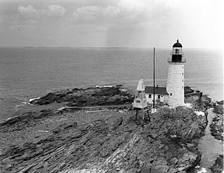
Halfway Rock Lighthouse is a lighthouse located on a barren ledge in Casco Bay, Maine. The lighthouse tower, which has a height of 76 feet (23 m), and the attached ex-boathouse are all that remains, as the other buildings have been taken away in storms. The name "Halfway Rock" comes from the position of the rock which is halfway between Cape Elizabeth and Cape Small, the southwest and northeast extremities of Casco Bay, which are about 18 nautical miles (33 km) apart.

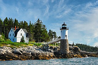
Goat Island Light is a lighthouse located off Cape Porpoise near Kennebunkport in southern Maine. Goat Island Light was established in 1835 to guard the entrance to Cape Porpoise Harbor. The original station was upgraded in 1859 to the current brick tower with a fifth order Fresnel lens. Keeper's quarters were added to the island in 1860. The light station was automated by the United States Coast Guard in 1990 and is currently active. The keepers dwellings and tower are leased to the Kennebunkport Conservation Trust. Goat Island Light can be seen from shore in Cape Porpoise Harbor just off State Route 9 north of Kennebunkport or is viewable by boat. The island is currently closed to the public except by special arrangement.

Marblehead Light is situated on Marblehead Neck in Essex County, Massachusetts. The current tower is a skeletal structure that replaced the original 1835 brick and wood tower in 1895. It is the only tower of its type in New England; the next similar tower is to be found at Coney Island, New York. It was listed in the National Register of Historic Places, on June 15, 1987 as number #87001479 under Lighthouses of Massachusetts Thematic Group.

The Fort Point Light, or Fort Point Light Station, is located in Fort Point State Park, in Stockton Springs, Maine. A lighthouse at this point has served as an active aid to navigation since 1835; the present lighthouse dates to 1857, and is listed on the National Register of Historic Places.

Hospital Point Range Front Light is a historic lighthouse at the end of Bayview Avenue in Beverly, Massachusetts. It forms the front half of a range which guides vessels toward Salem Harbor. The tower was added to the National Register of Historic Places as Hospital Point Light Station on September 28, 1987.

The Owls Head Light is an active aid to navigation located at the entrance of Rockland Harbor on western Penobscot Bay in the town of Owls Head, Knox County, Maine. The lighthouse is owned by the U.S. Coast Guard and licensed to the American Lighthouse Foundation. It is the centerpiece of 13-acre (5.3 ha) Owls Head State Park and was added to the National Register of Historic Places as Owls Head Light Station in 1978.
Isle au Haut Light, also called Robinson Point Light, is a lighthouse located at Robinson Point in Isle au Haut, Maine. The lighthouse was established in 1907.

Marshall Point Light Station is a lighthouse at the entrance of Port Clyde Harbor in Port Clyde, Maine. The light station was established in 1832.

The Burnt Island Light, built in 1821, is the second oldest surviving lighthouse in Maine. It hosts a living history museum run by the state Department of Marine Resources. It was added to the National Register of Historic Places as Burnt Island Light Station on November 23, 1977.

Doubling Point Light is a lighthouse on the Kennebec River in Arrowsic, Maine. It was established in 1898, fifteen years after the founding of the Bath Iron Works, a major shipbuilder, 1.5 miles (2.4 km) upriver. It was part of a major upgrade of the river's lights — the Doubling Point Light and the separate Range Lights on the point, Perkins Island Light, and Squirrel Point Light were all built at the same time. The light was listed on the National Register of Historic Places as Doubling Point Light Station on January 21, 1988. It remains an active aid to navigation.

Bear Island Light is a lighthouse on Bear Island near Mt. Desert Island, at the entrance to Northeast Harbor, Maine. It was first established in 1839. The present structure was built in 1889. It was deactivated in 1981 and relit as a private aid to navigation by the Friends of Acadia National Park in 1989. Bear Island Light was listed on the National Register of Historic Places as Bear Island Light Station on March 14, 1988.

Egg Rock Light is a lighthouse on Frenchman Bay, Maine. Built in 1875, it is one of coastal Maine's architecturally unique lighthouses, with a square tower projecting through the square keeper's house. Located on Egg Rock, midway between Mount Desert Island and the Schoodic Peninsula, it is an active aid to navigation, flashing red every 40 seconds. The light was listed on the National Register of Historic Places as Egg Rock Light Station in 1988.

Heron Neck Light is a lighthouse on Green's Island in Vinalhaven, Maine at the south end of Penobscot Bay. It was established in 1854 as an aid to navigation for Vinalhaven's main port, and for the Hurricane Channel extending northwest from Heron's Neck. The light was automated in 1984. It was listed on the National Register of Historic Places as Heron Neck Light Station on January 21, 1988.

Little River Light is a lighthouse on an island at the mouth of the Little River, in Cutler, Maine. A light station was first established at this site in 1846, and the present structure was built in 1876. It is one of the only iron lighthouses in the state, and was listed on the National Register of Historic Places as Little River Light Station on March 14, 1988. The light station is now owned by the American Lighthouse Foundation, which offers overnight stays in the keeper's house, and occasional tours of the property.

Petit Manan Light is a lighthouse on Petit Manan Island, Maine. The island is at the end of a series of ledges extending out from Petit Manan Point, between Dyer Bay and Pigeon Hill Bay, that projects into the Gulf of Maine.

Prospect Harbor Point Light is a lighthouse on Prospect Harbor Point, which divides Sand Cove from Inner Harbor at the head of Prospect Harbor on the southern shore of Gouldsboro, Maine. Also known as Prospect Harbor Light, it was first established in 1850. The present structure was built in 1891. It was listed on the National Register of Historic Places as Prospect Harbor Light Station in 1988.

Baker Island Light is a lighthouse on Baker Island, Maine, which is part of Acadia National Park. The light station was established in 1828 as a guide to the southern entrance to Frenchman Bay. The present tower was built in 1855; the well-preserved tower, keeper's house, and associated outbuildings were listed on the National Register of Historic Places in 1988.
 1916 postcard


