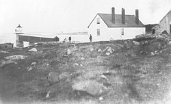
 Marshall Point Light before 1895 with original keeper's house
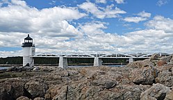 The light and access bridge
 View from the access bridge
 | |
 | |
| Location | Port Clyde, Maine |
|---|---|
| Coordinates | 43°55′2.718″N69°15′40.568″W / 43.91742167°N 69.26126889°W |
| Tower | |
| Constructed | 1832 |
| Foundation | Granite blocks |
| Construction | Granite and brick |
| Automated | 1971 |
| Height | 9 m (30 ft) |
| Shape | Cylindrical |
| Markings | White with black lantern |
| Heritage | National Register of Historic Places listed place |
| Fog signal | 1898: Bell 1969: Horn, 1 every 10s |
| Light | |
| First lit | 1858 |
| Focal height | 30 feet (9.1 m) |
| Lens | 5th order Fresnel lens (original), 12 inches (300 mm) (current) |
| Range | 13 nautical miles (24 km; 15 mi) |
| Characteristic | fixed white |
Marshall Point Light Station | |
| Nearest city | Port Clyde, Maine |
| Area | 5 acres (2.0 ha) |
| Built | 1857 |
| Architect | US Army Corps of Engineers |
| MPS | Light Stations of Maine MPS |
| NRHP reference No. | 87002262 [1] |
| Added to NRHP | March 23, 1988 |
Marshall Point Light Station is a lighthouse at the entrance of Port Clyde Harbor in Port Clyde, Maine. The light station was established in 1832. [2] [3]


