Fort Point Light (Maine)

Last updated
Fort Point Light
Fort point light station.jpg
Fort Point Light in September, 2005.
Fort Point Light (Maine)
Location Penobscot River Entrance
Coordinates 44°28′1.682″N68°48′42.058″W / 44.46713389°N 68.81168278°W / 44.46713389; -68.81168278
Tower
Constructed1836
Automated1988
Height9.5 m (31 ft)  OOjs UI icon edit-ltr-progressive.svg
ShapeSquare Brick Tower
MarkingsWhite
HeritageNational Register of Historic Places listed place  OOjs UI icon edit-ltr-progressive.svg
Fog signal HORN: 1 every 10s
Light
First lit1857 (current structure)
Focal height88 feet (27 m)
Lens4th order Fresnel Lens
Range15 nautical miles (28 km; 17 mi)
Characteristic F W
Fort Point Light Station
Nearest city Stockton Springs, Maine
Built1857
Architect US Army Corps of Engineers
MPS Light Stations of Maine MPS
NRHP reference No. 87002269 [1]
Added to NRHPMarch 23, 1988

The Fort Point Light, or Fort Point Light Station, is located in Fort Point State Park, in Stockton Springs, Maine. [2] [3] A lighthouse at this point has served as an active aid to navigation since 1835; the present lighthouse dates to 1857, and is listed on the National Register of Historic Places. [1]

Contents

Setting

Fort Point State Park is located at the easternmost tip of Cape Jellison, a triangular peninsula which juts into Penobscot Bay at the mouth of the Penobscot River. The 120-acre (49 ha) park, established in 1974, includes, in addition to the lighthouse and related station buildings, the ruins of Fort Pownall, built in 1757. [4] The lighthouse is set just southwest of the easternmost point of the peninsula, and south of the fort's remains.

Description

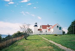
The light station consists of a lighthouse with integrated keeper's house, a barn, an oil house, and a bell house. The square brick lighthouse tower is 26 feet (7.9 m) in height (measured to the height of the lantern), with a square parapet surrounding the octagonal lantern house. The lantern house is capped by an octagonal roof with a spherical ventilator. A narrow single-story brick work room connects the tower to the keeper's house, a 2+12-story wood-frame structure with its main gable oriented north–south. Its main facade, facing west, is three bays wide, with the entrance set in the rightmost bay in an enclosed projecting gabled vestibule. A single story ell projects to the building's rear. [5]

Just east of the house stands a small barn, that is known to have been standing here since the 1890s. Also standing to the west is the small brick oilhouse, with a single door in one side, and pent gable ends on its roof. Further to the east stands the bell house, a roughly pyramidal wood-frame structure finished in wooden shingles. The oil house was built in 1897, the bell house in 1890. [5]

History

The Fort Point Light Station was authorized by Congress in 1834, and built on land purchased from William Clewley, the first keeper. It was the first river light in Maine, built at a time when traffic on the bay and river were increasing. The present tower and keeper's house were built in 1857 as a replacement for the first lighthouse. The original lamp was replaced in 1935, and electrified in 1950. It was automated in 1988 and remains an active aid to navigation.

The light's fourth order fresnel lens is one of only eight fresnel lenses still in use in Maine. [6] The original fog signal, a 1,200-pound (540 kg) cast iron bell, has been replaced by a fog horn in the same building. [3] [4] The lighthouse was leased to the state by the United States Coast Guard in 1989, and sold to it in 1998.

See also

Related Research Articles

<span class="mw-page-title-main">Spring Point Ledge Light</span> Lighthouse in Maine, US

Spring Point Ledge Light is a sparkplug lighthouse in South Portland, Maine, that marks a dangerous obstruction on the west side of the main shipping channel into Portland Harbor. It is now adjacent to the campus of Southern Maine Community College.

<span class="mw-page-title-main">West Quoddy Head Light</span> Lighthouse in Maine, United States

West Quoddy Head, in Quoddy Head State Park, Lubec, Maine, is the easternmost point of the contiguous United States. In 1808 a lighthouse was constructed at the site to guide ships through the Quoddy Narrows. The current tower, with distinctive red-and-white stripes, was constructed in 1858 and is an active aid to navigation. The 3rd order Fresnel lens is the only 3rd order and one of only eight Fresnel lenses still in use on the Maine Coast.

<span class="mw-page-title-main">Goat Island Light</span> Lighthouse in Maine, US

Goat Island Light is a lighthouse located off Cape Porpoise near Kennebunkport in southern Maine. Goat Island Light was established in 1835 to guard the entrance to Cape Porpoise Harbor. The original station was upgraded in 1859 to the current brick tower with a fifth order Fresnel lens. Keeper's quarters were added to the island in 1860. The light station was automated by the United States Coast Guard in 1990 and is currently active. The keepers dwellings and tower are leased to the Kennebunkport Conservation Trust. Goat Island Light can be seen from shore in Cape Porpoise Harbor just off State Route 9 north of Kennebunkport or is viewable by boat. The island is currently closed to the public except by special arrangement.

<span class="mw-page-title-main">Alki Point Light</span> Lighthouse

The Alki Point Light is an active aid to navigation located on Puget Sound's Alki Point, the southern entrance to Seattle's Elliott Bay, King County, Washington. It is listed as Alki Point Light number 16915 in the USCG light lists.

<span class="mw-page-title-main">Point Robinson Light</span> Lighthouse

The Point Robinson Light is an operational aid to navigation and historic lighthouse on Puget Sound, located at Point Robinson, the easternmost point of Maury Island, King County, in the U.S. state of Washington. The site was listed on the National Register of Historic Places in 2004.

<span class="mw-page-title-main">Long Point Light</span> Lighthouse in Massachusetts, United States

Long Point Light Station is a historic lighthouse at the northeast tip of Long Point in Provincetown, Massachusetts. As a navigational aid, it marks the southwest edge of the entrance to Provincetown Harbor. The United States Coast Guard Light List describes it simply as a "white square tower". The light it casts is green, occulting every 4 seconds, and, at a focal height of 35.5 feet (10.8 m) above mean sea level, has a visible range of 8 nautical miles. When the weather affords low-visibility, one can hear the station's fog horn – sounding a single blast for two seconds, and repeating every 15 seconds – as it seems to call out for its nearly-identical closest neighbor, the Wood End Light.

<span class="mw-page-title-main">Tarpaulin Cove Light</span> Lighthouse

The Tarpaulin Cove Light is a historic lighthouse on Naushon Island, one of the Elizabeth Islands of southern Massachusetts. It is located in the town of Gosnold, Massachusetts. Built on the site of a light station first established privately in the 18th century, the current tower dates from 1891. A keeper's house built at the same time has not survived. The light is 78 feet (24 m) above Mean High Water, and its white light is visible for 9 nautical miles.

<span class="mw-page-title-main">Owls Head Light</span> Lighthouse in Maine, US

The Owls Head Light is an active aid to navigation located at the entrance of Rockland Harbor on western Penobscot Bay in the town of Owls Head, Knox County, Maine. The lighthouse is owned by the U.S. Coast Guard and licensed to the American Lighthouse Foundation. It is the centerpiece of 13-acre (5.3 ha) Owls Head State Park and was added to the National Register of Historic Places as Owls Head Light Station in 1978.

<span class="mw-page-title-main">Marshall Point Light</span> Lighthouse in Maine, US

Marshall Point Light Station is a lighthouse at the entrance of Port Clyde Harbor in Port Clyde, Maine. The light station was established in 1832.

<span class="mw-page-title-main">Whitlocks Mill Light</span> Lighthouse in Maine, US

The Whitlocks Mill Light is a lighthouse on the south bank of the St. Croix River in Calais, Maine. It is the northernmost lighthouse in the state of Maine, and was the last light to be built in the state.

<span class="mw-page-title-main">Bear Island Light</span> Lighthouse in Maine, United States

Bear Island Light is a lighthouse on Bear Island near Mt. Desert Island, at the entrance to Northeast Harbor, Maine. It was first established in 1839. The present structure was built in 1889. It was deactivated in 1981 and relit as a private aid to navigation by the Friends of Acadia National Park in 1989. Bear Island Light was listed on the National Register of Historic Places as Bear Island Light Station on March 14, 1988.

<span class="mw-page-title-main">Egg Rock Light (Maine)</span> Lighthouse in Maine, US

Egg Rock Light is a lighthouse on Frenchman Bay, Maine. Built in 1875, it is one of coastal Maine's architecturally unique lighthouses, with a square tower projecting through the square keeper's house. Located on Egg Rock, midway between Mount Desert Island and the Schoodic Peninsula, it is an active aid to navigation, flashing red every 40 seconds. The light was listed on the National Register of Historic Places as Egg Rock Light Station in 1988.

<span class="mw-page-title-main">Great Duck Island Light</span> Lighthouse in Maine, US

Great Duck Island Light is a lighthouse on Great Duck Island in the town of Frenchboro, Maine, USA. Established in 1890, the light marks the approach to Blue Hill Bay and the southern approaches to Mount Desert Island on the central coast of Maine. The light was listed on the National Register of Historic Places as Great Duck Island Light Station on March 14, 1988. The light is an active aid to navigation maintained by the United States Coast Guard; the property is owned by the College of the Atlantic, which operates a research station there.

<span class="mw-page-title-main">Heron Neck Light</span> Lighthouse in Maine, US

Heron Neck Light is a lighthouse on Green's Island in Vinalhaven, Maine at the south end of Penobscot Bay. It was established in 1854 as an aid to navigation for Vinalhaven's main port, and for the Hurricane Channel extending northwest from Heron's Neck. The light was automated in 1984. It was listed on the National Register of Historic Places as Heron Neck Light Station on January 21, 1988.

<span class="mw-page-title-main">Indian Island Light</span> Lighthouse in Maine, US

Indian Island Light is a lighthouse on Indian Island on the eastern side of the entrance to Rockport Harbor, Maine. It was first established in 1850. The present structure was built in 1875. It was deactivated in 1934 and is now a private residence. It was listed on the National Register of Historic Places as Indian Island Light Station on March 23, 1988.

<span class="mw-page-title-main">Libby Island Light</span> Lighthouse in Maine, United States

Libby Island Light is a lighthouse on Libby Island, marking the mouth of Machias Bay, in Machiasport, Maine. The light station was established in 1817 and is an active aid to navigation; the present granite tower was built in 1823 and improved in 1848. Libby Island Light was listed on the National Register of Historic Places as Libby Island Light Station on June 18, 1976.

<span class="mw-page-title-main">Little River Light</span> Lighthouse in Maine, US

Little River Light is a lighthouse on an island at the mouth of the Little River, in Cutler, Maine. A light station was first established at this site in 1846, and the present structure was built in 1876. It is one of the only iron lighthouses in the state, and was listed on the National Register of Historic Places as Little River Light Station on March 14, 1988. The light station is now owned by the American Lighthouse Foundation, which offers overnight stays in the keeper's house, and occasional tours of the property.

<span class="mw-page-title-main">Petit Manan Light</span> Lighthouse in Maine, US

Petit Manan Light is a lighthouse on Petit Manan Island, Maine. The island is at the end of a series of ledges extending out from Petit Manan Point, between Dyer Bay and Pigeon Hill Bay, that projects into the Gulf of Maine.

<span class="mw-page-title-main">Whitehead Light</span> Lighthouse in Maine, US

Whitehead Light is a lighthouse on Whitehead Island, on Muscle Ridge Channel, in the southwestern entrance to Penobscot Bay, Maine. It is in the town of St.George. Established in 1804, it is one of Maine's oldest light stations, with its present tower built in 1852 to a design attributed to Alexander Parris. It was listed on the National Register of Historic Places as Whitehead Light Station on March 14, 1988. The property is now owned by not for profit Pine Island Camp. Whitehead light station offers to the public various stays at the light station from getaway weekends to learning retreats and renting the station as a vacation home. The light itself remains an active aid to navigation, maintained by the United States Coast Guard.

<span class="mw-page-title-main">Baker Island Light</span> Lighthouse in Maine, US

Baker Island Light is a lighthouse on Baker Island, Maine, which is part of Acadia National Park. The light station was established in 1828 as a guide to the southern entrance to Frenchman Bay. The present tower was built in 1855; the well-preserved tower, keeper's house, and associated outbuildings were listed on the National Register of Historic Places in 1988.

References

  1. 1 2 "National Register Information System". National Register of Historic Places . National Park Service. January 23, 2007.
  2. "Historic Light Station Information and Photography: Maine". United States Coast Guard Historian's Office. 2009-08-17. Archived from the original on 2017-05-01.
  3. 1 2 Light List, Volume I, Atlantic Coast, St. Croix River, Maine to Shrewsbury River, New Jersey (PDF). Light List. United States Coast Guard. 2009. p. 31.
  4. 1 2 "Fort Point State Historic Site". State of Maine, Department of Conservation, Bureau of Parks & Land. Retrieved 2014-09-22.
  5. 1 2 "NRHP nomination for Fort Point Light Station". National Park Service. Retrieved 2015-09-22.
  6. "Classical Lenses in Operation" (PDF). US Coast Guard. 2009-08-06. Archived from the original (PDF) on 2009-03-25.