Rangerville, Texas

Last updated

Rangerville, Texas
TXMap-doton-Rangerville.PNG
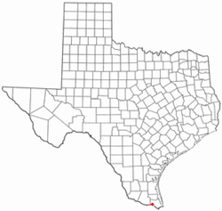
Location of Rangerville, Texas
Cameron County Rangerville.svg
Coordinates: 26°6′11″N97°44′20″W / 26.10306°N 97.73889°W / 26.10306; -97.73889
Country United States
State Texas
County Cameron
Area
  Total
3.5 sq mi (9.1 km2)
  Land3.5 sq mi (9.0 km2)
  Water0.04 sq mi (0.1 km2)
Elevation
52 ft (16 m)
Population
 (2020)
  Total
255
  Density73/sq mi (28/km2)
Time zone UTC-6 (Central (CST))
  Summer (DST) UTC-5 (CDT)
ZIP code
78586
Area code 956
FIPS code 48-60644 [1]
GNIS feature ID1375631 [2]

Rangerville is a village in Cameron County, Texas, United States. It was incorporated in 1958. The population was 255 at the 2020 census, up from 289 at the 2010 census. [3]

Contents

Rangerville is part of the Brownsville–Harlingen–Raymondville and the Matamoros–Brownsville metropolitan areas.

Geography

Rangerville is located in southwestern Cameron County at 26°6′11″N97°44′20″W / 26.10306°N 97.73889°W / 26.10306; -97.73889 (26.103104, -97.738982). [4] It is 7 miles (11 km) southwest of the center of Harlingen and 4 miles (6 km) north of the Rio Grande.

According to the United States Census Bureau, the village had a total area of 3.5 square miles (9.1 km2), of which 3.5 square miles (9.0 km2) are land and 0.04 square miles (0.1 km2), or 1.50%, is covered by water. [3]

The village is governed by a mayor and two city commissioners; it has no taxes and provides no services.

Demographics

Historical population
CensusPop.Note
2020 255
U.S. Decennial Census [5]
1850–1900 [6] 1910 [7]
1920 [8] 1930 [9] 1940 [10]
1950 [11] 1960 [12] 1970 [13]
1980 [14] 1990 [15] 2000 [16]
2010 [17]

2020 census

Rangerville racial composition [18]
(NH = Non-Hispanic) [a]
RaceNumberPercentage
White (NH)249.41%
Black or African American (NH)10.39%
Asian (NH)10.39%
Some Other Race (NH)10.39%
Mixed/Multi-Racial (NH)31.18%
Hispanic or Latino 22588.24%
Total255

As of the 2020 United States census, there were 255 people, 62 households, and 17 families residing in the village.

2000 census

As of the census [1] of 2000, 203 people, 57 households, and 47 families were residing in the village. The population density was 57.6 inhabitants per square mile (22.2/km2). The 66 housing units averaged 18.7/sq mi (7.2/km2). The racial makeup of the village was 65.02% White, 3.45% African American, 29.56% from other races, and 1.97% from two or more races. Hispanics or Latinos of any race were 77.34% of the population.

Of the 57 households, 38.6% had children under the age of 18 living with them, 70.2% were married couples living together, 8.8% had a female householder with no husband present, and 15.8% were not families. About 12.3% of all households were made up of individuals, and 3.5% had someone living alone who was 65 years of age or older. The average household size was 3.56, and the average family size was 4.00.

In the village, the age distribution was 30.5% under 18, 10.3% from 18 to 24, 25.6% from 25 to 44, 25.6% from 45 to 64, and 7.9% who were 65 or older. The median age was 33 years. For every 100 females, there were 101.0 males. For every 100 females age 18 and over, there were 95.8 males.

The median income for a household in the village was $30,357, and for a family was $30,357. Males had a median income of $25,781 versus $22,500 for females. The per capita income for the village was $18,185. About 28.6% of families and 32.6% of the population were below the poverty line, including 44.3% of those under the age of 18 and 54.5% of those 65 or over.

Education

Rangerville is located in the San Benito Consolidated Independent School District.

In addition, South Texas Independent School District operates magnet schools that serve the community.

Related Research Articles

<span class="mw-page-title-main">Arroyo Colorado Estates, Texas</span> CDP in Texas, United States

Arroyo Colorado Estates is a census-designated place (CDP) in Cameron County, in the U.S. state of Texas. The population was 997 at the 2010 census. It is part of the Brownsville–Harlingen Metropolitan Statistical Area.

<span class="mw-page-title-main">Cameron Park, Texas</span> CDP in Texas, United States

Cameron Park is a census-designated place (CDP) in Cameron County, Texas, United States. The population was 6,099 at the 2020 census. It is part of the Brownsville–Harlingen Metropolitan Statistical Area.

<span class="mw-page-title-main">El Camino Angosto, Texas</span> Census-designated place in Texas, United States

El Camino Angosto is a census-designated place (CDP) in Cameron County, Texas, United States. The population was 186 at the 2020 census. It is part of the Brownsville–Harlingen Metropolitan Statistical Area.

<span class="mw-page-title-main">Grand Acres, Texas</span> Census-designated place in Texas, United States

Grand Acres is a census-designated place (CDP) in Cameron County, Texas, United States. The population was 49 at the 2010 census. It is part of the Brownsville–Harlingen Metropolitan Statistical Area.

<span class="mw-page-title-main">Green Valley Farms, Texas</span> Census-designated place in Texas, United States

Green Valley Farms is a census-designated place (CDP) in Cameron County, Texas, United States. The population was 655 at the 2020 census, down from 1,272 at the 2010 census. It is part of the Brownsville–Harlingen Metropolitan Statistical Area.

<span class="mw-page-title-main">La Feria North, Texas</span> Census-designated place in Texas, United States

La Feria North is a census-designated place (CDP) in Cameron County, Texas, United States. The population was 225 at the 2020 census. It is part of the Brownsville–Harlingen Metropolitan Statistical Area.

<span class="mw-page-title-main">La Paloma, Texas</span> Census-designated place in Texas, United States

La Paloma is a census-designated place (CDP) in Cameron County, Texas, United States. The population was 2,903 at the 2010 census, up from 354 at the 2000 census, when it was drawn to cover a much smaller area. By the 2020 census, the population further increased to 3,218. It is part of the Brownsville–Harlingen Metropolitan Statistical Area.

<span class="mw-page-title-main">Laguna Heights, Texas</span> Census-designated place in Texas, United States

Laguna Heights is a census-designated place (CDP) in Cameron County, Texas, United States. The population was 962 at the 2020 census, significantly down from 3,488 at the 2010 census.

<span class="mw-page-title-main">Lasana, Texas</span> Census-designated place in Texas, United States

Lasana is a census-designated place (CDP) in Cameron County, Texas, United States. The population was 84 at the 2010 census, down from 135 at the 2000 census. It is part of the Brownsville–Harlingen Metropolitan Statistical Area.

<span class="mw-page-title-main">Laureles, Texas</span> CDP in Texas, United States

Laureles is a census-designated place (CDP) in Cameron County, Texas, United States. The population was 4,111 at the 2020 census. It is part of the Brownsville–Harlingen Metropolitan Statistical Area. Laureles is an area between Los Fresnos and San Benito.

<span class="mw-page-title-main">Lozano, Texas</span> Census-designated place in Texas, United States

Lozano is a census-designated place (CDP) in Cameron County, Texas, United States. The population was 404 at the 2010 census, up from 324 at the 2000 census. By the 2020 census, the population went drastically down to 174. It is part of the Brownsville–Harlingen Metropolitan Statistical Area.

<span class="mw-page-title-main">Palm Valley, Cameron County, Texas</span> City in Texas, United States

Palm Valley is a city in Cameron County, Texas, United States. The population was 1,413 at the 2020 census. It is part of the Brownsville–Harlingen–Raymondville and the Matamoros–Brownsville metropolitan areas.

<span class="mw-page-title-main">Port Isabel, Texas</span> City in Texas, United States

Port Isabel is a city in Cameron County, Texas, United States. It is part of the Brownsville–Harlingen–Raymondville and the Matamoros–Brownsville metropolitan areas. The population was 5,028 at the 2020 census.

<span class="mw-page-title-main">Reid Hope King, Texas</span> Census-designated place in Texas, United States

Reid Hope King is a census-designated place (CDP) in Cameron County, Texas, United States. The population was 667 at the 2020 census. It is part of the Brownsville–Harlingen Metropolitan Statistical Area.

<span class="mw-page-title-main">San Pedro, Texas</span> Census-designated place in Texas, United States

San Pedro is a census-designated place (CDP) in Cameron County, Texas, United States. The population was 442 at the 2020 census. It is part of the Brownsville–Harlingen Metropolitan Statistical Area.

<span class="mw-page-title-main">Santa Maria, Texas</span> Census-designated place in Texas, United States

Santa Maria is a census-designated place (CDP) in Cameron County, Texas, United States. The population was 651 at the 2020 census. It is part of the Brownsville–Harlingen Metropolitan Statistical Area.

<span class="mw-page-title-main">Solis, Texas</span> Census-designated place in Texas, United States

Solis is a census-designated place (CDP) in Cameron County, Texas, United States. The population was 722 at the 2020 census. It is part of the Brownsville–Harlingen Metropolitan Statistical Area.

<span class="mw-page-title-main">Villa del Sol, Texas</span> Census-designated place in Texas, United States

Villa del Sol is a census-designated place (CDP) in Cameron County, Texas, United States. The population was 153 at the 2020 census. It is part of the Brownsville–Harlingen Metropolitan Statistical Area.

<span class="mw-page-title-main">Villa Pancho, Texas</span> Census-designated place in Texas, United States

Villa Pancho is a census-designated place (CDP) in Cameron County, Texas, United States. The population was 467 at the 2020 census, up from 788 at the 2010 census. It is part of the Brownsville–Harlingen Metropolitan Statistical Area.

<span class="mw-page-title-main">Yznaga, Texas</span> Census-designated place in Texas, United States

Yznaga is a census-designated place (CDP) in Cameron County, Texas, United States. The population was 108 at the 2020 census. It is part of the Brownsville–Harlingen Metropolitan Statistical Area.

References

  1. 1 2 "U.S. Census website". United States Census Bureau . Retrieved January 31, 2008.
  2. "US Board on Geographic Names". United States Geological Survey. October 25, 2007. Retrieved January 31, 2008.
  3. 1 2 "Geographic Identifiers: 2010 Census Summary File 1 (G001): Rangerville village, Texas". U.S. Census Bureau, American Factfinder. Archived from the original on February 13, 2020. Retrieved July 8, 2015.
  4. "US Gazetteer files: 2010, 2000, and 1990". United States Census Bureau. February 12, 2011. Retrieved April 23, 2011.
  5. "Decennial Census by Decade". United States Census Bureau .
  6. "1900 Census of Population - Population of Texas By Counties And Minor Civil Divisions" (PDF). United States Census Bureau .
  7. "1910 Census of Population - Supplement for Texas" (PDF). United States Census Bureau .
  8. "1920 Census of Population - Number of Inhabitants - Texas" (PDF). United States Census Bureau .
  9. "1930 Census of Population - Number of Inhabitants - Texas" (PDF). United States Census Bureau .
  10. "1940 Census of Population - Number of Inhabitants - Texas" (PDF). United States Census Bureau .
  11. "1950 Census of Population - Number of Inhabitants - Texas" (PDF). United States Census Bureau .
  12. "1960 Census of Population - Number of Inhabitants - Texas" (PDF). United States Census Bureau .
  13. "1970 Census of Population - Number of Inhabitants - Texas" (PDF). United States Census Bureau .
  14. "1980 Census of Population - Number of Inhabitants - Texas" (PDF). United States Census Bureau .
  15. "1990 Census of Population - Population and Housing Unit Counts - Texas" (PDF). United States Census Bureau .
  16. "2000 Census of Population - Population and Housing Unit Counts - Texas" (PDF). United States Census Bureau .
  17. "2010 Census of Population - Population and Housing Unit Counts - Texas" (PDF). United States Census Bureau .
  18. "Explore Census Data". data.census.gov. Retrieved May 21, 2022.
  19. https://www.census.gov/ [ not specific enough to verify ]
  20. "About the Hispanic Population and its Origin". www.census.gov. Retrieved May 18, 2022.
  1. Note: the US Census treats Hispanic/Latino as an ethnic category. This table excludes Latinos from the racial categories and assigns them to a separate category. Hispanics/Latinos can be of any race. [19] [20]