
Red Post is a crossroads near Launcells in Cornwall, England. It is on the A3072 Holsworthy to Stratton road where it is crossed by the B3254 road. [1]
Red Post is a crossroads near Launcells in Cornwall, England. It is on the A3072 Holsworthy to Stratton road where it is crossed by the B3254 road. [1]

Carrick was a local government district in Cornwall, England, United Kingdom. Its council was based in Truro.

North Cornwall is an area of Cornwall, England, United Kingdom. It is also the name of a former local government district, which was administered from Bodmin and Wadebridge 50.516°N 4.835°W. Other towns in the area are Launceston, Bude, Padstow, and Camelford.
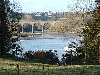
The River Lynher flows through east Cornwall, England, and enters the River Tamar at the Hamoaze, which in turn flows into Plymouth Sound.

The Truro River is a river in the city of Truro in Cornwall, England, UK. It is the product of the convergence of the two rivers named Kenwyn and Allen which run under the city: the Truro River flows into the River Fal, estuarial waters where wildlife is abundant, and then out into the Carrick Roads. The river is navigable up to Truro.

The A390 is a road in Cornwall and Devon, England. It runs from Tavistock to 5 miles (8.0 km) north west of the city of Truro. Starting in Tavistock, it heads south-westwards towards Liskeard, crossing over the River Tamar and into Cornwall, then through Gunnislake and Callington. Immediately before Liskeard, it merges with the A38 north of the town. It diverges from the A38 at Dobwalls, where it then runs in a south-westerly direction to Truro via Lostwithiel, St. Blazey, and St Austell. It then forms an upside down elongated square loop, and bypasses Truro City Centre. It then heads north west out of the city, where it forms the main corridor into Truro from the west. It passes the Royal Cornwall Hospital and skirts the village of Threemilestone, before linking up with the A30 road at Chiverton Cross, where the A390 terminates. Chiverton Cross is where the A390 trunk road from Truro and the B3277 to St Agnes meet the east-west A30 trunk road. Before the A390 was rerouted away from Chacewater it ended at its junction with the A30 at Scorrier.
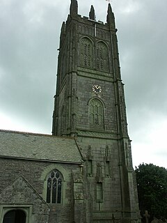
Probus is a civil parish and village in Cornwall, England, in the United Kingdom. It is famous for having the tallest church tower in Cornwall. The tower is 129 feet (39 m) high, and richly decorated with carvings. The place name originates from the church's dedication to Saint Probus. The parish population at the 2011 census was 2,299, whereas the ward population taken at the same census was 3,953.

St Just in Roseland is a village and civil parish in Cornwall, England, United Kingdom. The village is 6 miles (9.7 km) south of Truro and 2 miles (3 km) north of St Mawes, a small town within the parish of St Just in Roseland. The 2011 Census recorded the parish population as 1,158.

Hingston Down is a hill not far from Gunnislake in Cornwall, England, United Kingdom. It should not be confused with the Hingston Down at 50.661°N 3.746°W, a hill spur about a mile east of the town of Moretonhampstead in the neighbouring county of Devon.
There are seventeen disused railway stations on the Cornish Main Line between Plymouth in Devon and Penzance in Cornwall, England. The remains of nine of these can be seen from passing trains. While a number of these were closed following the so-called "Beeching Axe" in the 1960s, many of them had been closed much earlier, the traffic for which they had been built failing to materialise.
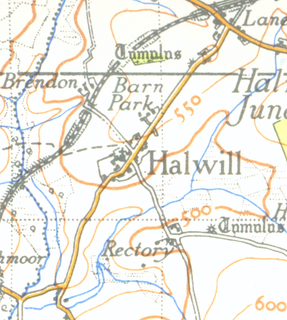
Halwill is a village in Devon, England just off the A3079 Okehampton to Holsworthy road. About a mile away on the main road is another settlement called Halwill Junction.
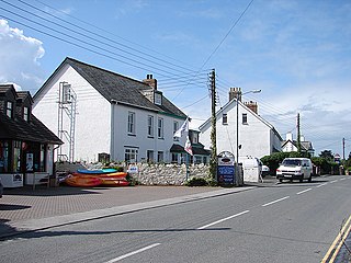
Splatt is a small settlement in north Cornwall, England, United Kingdom at grid reference SW 945 763. It is situated between Pityme and Rock although the buildings along the Rock Road are continuous.

Warleggan or Warleggon is a civil parish on the southern edge of Bodmin Moor in Cornwall, England, United Kingdom.

The River Ottery is a small river in northeast Cornwall, United Kingdom. The river is about twenty miles (32 km) long from its source southeast of Otterham to its confluence with the River Tamar at Nether Bridge, two miles (3.2 km) northeast of Launceston.

The De Lank River is a small river in north Cornwall, England. It is a tributary of the River Camel and is approximately nine miles (14.5 km) long from its source on Bodmin Moor to its confluence with the Camel two miles (3 km) south of St Breward.
Treskinnick Cross is a hamlet at Grid ref. SX2098 on the A39 main road near Poundstock in northeast Cornwall, England, United Kingdom.
Loggans Moor is a nature reserve and Site of Special Scientific Interest, noted for its biological characteristics, in west Cornwall, England, UK. It is located 1 mile north-east of the town of Hayle, off the A30 road.

Gulworthy is a hamlet and civil parish in Devon, England that adjoins the border with Cornwall. There are a group of buildings by the road junction Gulworthy Cross which constitute the centre of the parish. These are Gulworthy School, St Paul's Church and the Parish Hall. However it is part of the electoral ward of Tamarside. The population at the 2011 census was 1,622.

The B3306, also known as the West Cornwall Coast Road, is a major road of southwestern Cornwall. It connects St Ives in the east to St Just in the west, and eventually joins the A30 road to the northeast of Sennen in the southwest of the Penwith peninsula. This thirteen-mile road is often voted one of the greatest driving roads in the United Kingdom for its scenery, with most of the road having views both across the Bristol Channel to the north, and the Cornish Moorland to the south. It hugs the coastline for a great proportion of its length.

The River Seaton is a river in east Cornwall, England, UK which flows southwards for 11 miles (17 km) into the English Channel.

The River Lerryn is a river in east Cornwall, England, UK, a tributary of the River Fowey. The Lerryn is the largest of the tributaries which enter the estuary of the Fowey. The river is tidal up to the village of Lerryn. The landscape of the Lerryn catchment is rural and includes heathland, moorland and rough pasture in the upper reaches and broadleaf, coniferous and mixed plantation woodland in the lower. This catchment includes four SSSIs, including Redlake Meadows & Hoggs Moor. The Lerryn rises at Fairy Cross on the southern slopes of Bodmin Moor and flows south-southwest until it enters the Fowey estuary.
| Unitary authorities | |
|---|---|
| Major settlements |
|
| Rivers | |
| Topics | |
Coordinates: 50°49′14″N4°27′59″W / 50.820458°N 4.466344°W
| This Cornwall location article is a stub. You can help Wikipedia by expanding it. |