
Montague County is a county located in the U.S. state of Texas, established in 1857. As of the 2020 census, its population was 19,965. The county seat is Montague. The county was created in 1857 and organized the next year. It is named for Daniel Montague, a surveyor and soldier in the Mexican–American War.
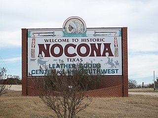
Nocona is a city along U.S. Highway 82 and State Highway 175 in Montague County, Texas, United States. The population was 3,033 at the 2010 census. The city, its lake, and its resurgence as a regional travel destination were featured in the June 2012 edition of Texas Highways magazine.

Quanah Parker was a war leader of the Kwahadi ("Antelope") band of the Comanche Nation. He was likely born into the Nokoni ("Wanderers") band of Tabby-nocca and grew up among the Kwahadis, the son of Kwahadi Comanche chief Peta Nocona and Cynthia Ann Parker, an Anglo-American who had been abducted as an eight-year-old child and assimilated into the Nokoni tribe. Following the apprehension of several Kiowa chiefs in 1871, Quanah Parker emerged as a dominant figure in the Red River War, clashing repeatedly with Colonel Ranald S. Mackenzie. With European-Americans hunting American bison, the Comanches' primary sustenance, into near extinction, Quanah Parker eventually surrendered and peaceably led the Kwahadi to the reservation at Fort Sill, Oklahoma.

The Chisholm Trail was a trail used in the post-Civil War era to drive cattle overland from ranches in Texas to Kansas railheads. The trail was established by Black Beaver, a Lenape guide and rancher, and his friend Jesse Chisholm, a Cherokee merchant. They collected and drove numerous cattle along the trail to Kansas, where they could be shipped east to achieve higher prices. The southern terminus was Red River Station, a trading post near the Red River along the northern border of Texas. The northern terminus was a trading post near Kansas City, Kansas. Chisholm owned both of these posts. In the years of the cattle drives, cowboys drove large herds from ranches across Texas to the Red River Station and then north to Kansas City.

The Cimarron River extends 698 miles (1,123 km) across New Mexico, Oklahoma, Colorado, and Kansas. The headwaters flow from Johnson Mesa west of Folsom in northeastern New Mexico. Much of the river's length lies in Oklahoma, where it either borders or passes through eleven counties. There are no major cities along its route. The river enters the Oklahoma Panhandle near Kenton, Oklahoma, crosses the corner of southeastern Colorado into Kansas, reenters the Oklahoma Panhandle, reenters Kansas, and finally returns to Oklahoma where it joins the Arkansas River at Keystone Reservoir west of Tulsa, Oklahoma, its only impoundment. The Cimarron drains a basin that encompasses about 18,927 square miles (49,020 km2).

Fort Davis National Historic Site is a United States National Historic Site located in the unincorporated community of Fort Davis, Jeff Davis County, Texas. Located within the Davis Mountains of West Texas, the historic site was established in 1961 to protect one of the best remaining examples of a United States Army fort in the southwestern United States.

Fort Chadbourne was a fort established by the United States Army on October 28, 1852, in what is now Coke County, Texas, to protect the western frontier and the Butterfield Overland Mail route. It was named after Lt. T.L. Chadbourne, who was killed in the Battle of Resaca de la Palma. It was defended by Companies A and K of the 8th U.S. Infantry. During the early days of the American Civil War, the fort surrendered to the Confederates on February 28, 1861, even before the Confederate shelling of Fort Sumter, South Carolina, but was reoccupied by federal troops from 1865 to 1867.

The Great Western Cattle Trail is the name used today for a cattle trail established during the late 19th century for moving beef stock and horses to markets in eastern and northern states. It is also known as the Western Trail, Fort Griffin Trail, Dodge City Trail, Northern Trail and Texas Trail. It ran west of and roughly parallel to the better known Chisholm Trail into Kansas, reaching an additional major railhead there for shipping beef to Chicago, or longhorns and horses continuing on further north by trail to stock open-range ranches in the Dakotas, Wyoming, Montana, and two provinces in Canada. A full-length drive from the trailhead south of Bandera, Texas took almost one hundred days to reach its destination in Kansas.

Spanish Fort is an unincorporated community in north-central Montague County, Texas, United States. According to the Handbook of Texas, the community had a population of 50 in 2000.
Belcherville is an unincorporated community in Montague County, Texas, United States. According to the Handbook of Texas, the community had a population of 34 in 2000.
Fort Richardson was a United States Army installation located in present-day Jacksboro, Texas. Named in honor of Union General Israel B. Richardson, who died in the Battle of Antietam during the American Civil War, it was active from 1867 to 1878. Today, the site, with a few surviving buildings, is called Fort Richardson State Park, Historic Site and Lost Creek Reservoir State Trailway. It was designated a National Historic Landmark in 1963 for its role in securing the state's northern frontier in the post-Civil War era.
Marysville is an unincorporated community in northwestern Cooke County, Texas, United States. It lies approximately three miles from the Texas-Oklahoma border.
The Battle of Middle Boggy Depot, also known as the Battle of Middle Boggy River or simply Battle of Middle Boggy, took place on February 13, 1864 in Choctaw Indian Territory, 4 miles (6.4 km) south of what is now Allen in Pontotoc County, Oklahoma. Advancing down the Dragoon Trail toward Fort Washita, Union Colonel William A. Phillips sent out an advance of approximately 350 men from the 14th Kansas Cavalry and two howitzers to attack a Confederate outpost guarding the Trail's crossing of Middle Boggy River. The Confederate force was led by Captain Jonathan Nail and composed of one company of the First Choctaw and Chickasaw Cavalry, a detachment of the 20th Texas Cavalry and part of the Seminole Battalion of Mounted Rifles. The outpost was about 12 miles (19 km) from Muddy Boggy Depot, which was held by the Confederates. The Encyclopedia of Oklahoma History and Culture says that the battlefield was 15 miles northeast of the depot, whereas the battlefield marker says the distance was 12 miles. The Confederate force at the outpost, consisting of 90 poorly armed men, were caught off guard when Willetts attacked them. Outnumbered and outgunned, the Confederates held off the Union cavalry attack for approximately 30 minutes before retreating to the rest of Lt. Col. John Jumper's Seminole Battalion, who were not at the main skirmish. The Confederates retreated 45 miles (72 km) southwest down the Dragoon Trail. The Union advance continued south toward Ft. Washita the next day, but when the expected reinforcements did not arrive Philips' Expedition into Indian Territory stalled on February 15, near old Stonewall.
Preston, also known as Preston Bend, is an unincorporated community and census-designated place located on the Red River in Grayson County, Texas, United States. It grew in the 19th century at the intersection of several military and trade roads and was an important crossing on the Shawnee cattle trail. Preston lost prominence after the MK&T railroad bypassed the town to the east, leading to a decline in traveler and cattle drive traffic. Much of its former town site is submerged beneath the waters of Lake Texoma. Its population was 2,096 as of the 2010 census.
White Horse was a chief of the Kiowa. White Horse attended the council between southern plains tribes and the United States at Medicine Lodge in southern Kansas which resulted in the Medicine Lodge Treaty. Despite his attendance at the treaty signing he conducted frequent raids upon other tribes and white settlers. Follower of such elders as Guipago, Satanta and old Satank, he was often associated with Big Tree.

Black Beaver or Se-ket-tu-may-qua was a trapper and interpreter who worked for the American Fur Company. He served as a scout and guide as he was fluent in English, as well as several European and Native American languages. He is credited with establishing the California and Chisholm trails.

Travis County has had two locations named Montopolis. The first was during the Republic of Texas period north of the Colorado River. The second is today's Montopolis neighborhood in Austin, Texas south of the river. Located southeast of the city's urban core, today's neighborhood is in ZIP code 78741. Montopolis is bounded by Lake Lady Bird on the north, by Grove Street and the Pleasant Valley neighborhood on the west, to the south by Texas State Highway 71, and by U.S. Route 183 on the east. The southeast corner abuts Austin-Bergstrom International Airport. Montopolis is in City Council District 3.

Waldeck is a ghost town in Marion County, Kansas, United States. It is currently a ghost town that was located approximately 3.5 miles north of Lehigh next to a railroad. No buildings remain of this former community.

Stonewall Saloon or The Museum of the Stonewall Saloon is an authentic western saloon located in Saint Jo, Texas. The tavern was named as acknowledgment of Stonewall Jackson as American Civil War exiles appealed for sanctuary in what was termed "Indian country." The saloon was established in 1873 during the eminence of the cattle drive era exemplary of the late nineteenth century Old West.

Blockhouse on Signal Mountain is within the Fort Sill Military Reservation, north of Lawton, Oklahoma. The rock architecture is located along Mackenzie Hill Road within the Fort Sill West Range being the Oklahoma administrative division of Comanche County.


