
Liverpool is a suburb of South Western Sydney, in the state of New South Wales, Australia. It is located approximately 31 kilometres (19 mi) south-west of the Sydney CBD. Liverpool is the administrative seat of the local government area of the City of Liverpool and is situated in the Cumberland Plain.

Campbelltown is a suburb located on the outskirts of the metropolitan area of Sydney, New South Wales, Australia. It is located in Greater Western Sydney 53 kilometres (33 mi) south-west of the Sydney central business district by road. Campbelltown is the administrative seat of the local government area of the City of Campbelltown. It is also acknowledged on the register of the Geographical Names Board of New South Wales as one of only four cities within the Sydney metropolitan area.
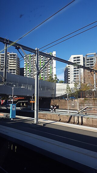
Redfern is an inner southern suburb of Sydney located 3 kilometres (1.9 mi) south of the Sydney central business district and is part of the local government area of the City of Sydney. Strawberry Hills is a locality on the border with Surry Hills. The area experienced the process of gentrification and is subject to extensive redevelopment plans by the state government, to increase the population and reduce the concentration of poverty in the suburb and neighbouring Waterloo.

Balmain is a suburb in the Inner West of Sydney, New South Wales, Australia. Balmain is located two kilometres west of the Sydney central business district, in the local government area of the Inner West Council.

Ryde is a suburb of Sydney, New South Wales, Australia. Ryde is located 13 km north-west of the Sydney central business district and 8 km east of Parramatta. Ryde is the administrative centre of the local government area of the City of Ryde and part of the Northern Sydney region. It lies on the north bank of the Parramatta River. People from Ryde are colloquially known as Ryders, Rydiens or Rydemen.

Queanbeyan is a city in south-eastern New South Wales, Australia, located adjacent to the Australian Capital Territory in the Southern Tablelands region. Located on the Queanbeyan River, the city is the council seat of the Queanbeyan-Palerang Regional Council. At the 2021 census, the Queanbeyan part of the Canberra–Queanbeyan built-up area had a population of 37,511.

Randwick is a suburb in the Eastern Suburbs of Sydney, in the state of New South Wales, Australia. Randwick is located 6 kilometres south-east of the Sydney central business district and is the administrative centre for the local government area of the City of Randwick. The postcode is 2031.

The Eastern Suburbs is the eastern metropolitan region of Sydney, New South Wales, Australia.

Glebe is an inner-western suburb of Sydney in New South Wales. Glebe is located 3 kilometres (1.9 mi) southwest of the Sydney central business district and is part of the local government area of the City of Sydney, in the Inner West region.

The South Sydney Rabbitohs are an Australian professional rugby league football club based in the Sydney suburb of Redfern that competes in the National Rugby League (NRL). They are often referred to as Souths or the Bunnies.

Auburn is a Western Sydney suburb in the state of New South Wales, Australia. Auburn is located 16 kilometres (9.9 mi) west of the Sydney central business district and is in the local government area of Cumberland City Council, having previously been the administrative centre of Auburn Council. The suburb was named after Oliver Goldsmith's poem The Deserted Village, which describes 'Auburn' in England as the "loveliest village of the plain".

Paddington is an upscale Eastern Suburb of Sydney, in the state of New South Wales, Australia. Located 3 kilometres (1.9 mi) east of the Sydney central business district, Paddington lies across two local government areas. The portion south of Oxford Street lies within the City of Sydney, while the portion north of Oxford Street lies within the Municipality of Woollahra. It is often colloquially referred to as "Paddo".

Alexandria is an inner southern suburb of Sydney, New South Wales, Australia. Alexandria is located 5 kilometres south of the Sydney central business district and is part of the local government area of the City of Sydney. The postcode is 2015.

Leeton is a town located in the Riverina region of New South Wales, Australia. It is situated in the Murrumbidgee Irrigation Area. It is the administrative centre of the Leeton Shire Council local government area, which includes neighbouring suburbs, towns and localities such as Yanco, Wamoon, Whitton, Gogeldrie, Stanbridge and Murrami.
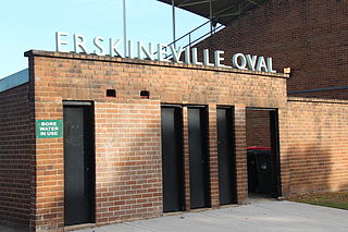
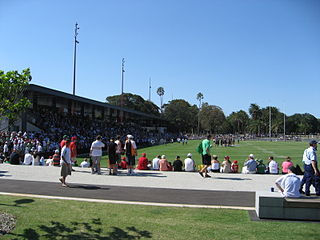
Erskineville Oval is a sporting venue in Erskineville, Sydney, Australia. Originally developed and opened in 1885 as Macdonaldtown Park, it was later renamed in 1892 to its current form with the municipality name change of the local government body. At approximately a capacity of 5000 spectators, previously 2000 Erskineville Oval was formerly an AFL venue as of 1903 when the NSW Australian Football League was founded. From 1913, the ground become a rugby venue as well, in which it has since hosted professional teams such as Newtown and the South Sydney Rabbitohs.
Redfern Oval is an Australian football ground, in the Sydney suburb of Redfern, New South Wales, Australia. The South Sydney Rabbitohs Rugby League Football Club played at Redfern Oval between 1948 and 1987. Rabbitoh supporters often refer to Redfern Oval as "The Holy Land".

The Callan Park Hospital for the Insane (1878–1914) is a heritage-listed former insane asylum, which was subsequently, for a time, used as a college campus, located in the grounds of Callan Park, an area on the shores of Iron Cove in Lilyfield, a suburb of Sydney, New South Wales, Australia. In 1915, the facility was renamed as the Callan Park Mental Hospital and, again in 1976, to Callan Park Hospital. Since 1994, the facility has been formally known as Rozelle Hospital. In April 2008, all Rozelle Hospital services and patients were transferred to Concord Hospital. The Callan Park Act, 2002 (NSW) restricts future uses of the site to health, tertiary education and community uses.
The Paddington Town Hall is a heritage-listed former town hall building located at 249 Oxford Street in the inner eastern Sydney suburb of Paddington, in the City of Sydney local government area of New South Wales, Australia. Sir Henry Parkes laid its foundation stone in 1890 when Paddington was a separate municipality. It was designed by John Edward Kemp and built from 1890 to 1891, and remains a distinctive example of Victorian architecture in Sydney. The clock tower, completed in 1905, is 32 metres (105 ft) high and is a prominent landmark on the ridge of Oxford Street. It is also known as Town Hall and was added to the New South Wales State Heritage Register on 2 April 1999.

The Waterloo Town Hall is a heritage-listed town hall located in Waterloo, a suburb of Sydney, New South Wales, Australia. Located at 770 Elizabeth Street, it was built in 1880–82 in the Victorian Italianate architectural style with Second Empire elements by John Smedley, Edward Hughes and Ambrose Thornley. The town hall was the seat of Waterloo Municipal Council from 1882 to 1948 and since 1972 has been the Waterloo Library, a branch of the City of Sydney Library servicing Waterloo and Alexandria.

Redfern Park is a heritage-listed park at Elizabeth, Redfern, Chalmers and Phillip streets, Redfern, Sydney, Australia. It was designed by Charles O'Neill. It was added to the New South Wales State Heritage Register on 21 September 2018.


