Paddington Town Hall

Last updated

Paddington Town Hall
Paddington Town Hall.JPG
Paddington Town Hall
Location map Australia Sydney.png
Red pog.svg
Paddington Town Hall
Location in Greater Sydney
General information
Type Town hall
Architectural style Victorian Free Classical
Address249 Oxford Street, Paddington
Town or city Sydney, New South Wales
CountryAustralia
Coordinates 33°53′06″S151°13′33″E / 33.885125°S 151.225792°E / -33.885125; 151.225792
Current tenants
Construction started8 November 1890 (1890-11-08)
Completed1891 (1891)
Opened3 October 1891 (1891-10-03)
RenovatedAugust 1905 (1905-08)
Client Municipality of Paddington
Owner City of Sydney
Height
Tip32-metre (105 ft) clock tower
Design and construction
Architect(s)John Edward Kemp
Main contractorR. Steele
Website
cityofsydney.nsw.gov.au
Official namePaddington Town Hall; Town Hall
TypeState heritage (built)
Criteria a., c., d.
Designated2 April 1999
Reference no.561
TypeHall Town Hall
CategoryCommunity Facilities

The Paddington Town Hall is a heritage-listed former town hall building located at 249 Oxford Street in the inner eastern Sydney suburb of Paddington, in the City of Sydney local government area of New South Wales, Australia. Sir Henry Parkes laid its foundation stone in 1890 when Paddington was a separate municipality. It was designed by John Edward Kemp and built from 1890 to 1891, and remains a distinctive example of Victorian architecture in Sydney. The clock tower, completed in 1905, is 32 metres (105 ft) high and is a prominent landmark on the ridge of Oxford Street. [1] It is also known as Town Hall and was added to the New South Wales State Heritage Register on 2 April 1999. [2]

Contents

History

History of the area

This suburb, which took its name from the London borough, lies in what were once paddocks adjacent to Victoria Barracks. It was the first of the early Sydney suburbs that was not self-sufficient - its inhabitants, unlike those of Balmain or Newtown, where work was available in local industries, had to go away each day to their places of employment. Development of the eastern suburbs of Edgecliff, Double Bay, Point Piper and Woollahra surrounded this area with wealthy people's homes so this small hilly suburb lost all hope of harbour views. [2]

The area developed after a road was constructed to link up with a pilot station that was to be built at Watsons Bay (Old South Head Road). John Palmer, the settlement's commissary, refused to allow people to cross his land grant ('Woolloomooloo'), so the road had to follow a roundabout way through Paddington to bypass his 40 hectares (100 acres). Only a handful of workers lived in the area, and it was not until 1838, when it was decided to build a new military barracks in Paddington, that life came to the area. [2]

From 1848 when Victoria Barracks had been opened (designed by Lt.-Col. George Barney) and homes for the soldiers and their families had been erected, Paddington began to assume a real identity...The (barracks site) land was sandy - in fact a huge sandhill was located on the western side of the Greens Road area, and the foundation trenches had to be dug very deep, to locate firm stone for the foundations. Stone was mostly quarried in the area: the stonemasons were free settlers who had worked on erection of the Customs House at what was then Semi-Circular Quay. [2]

Once the soldiers and their families moved here, shopkeepers followed. Builders moved into the area and put up 3,800 houses between 1860 and 1890. These terraces give today's Paddington its air of individuality. The first school in the area was opened in the Presbyterian manse in Oxford Street, built in 1845. [2]

It is hard to imagine that in 1822 the mansion Juniper Hall (the opposite southern corner of Oxford Street from the Reservoir site) stood alone, without the many neighbours it has today. Set in a flagged garden, it had attic windows that gave panoramic views to Rushcutters Bay and Botany Bay. Juniper Hall was built for Robert Cooper, distiller and emancipist merchant, who with partners James Underwood and Francis Ewen Forbes, had received 40 hectares (100 acres) from Governor Brisbane in c.1818, covering the whole of north Paddington, and they agreed to erect three mansions and a distillery there. A distillery was built at the foot of Cascade Street near Taylor Square and Cooper bought out his partners, and only Juniper Hall was erected. The Coopers were part of the social scene of their day and entertained many notables of that time. After they left the house it was renamed Ormond House to dissociate itself from the gin image and passed through many hands, gradually becoming smothered by the building of small shops in front of the house. Latterly it has been restored by the National Trust and has had a variety of uses. [2]

Today few of the area's original working class residents remain, as the suburb's proximity to the city has made it popular with business and professional people who prefer inner-city living in this historic area. The shopping centre, concentrated on the north side of Oxford Street, has also changed from one serving local needs to one of cafes, speciality shops and boutiques. Much of this is related to the changing population and the Village Bazaar, or Paddington Markets. The bazaar, which has operated since the mid-1970s, draws visitors from all over the city and has contributed to Paddington's development as one of Sydney's favourite tourist spots, along with Bondi Beach and The Rocks. [2] [3]

Paddington Council

The residents of Paddington raised a petition of 172 signatures in September 1859 requesting incorporation as a district. The proposed boundary was the Sydney Common to the south and New South Head Road to the north. The area was said to include 1,000 houses with 3,000 residents. [2]

The Council held their first meeting on 25 May 1860 with nine councillors and a chairman. The first three meetings were held in the Paddington Inn before Council resolved to rent Mr. Logan's house next door for 12 months at 15 shillings a week. Meetings continued to be held at the house until the first Town Hall was built on the current site of the Royal Women's Hospital in Oxford Street in 1866. [2]

With a budget of £ 2000 the Council concentrated on maintaining roads, including kerbing and guttering, and erecting gas lamps. By 1867 Paddington had sufficient population to be elevated to a Borough and the Chairman became a Mayor. Paddington continued to prosper and in 1890 was receiving revenue second only to Balmain Council. [2]

Fifty years from its inception, in 1909, the population had risen to 26,000 in 4,800 houses and expenditure was at £ 21,000. During the 1890s depression and difficult years of the early 20th century Paddington declined and was characterised as a slum. In 1949 Paddington Council was subsumed by the City of Sydney. The last remnants of Paddington Council were removed in 1967 when the original boundary was divided between the Municipality of Woollahra and the City of Sydney. [2]

Paddington Town Hall

Aspiring Town Clerk C. Hellmrich obtained the land for the Paddington Town Hall and argued for a new Hall on the site. The design was the subject of an international architectural competition with thirty submissions. Although a design specification was that the building could be constructed for 9000 pounds, none of the submissions were likely to meet this criteria. John Edward Kemp was the winner with an Italian Renaissance style building. Tenders confirmed that the scheme could not be built for 9000 pounds and estimates instead stood at 13,500 pounds. A loan was obtained from an overseas institution to allow construction. [2]

The foundation stone laid by Sir Henry Parkes Paddington town hall foundation stone.jpg
The foundation stone laid by Sir Henry Parkes

Situated at the highest point on the Oxford Street ridge, the town hall's foundation stone was laid on 8 November 1890 by Sir Henry Parkes and was opened with great fanfare on 3 October 1891 by the Governor, The Earl of Jersey. [2] [4] [5] The first major alteration to the Town Hall occurred in 1904–1905, when the clock tower was erected in commemoration of the coronation of King Edward VII. The face of the clock is inscribed with "Edwardus VII". The honour to King Edward was that Paddington was, at the time, a large town hall, second only to Sydney. [2]

The Town Hall varied slightly from the majority of town halls in that it was intended from the beginning to generate income from the hiring of the supper and ball room for balls, dances, concerts and public ceremonies. Again, Paddington was second only to Sydney in its importance and capacity, seating 1000 people. The Town Hall included specifically designed lodge rooms for the Paddington Ionic Masonic Lodge, which Council leased to them until 1918, when a rent raise caused the Lodge to vacate their room. [2]

Paddington Town Hall was the site of a meeting of Rugby League players in 1908, at which the Eastern Suburbs Rugby League club, now the Sydney Roosters, was officially formed. On 10 September 1969, the congress of the Australian Council of Trade Unions (ACTU) was held at the town hall, with Bob Hawke being elected as the new president. [6] [7]

The original design also included a library. During 50th celebrations the Council boasted that the library was the best free library outside of Sydney. The collection contained 4000 books, the reading room could seat 30 people and, in comparison to other libraries, was well used. The library was relocated in 1977 from Oatley Road to beneath the Main Hall on Oxford Street as part of a financial package to reinvigorate the Town Hall. [2]

The City of Sydney, the Australia Council and the Australian Film Commission provided $500,000 to redevelop the Town Hall as a centre that included an exhibition space, restaurant and an adjacent cinema. [2] The building now houses radio studios, Paddington Library, and is a venue for private functions. The Chauvel Cinema (part of the Palace Films and Cinemas chain) has been operating in the Town Hall since 1977, inside the former Town Hall ballroom (the original floor and ceiling were retained). [8]

Description

External description

Corinthian pilasters (1)Paddington Town Hall-3a.jpg
Corinthian pilasters

The Paddington Town Hall is two storeys, built of brick and finished with render. The overall architectural style is Victorian Free Classical. [9] The principle decorative elements are "an open colonnade to Oxford Street and rows of Roman-arched first-floor windows flanked by Corinthian pilasters and a balustered parapet". [2] [10]

The main entrance was once off Oxford Street and is marked by a projected pediment and parapet (removed). Oxford Street is the more ornate of the two facades reflecting its more prominent position. [2]

The clock tower is located on the corner of Oxford Street and Oatley Road. As with the facades, the main decorative form is Corinthian pilasters, pairs of which support the clock. Doric columns and a pediment frame the clock. The tower is finished with a dome supported by an octagonal drum. [2]

The Oxford Street facade is slightly different to the Oatley Road face. On Oatley Street the windows are spaced further apart and the ground level lacks the colonnades. The southern end of the facade is a later addition, its arched entry and open balcony closely match the original section. The southern end was further modified with the construction of the cinema in 1977, when the first floor windows were blocked off. Unsympathetic modifications were made to the ground floor in 1951. [2]

Clock tower

Clock tower (1)Paddington Town Hall-1.jpg
Clock tower

The Town Hall has a 32-metre (105 ft) high clock tower, completed in 1905 to commemorate the coronation of Edward VII, that dominates the Paddington skyline.

Whilst the eastern, southern, and western faces of the clock display the conventional Roman clock-face numerals, the Roman numerals on the northern (Oxford Street) side of the clock have been replaced as follows: 1:D, 2:U, 3:S, 4:T, 5:H, 6:E, 7:VII, 8:E, 9:D, 10:V, 11:A, 12:R. This was done to celebrate the coronation of King Edward VII; and, commencing at where the VIII ought to be, the northern clock-face reads E.D.V.A.R.D.U.S. T.H.E. VII. [11] [12]

The clock was officially set in motion on 30 August 1905, by Joseph Carruthers, the Premier of New South Wales, who noted that he "thought that the day on which peace had been declared between Russia and Japan was a fitting time to set it in motion" and that "he hoped there would be peace and goodwill on earth as long as the clock continued to go". [13]

Internal description

The main vestibule can be entered from both Oxford Street and Oatley Road and the internal decoration continues to utilise ornamented archways to harmonise with the exterior. The ceiling is of pressed metal, while the floor of ceramic tiles is arranged in a geometric star pattern. The Main Hall is located on the first floor. The hall was significantly altered in 1933–1934 and re-decorated in an Art Deco style. The coffered ceiling was retained, but much of the original plasterwork has been removed - replaced with open grille work matching those cut in the wall. The walls are punctuated with projecting cylindrical plaster columns, capped with floral capitals. [2]

Extending north of the hall is a narrow hall-like space that was originally an open loggia defined by Corinthian piers. Hall No. 2 has been converted into a cinema, destroying much of the interior space. The ante-chamber to the hall has been removed to create the cinema foyer. [2]

The ground floor on Oxford Street was originally the council offices and the Council Chambers, but is now a library. The entry remains reasonably intact, with similar details to the principle entrance. Conversion into a library significantly altered the layout with the insertion of unsympathetic arches to allow access. [2]

Summarised from Gazzard Sheldon 1991:7-8. [2]

Modifications and dates

Heritage listing

The Paddington Town Hall is of State significance as a landmark example of the Victorian Free Classical architectural style. Located in a prominent location, the Town Hall is highly visible and, as a well maintained building, an aesthetically pleasing structure. The Town Hall's construction in 1891 marked the beginning of the 1890s depression as is historically significant as one of the last public buildings to be built in the style. [2]

Paddington Town Hall was listed on the New South Wales State Heritage Register on 2 April 1999 having satisfied the following criteria. [2]

The place is important in demonstrating the course, or pattern, of cultural or natural history in New South Wales.

Paddington Town Hall is of State significance as one of the last public buildings constructed before the onset of the 1890s depression. The Town Hall marks the end of a historical phase of growth, prosperity and optimism in New South Wales. [2]

Paddington Town Hall is of State significance as evidence of the historical significance Paddington once held, being the second largest council in revenue the Council constructed the second largest town hall. [2]

The place is important in demonstrating aesthetic characteristics and/or a high degree of creative or technical achievement in New South Wales.

The Paddington Town Hall is of State significance as one of the last Victorian Free Classical public buildings and as such it exemplifies the architectural style. The Town Hall is aesthetically significant as it is situated in a prominent location and is visible from the city and surrounding suburbs. [2]

The place has a strong or special association with a particular community or cultural group in New South Wales for social, cultural or spiritual reasons.

The Paddington Town Hall is of local significance as the focus of community activity in the area through the location of library and other services in the building. [2]

See also

Related Research Articles

<span class="mw-page-title-main">Oatley, New South Wales</span> Suburb of Sydney, New South Wales, Australia

Oatley is a suburb in Southern Sydney in the state of New South Wales, Australia. It is located 18 kilometres south of the Sydney central business district and is part of the St George area. Oatley lies in the local government area of Georges River Council. It lies on the northern side of the tidal estuary of the Georges River and its foreshore includes part of Oatley Bay and Lime Kiln Bay, and all of Neverfail Bay, Gungah Bay and Jewfish Bay.

<span class="mw-page-title-main">Oxford Street, Sydney</span> Road in Sydney, Australia

Oxford Street is a major thoroughfare in Sydney, New South Wales, Australia, running from the south-east border of Sydney's central business district (CBD) to Bondi Junction in the Eastern Suburbs. Close to the CBD in particular, the street is lined with numerous shops, bars and nightclubs. After the 1980s, Oxford Street garnered a reputation as Sydney's primary nightclub strip and subsequently saw a large increase in the number of crimes committed in the area. However, the 2014 lockout laws saw many nightclubs close and the crime rate drop as Sydney's nightlife hubs moved to Darling Harbour and Newtown. The lockout laws ended in 2020 with a focus on small bars and restaurants. Many nightclubs reopened in 2021 especially around Taylor Square.

<span class="mw-page-title-main">Paddington, New South Wales</span> Suburb of Sydney, Australia

Paddington is an upscale Eastern Suburb of Sydney, in the state of New South Wales, Australia. Located 3 kilometres (1.9 mi) east of the Sydney central business district, Paddington lies across two local government areas. The portion south of Oxford Street lies within the City of Sydney, while the portion north of Oxford Street lies within the Municipality of Woollahra. It is often colloquially referred to as "Paddo".

<span class="mw-page-title-main">Oatley railway station</span> Railway station in Sydney, New South Wales, Australia

Oatley railway station is a heritage-listed railway station located on the Illawarra line, in the Sydney suburb of Oatley in the Georges River Council local government area of New South Wales, Australia. The station is served by Sydney Trains T4 line services. It was designed and built by the NSW Government Railway and from 1905 to 1992. It is also known as the Oatley Railway Station group. The property was added to the New South Wales State Heritage Register on 2 April 1999.

<span class="mw-page-title-main">Sydney Town Hall</span> City hall in Sydney, Australia

The Sydney Town Hall is a late 19th-century heritage-listed town hall building in the city of Sydney, the capital city of New South Wales, Australia, housing the chambers of the Lord Mayor of Sydney, council offices, and venues for meetings and functions. It is located at 483 George Street, in the Sydney central business district opposite the Queen Victoria Building and alongside St Andrew's Cathedral. Sited above the Town Hall station and between the city shopping and entertainment precincts, the steps of the Town Hall are a popular meeting place.

James Oatley Snr was a British-born colonial Australian watch and clock maker and one-time convict. Oatley, allegedly from Stafford and aged 44, was sentenced to penal transportation for life at Hampshire Assizes on 7 March 1814. Oatley had a number of convictions, dating back to 1806, when he had stolen one ton of cheese. He was sent to Australia for stealing shirts and bedding.

<span class="mw-page-title-main">Paddington Reservoir</span> Public park in Sydney, Australia

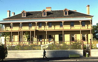
The Paddington Reservoir is a heritage-listed public park located at 255a Oxford Street in the inner eastern Sydney suburb of Paddington. It was designed by Edward Bell and built from 1864 to 1866 and operated as a water reservoir which accepted water from the Botany Swamps pumping station for supply to parts of Sydney between 1866 and 1899. In the twentieth century the site variously functioned as a service station and storage and mechanical workshop site. In 2006 work commenced to convert the site into a sunken garden and park. It is also known as Walter Read Reserve; Paddington Reservoir Gardens; Reservoir Gardens. The property is owned by City of Sydney. It was added to the New South Wales State Heritage Register on 2 April 1999.

<span class="mw-page-title-main">Juniper Hall, Paddington</span> Building in Australia

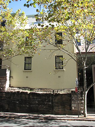
Juniper Hall, also known as Ormond House, is a heritage-listed former residence and children's home and now retail building and exhibition venue located at 1 Ormond Street, Paddington, Sydney, New South Wales, Australia. It was built from 1824 to 1825 by Robert Cooper. The two-storey Old Colonial Georgian house was added to the New South Wales State Heritage Register on 2 April 1999 and is listed on the Register of the National Estate

<span class="mw-page-title-main">Newcastle City Hall (Australia)</span> City hall in New South Wales, Australia

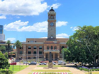
The Newcastle City Hall is a heritage-listed building located in the regional New South Wales city of Newcastle in the Hunter region in Australia. The building served as the city hall for the Council of the City of Newcastle between 1929 and 1977.

<span class="mw-page-title-main">Erskineville Town Hall</span> Government town hall in New South Wales, Australia

The Erskineville Town Hall is a landmark civic building in Erskineville, a suburb of Sydney. It stands at 104 Erskineville Road. It was opened in 1938 in the Inter-war Mediterranean style by Lindsay Gordon Scott. The Town Hall was the seat of Erskineville Municipal Council from 1938 to 1948 and was the seat of the South Sydney Councils from 1968 to 1982 and 1989 to 2003. Since 2004 the town hall has been a community centre for the City of Sydney servicing the local area and is listed as a heritage item of local significance by the City of Sydney.

<span class="mw-page-title-main">Glebe Town Hall</span> Government town hall in New South Wales, Australia

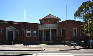
The Glebe Town Hall is a landmark civic building in Glebe, a suburb of Sydney, Australia. It stands at 160 St Johns Road and was built in 1880 in the Victorian Italianate style by architect Ambrose Thornley. The Town Hall was the seat of The Glebe Municipal Council from 1880 to 1948 when it became a community centre and hall run by the City of Sydney. After being transferred to the Municipality of Leichhardt in 1968, it was returned to the control of the City of Sydney following a boundary change on 8 May 2003.

<span class="mw-page-title-main">Municipality of Paddington</span> Former local government area in New South Wales, Australia

The Municipality of Paddington was a local government area of Sydney, New South Wales, Australia. The municipality was proclaimed on 17 April 1860 and, with an area of 1.7 square kilometres, included the entire suburb of Paddington and parts of Edgecliff. The council was amalgamated with the City of Sydney to the east with the passing of the Local Government (Areas) Act 1948, although the former council area was transferred in 1968 to the Municipality of Woollahra, transferred to the City of South Sydney in 1989 and was then split in 2003 between the City of Sydney and the Municipality of Woollahra.

<span class="mw-page-title-main">Petersham Town Hall</span> Town hall in Australia

The Petersham Town Hall is a heritage-listed town hall located at 107 Crystal Street in Petersham, a suburb in the Inner West of Sydney, Australia. It was built in 1937–38 in the Inter-War Stripped Classical architectural style by architects Rudder & Grout, and replaced the first Petersham Town Hall on the site, which was designed in the Victorian_Renaissance_Revival style by Thomas Rowe in 1880–1882. The Town Hall was the seat of Petersham Municipal Council from 1938 to 1948 and from 1948 to 1974 was the seat of the Municipality of Marrickville, which absorbed Petersham. When the council moved to new offices across the street in 1974, the town hall has primarily been used as a meeting hall, community centre, filming location and archival office.

<span class="mw-page-title-main">Paddington Post Office</span> Post office in Sydney, Australia

The Paddington Post Office is a heritage-listed post office located at 246 Oxford Street in Paddington, a suburb of Sydney, Australia. The post office is owned and operated by Australia Post. The building was also a former telephone exchange. It was designed by the New South Wales Colonial Architect's Office under James Barnet and later Walter Liberty Vernon, and was built by William Farley. The building was added to the Commonwealth Heritage List, the New South Wales State Heritage Register on 22 December 2000, and the Register of the National Estate.

<span class="mw-page-title-main">Wentworth Memorial Church</span> Church in New South Wales, Australia

Wentworth Memorial Church is a heritage-listed former Anglican church building located at 32B Fitzwilliam Road, Vaucluse in the Municipality of Woollahra local government area of New South Wales, Australia. It was designed by Clarke Gazzard and Partners and built by Monteith Constructions, with Miller Milston and Ferris as engineers. The property is privately owned; and was formerly owned by the Anglican Diocese of Sydney. It was added to the New South Wales State Heritage Register on 25 September 2012.

<span class="mw-page-title-main">North Sydney Post Office</span> Historic site in New South Wales, Australia

The North Sydney Post Office is a heritage-listed post office located at 92-94 Pacific Highway, North Sydney, North Sydney Council, New South Wales, Australia. It was designed by the Colonial Architect’s Office under the direction of James Barnet, and built from 1885 to 1889 by James Reynolds. The property is owned by Australia Post, an agency of the Australian Government. It was added to the New South Wales State Heritage Register on 22 December 2000.

<span class="mw-page-title-main">Canterbury Town Hall</span> Government town hall in New South Wales, Australia

The Canterbury Town Hall was an Australian municipal town hall located at 322 Canterbury Road in Canterbury, a suburb in the Inner West of Sydney, New South Wales. It was built in 1889 in the Victorian Free Classical architectural style by architect W. H. Monckton, and was officially opened on 11 April 1889 by the Prime Minister of New South Wales, Sir Henry Parkes. The Town Hall was the seat of Canterbury Municipal Council from 1889 to 1963. When the council moved to a new purpose-built administration centre on Beamish Street in Campsie, a recognition of the change in economic importance of Campsie, the town hall was quickly disposed of by Council and demolished, being replaced by a service station. Today the Town Hall site is part derelict and part paint shop.

<span class="mw-page-title-main">Randwick Presbyterian Church</span> Church in New South Wales, Australia

The Randwick Presbyterian Church is a heritage-listed Presbyterian church building located at 162 Alison Road in the Sydney suburb of Randwick in the City of Randwick local government area of New South Wales, Australia. The church was designed by Sir John Sulman and built from 1889 to 1890 by George Gale. The property is owned by the Randwick Presbyterian Church and was added to the New South Wales State Heritage Register on 8 May 2008.

<span class="mw-page-title-main">71 Harrington Street, The Rocks</span> Building in suburban Sydney, Australia

71 Harrington Street, The Rocks are heritage-listed serviced apartments and former terrace houses and shops located at 71 Harrington Street, in the inner city Sydney suburb of The Rocks in the City of Sydney local government area of New South Wales, Australia. It was built from 1860. It is also known as Sailors Return Hotel; Stafford Apts. and 75 Harrington Street; Clocktower Development. The property is owned by Property NSW, an agency of the Government of New South Wales. It was added to the New South Wales State Heritage Register on 10 May 2002.

References

  1. Gazzard, Don (October 2012). "Heritage in action…". Architect and Writer: Don Gazzard. Retrieved 28 May 2017.
  2. 1 2 3 4 5 6 7 8 9 10 11 12 13 14 15 16 17 18 19 20 21 22 23 24 25 26 27 28 29 30 31 32 "Paddington Town Hall". New South Wales State Heritage Register . Department of Planning & Environment. H00561. Retrieved 13 October 2018. CC BY icon.svg Text is licensed by State of New South Wales (Department of Planning and Environment) under CC-BY 4.0 licence .
  3. Pollen, 1988, 195-7
  4. "THE PADDINGTON TOWN HALL". The Sydney Morning Herald. No. 16, 703. New South Wales, Australia. 5 October 1891. p. 9. Retrieved 28 May 2017 via National Library of Australia.
  5. "ILLUSTRATIONS". The Sydney Mail and New South Wales Advertiser . Vol. LII, no. 1631. New South Wales, Australia. 10 October 1891. p. 808. Retrieved 28 May 2017 via National Library of Australia.
  6. Donovan, Barry (5 September 2009). "Hawke and the new unionism". The Sydney Morning Herald. Retrieved 28 May 2017.
  7. "Unions not satisfied by offer". The Canberra Times . Vol. 44, no. 12, 410. Australian Capital Territory, Australia. 8 September 1969. p. 1. Retrieved 28 May 2017 via National Library of Australia.
  8. "Chauvel Cinema". Palace Cinemas. Palace Films and Cinemas. Retrieved 1 April 2015.
  9. Apperly, Irving & Reynolds 1989: 56-59
  10. National Estate Register
  11. "PADDINGTON CORONATION PROPOSAL". The Sydney Morning Herald. No. 20, 077. New South Wales, Australia. 16 July 1902. p. 5. Retrieved 28 May 2017 via National Library of Australia.
  12. "PADDINGTON TOWN HALL". The Sydney Morning Herald. No. 20, 956. New South Wales, Australia. 6 May 1905. p. 9. Retrieved 28 May 2017 via National Library of Australia.
  13. "TOWN CLOCK AT PADDINGTON". The Sydney Morning Herald. No. 21, 056. New South Wales, Australia. 31 August 1905. p. 3. Retrieved 28 May 2017 via National Library of Australia.

Bibliography

Attribution

CC BY icon-80x15.png This Wikipedia article contains material from Paddington Town Hall , entry number 561 in the New South Wales State Heritage Register published by the State of New South Wales (Department of Planning and Environment) 2018 under CC-BY 4.0 licence , accessed on 13 October 2018.