
Columbus is the capital and most populous city of the U.S. state of Ohio. With a 2020 census population of 905,748, it is the 14th-most populous city in the U.S., the second-most populous city in the Midwest after Chicago, and the third-most populous U.S. state capital after Phoenix, Arizona and Austin, Texas. Columbus is the county seat of Franklin County; it also extends into Delaware and Fairfield counties. It is the core city of the Columbus metropolitan area, which encompasses ten counties in central Ohio. It had a population of 2,138,926 in 2020, making it the largest metropolitan area entirely in Ohio and 32nd-largest metro area in the U.S.

Dayton is a city in and the county seat of Montgomery County, Ohio, United States. A small part of the city extends into Greene County. As of the 2020 census, the city proper had a population of 137,644, making it the sixth-most populous city in Ohio. Dayton anchors the state's fourth-largest metropolitan area, the Dayton metropolitan area, which had 814,049 residents. Dayton is located within Ohio's Miami Valley region, 50 miles (80 km) north of Cincinnati and 60 miles (97 km) west of Columbus. It is a principal city of the Dayton–Springfield–Sidney combined statistical area, home to a population of 1,086,512.

The Ohio State University is a public land-grant research university in Columbus, Ohio. A member of the University System of Ohio, it was founded in 1870. The university consists of sixteen colleges and offers over 400 degree programs at the undergraduate and graduate levels. The main campus has grown into the fifth-largest university campus by enrollment in the United States, with nearly 50,000 undergraduate students and nearly 15,000 graduate students. The university also operates regional campuses in Lima, Mansfield, Marion, Newark, and Wooster.

Athens is a city and the county seat of Athens County, Ohio, United States. The population was 23,849 at the 2020 census. Located along the Hocking River within Appalachian Ohio about 65 miles (105 km) southeast of Columbus, Athens is best known as the home of Ohio University, a large public research university with an undergraduate and graduate enrollment of more than 21,000 students. It is the principal city of the Athens micropolitan area.

Cuyahoga County is a large urban county located in the northeastern part of the U.S. state of Ohio. The county seat and largest city is Cleveland. As of the 2020 census, its population was 1,264,817, making it the second-most populous county in the state.

Steubenville is a city in and the county seat of Jefferson County, Ohio, United States. Located along the Ohio River 33 miles (53 km) west of Pittsburgh, it had a population of 18,161 at the 2020 census. The city's name is derived from Fort Steuben, a 1786 fort that sat within the city's current limits and was named for Prussian military officer Baron Friedrich Wilhelm von Steuben. It is a principal city of the Weirton–Steubenville metropolitan area, which had a 2020 population of 116,903 residents.

Portsmouth is a city in and the county seat of Scioto County, Ohio, United States. Located in southern Ohio 41 miles (66 km) south of Chillicothe, it lies on the north bank of the Ohio River, across from Kentucky, just east of the mouth of the Scioto River. The population was 18,252 at the 2020 census. It is the principal city of the Portsmouth micropolitan area.

Youngstown is a city in and county seat of Mahoning County, Ohio, United States. At the 2020 census, it had a population of 60,068, making it the 11th-most populous city in Ohio. It is a principal city of the Youngstown–Warren metropolitan area, which had a population of 430,591 in 2020, making it the seventh-largest metro area in Ohio and 125th-largest metro area in the U.S. Youngstown is situated on the Mahoning River in Northeast Ohio, 58 miles (93 km) southeast of Cleveland and 61 miles (100 km) northwest of Pittsburgh.

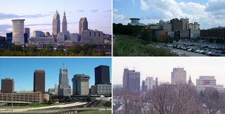
The Cleveland metropolitan area, or Greater Cleveland as it is more commonly known, is the metropolitan area surrounding the city of Cleveland in Northeast Ohio, United States. According to the 2020 census results, the six-county Cleveland, OH Metropolitan Statistical Area (MSA) consists of Cuyahoga County, Ashtabula County, Geauga County, Lake County, Lorain County, and Medina County, and has a population of 2,185,825, making it the 33rd-most populous metropolitan area in the United States and the third largest metropolitan area in Ohio. The metro area is also part of the larger Cleveland–Akron–Canton Combined Statistical Area with a population of over 3.7 million people, the most populous statistical area in Ohio and the 17th most populous in the United States.
The region Northeast Ohio, in the US state of Ohio, in its most expansive usage contains six metropolitan statistical areas: Cleveland–Elyria, Akron, Canton–Massillon, Youngstown–Warren, Mansfield, and Weirton–Steubenville along with eight micropolitan statistical areas. Most of the region is considered either part of the Cleveland–Akron–Canton, OH Combined Statistical Area and media market or the Youngstown–Warren, OH–PA Combined Statistical Area and media market. In all, the region is home to: 4,502,460 residents. It is also a part of the Great Lakes megalopolis, containing over 54 million people. Northeast Ohio also includes most of the area known historically as the Connecticut Western Reserve.

Owens Community College (OCC) is a public community college with campuses in Toledo and Findlay, Ohio. Owens was founded in 1965 in Toledo and chartered in 1967. The Findlay campus opened in 1983. Owens Community College is named after Michael J. Owens, the Toledo-based inventor of automated glass bottle-making technology.

State Route 13 is a north–south state highway in the northern and southeastern portion of the U.S. state of Ohio. It is the tenth longest state route in Ohio. Its southern terminus is at State Route 550 near Athens, and its northern terminus is at U.S. Route 6 in Huron.

The Youngstown–Warren, OH Metropolitan Statistical Area, typically known as the Mahoning Valley, is a metropolitan area in Northeast Ohio with Youngstown, Ohio, at its center. According to the U.S. Census Bureau, the metropolitan statistical area (MSA) includes Mahoning and Trumbull counties. As of the 2020 census, the region had a population of 430,591, making it the 125th-largest metro area in the country.
The Huntington–Ashland metropolitan area is a metropolitan area in the Appalachian Plateau region of the United States. Referred to locally as the "Tri-State area," and colloquially as "Kyova", the region spans seven counties in the three states of Kentucky, Ohio, and West Virginia. With a population of 361,580, the Tri-State area is nestled along the banks of the Ohio River. The region offers a diverse range of outdoor activities.
The University System of Ohio is the public university system of the U.S. state of Ohio. It is governed by the Ohio Department of Higher Education.

The Cincinnati metropolitan area is a metropolitan area with its core in Ohio and Kentucky. Its largest city is Cincinnati and includes surrounding counties in the U.S. states of Ohio, Kentucky, and Indiana.

The Kidwell Covered Bridge, in Dover Township, Athens County, Ohio between the nearby hamlets of Truetown and Redtown, was built in 1880. It spans Sunday Creek. It was listed on the National Register of Historic Places in 1977.
Redtown is an unincorporated community in Angelina County, in the U.S. state of Texas. According to the Handbook of Texas, the community had a population of 50 in 2000. It is located within the Lufkin, Texas micropolitan area.

