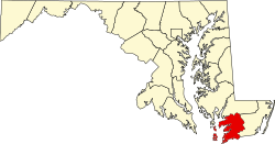
Rehobeth, Maryland | |
---|---|
Unincorporated community | |
Coventry Parish ruins | |
Coordinates: 38°02′20″N75°39′47″W / 38.03889°N 75.66306°W Coordinates: 38°02′20″N75°39′47″W / 38.03889°N 75.66306°W | |
Country | |
State | |
County | |
Elevation | 3 m (10 ft) |
Time zone | Eastern (EST) (UTC-5) |
• Summer (DST) | EDT (UTC-4) |
ZIP code | 21857 |
Area code(s) | 410, 443, and 667 |
GNIS feature ID | 591110 [1] |
Rehobeth is an unincorporated community in Somerset County, Maryland, United States. [1] It is located at the east end of Old Rehobeth Road, off Rehobeth Road, on the bank of the Pocomoke River. Caldicott, Coventry Parish Ruins, and Rehobeth Presbyterian Church are listed on the National Register of Historic Places. [2]
In law, an unincorporated area is a region of land that is not governed by a local municipal corporation; similarly an unincorporated community is a settlement that is not governed by its own local municipal corporation, but rather is administered as part of larger administrative divisions, such as a township, parish, borough, county, city, canton, state, province or country. Occasionally, municipalities dissolve or disincorporate, which may happen if they become fiscally insolvent, and services become the responsibility of a higher administration. Widespread unincorporated communities and areas are a distinguishing feature of the United States and Canada. In most other countries of the world, there are either no unincorporated areas at all, or these are very rare; typically remote, outlying, sparsely populated or uninhabited areas.
Somerset County is the southernmost county in the U.S. state of Maryland. As of the 2010 census, the population was 26,470. making it the second-least populous county in Maryland. The county seat is Princess Anne.
Maryland is a state in the Mid-Atlantic region of the United States, bordering Virginia, West Virginia, and the District of Columbia to its south and west; Pennsylvania to its north; and Delaware to its east. The state's largest city is Baltimore, and its capital is Annapolis. Among its occasional nicknames are Old Line State, the Free State, and the Chesapeake Bay State. It is named after the English queen Henrietta Maria, known in England as Queen Mary.
The community was named after Rehoboth, a place mentioned in the Hebrew Bible, via a local plantation of that name. [3]
Rehoboth is the name of three biblical places:
Boggs Township is a township in Armstrong County, Pennsylvania, United States. The population was 936 at the 2010 census.
White Plains is an unincorporated community located in Charles County, Maryland, in the United States, just south of Waldorf. It is located at latitude 38°35'25" North; longitude 76°56'26" West. The United States Postal Service has assigned White Plains the ZIP Code 20695. While the commercial portion of White Plains lies along U.S. Route 301, the largest concentration of residences with the White Plains mailing address is actually six to seven miles to the west in developments located near Billingsley Road. The area is experiencing population sprawl from the adjacent unincorporated communities of Waldorf and St. Charles, features new office parks and a scenic new rail trail. The Charles County Department of Health is headquartered in White Plains, and a public golf course is also located there. Plans to complete an east-west connector road in the area were mired in controversy because of alleged adverse effects on the environment.
Montchanin is an unincorporated community in New Castle County, Delaware, United States. Montchanin is located at the intersection of Delaware Route 100 and Kirk Road to the northwest of Wilmington.
Boone Township is one of 12 townships in Harrison County, Indiana, United States. As of the 2010 census, its population was 1,391 and it contained 628 housing units.
Talleyville is an unincorporated community in New Castle County, Delaware, United States. Talleyville is located at the intersection of U.S. Route 202, Mt. Lebanon Road, and Silverside Road to the north of Wilmington. Its ZIP code is 19803.
Rockland is an unincorporated community in northern New Castle County, Delaware, United States. It lies along Rockland Road north of the city of Wilmington, the county seat of New Castle County. Its elevation is 194 feet (59 m). Although it is unincorporated, it has a post office, with the ZIP code of 19732. The Rockland Historic District and William Young House are listed on the National Register of Historic Places.
Batesville is an unincorporated community in Albemarle County, Virginia, United States. Its elevation is 620 feet (190 m).
Omar is an unincorporated community in Sussex County, Delaware, United States, located at the crossroads of Delaware Route 20 and Sussex County Road 54 and between the towns of Dagsboro and Roxana.
Caldicott, also known as Vessey House and Essex Farm, is a historic home located at Rehobeth, Somerset County, Maryland, United States. It is a large frame dwelling constructed between 1784 and 1798. The house stands two stories above a raised basement of Flemish bond brick. Also on the property are a gambrel-roofed barn, sheds and storage buildings, and a water tower.
Shelltown is an unincorporated community in Somerset County, Maryland, United States. It is near the mouth of the Pocomoke River and takes its name from the abundant number of oysters, crabs, and other assorted crustaceans in the area.
Kingston is an unincorporated community in Somerset County, Maryland, United States. A small community at the head of navigation of the Big Annemessex River, it is located on Maryland Route 413 at the intersection of Kingston Lane. A very rural community far from any urban development, it is quite small in population, the land dominated by agricultural fields and tree farms.
Wittman is an unincorporated community in Talbot County, Maryland, United States. Wittman is located at the intersection of Pot Pie Road, New Road, and Cummings Road south of Claiborne. Although it is unincorporated, it has a post office, with the ZIP code of 21676. The Flying Cloud was listed on the National Register of Historic Places in 1985.
Jerusalem is an unincorporated community in Harford County, Maryland, United States. It is the location of the historic Jerusalem Mill Village and Jericho Covered Bridge, both listed on the National Register of Historic Places. Jerusalem Mill Village is located on Jerusalem Road in Kingsville, MD between the Little Gunpowder Falls river and Jericho Road.
Ashland is an unincorporated community in New Castle County, Delaware, United States. Ashland is located at the intersection of Delaware Route 82 and Barley Mill Road along the Red Clay Creek.
Mount Cuba is an unincorporated community in New Castle County, Delaware, United States. Mount Cuba is located at the intersection of Delaware Route 82 and Mount Cuba Road along the east bank of the Red Clay Creek. The Mount Cuba Historic District was listed on the National Register of Historic Places in 1979.
Wooddale is an unincorporated community in New Castle County, Delaware, United States. Wooddale is located along the Red Clay Creek and West Rolling Mill Road west of Wilmington. The Wooddale Historic District and Wooddale Bridge are listed on the National Register of Historic Places.
Mastens Corner is an unincorporated community in Kent County, Delaware, United States. Mastens Corner is located at the intersection of Hopkins Cemetery Road and Hills Market Road 3.8 miles (6.1 km) northwest of Harrington.
Rosemont is an unincorporated community located within Delaware Township in Hunterdon County, New Jersey, United States. Its ZIP code is 08556. Located at the top of a small hill, the center of the community is located along Kingwood Stockton Road near its intersections with Raven Rock Rosemont Road and Rosemont Ringoes Road. Farmland and residences make up the surrounding area while the center of the settlement includes residences, a post office, and an antique shop.
Sherman is an unincorporated community in Grant County, New Mexico, United States. Sherman is located on New Mexico State Road 61 23 miles (37 km) east of Silver City.
Harbourton is a historic unincorporated community located within Hopewell Township in Mercer County, New Jersey, United States. It is located along County Route 579 at the intersection with Harbourton-Mount Airy Road. The community was added to the National Register of Historic Places in 1974.
This article about a location in Somerset County Maryland is a stub. You can help Wikipedia by expanding it. |