Reklamasi Pusong Beach is in the northern city of Aceh province, namely Lhokseumawe.
Pusong Island is a small island, surrounded by coral reefs and a landmass which includes poor soil.[citation needed] Expanses of coral, two times larger than the size of the island itself, is visible at low tide.[citation needed] There are about 8000 residents on the island, which has an area of no more than 6acres.[citation needed]
Actually, the island is quite widely used, but due to the abrasion of sea water, and frequent dredging sand for sale, causing Pusong island beach and also this is not an area of the size used, while still natural. The beach is located on the island of Pusong this is called Reklamasi Pusong Beach.[clarification needed]
Papua is the largest and easternmost province of Indonesia, comprising most of Western New Guinea. It is bordered by the state of Papua New Guinea to the east, the province of West Papua to the west, the Pacific Ocean to the north, and the Arafura Sea to the south. According to the 2010 census by Statistics Indonesia, Papua had a population of 2,833,381, the majority of whom are Christians. The 2015 Intermediate Census revealed a population of 3,143,088, while the latest official estimate is 3,347,100. The province is divided into twenty-eight regencies and one city. Its capital and largest city is Jayapura.
Timor is an island at the southern end of Maritime Southeast Asia, north of the Timor Sea. The island is divided between the sovereign states of East Timor on the eastern part and Indonesia on the western part. The Indonesian part, also known as West Timor, constitutes part of the province of East Nusa Tenggara. Within West Timor lies an exclave of East Timor called Oecusse District. The island covers an area of 30,777 square kilometres. The name is a variant of timur, Malay for "east"; it is so called because it lies at the eastern end of the Lesser Sunda Islands. Mainland Australia is less than 500 km away, separated by the mentioned Timor Sea.
Balikpapan is a seaport city in East Kalimantan, Indonesia. Located on the east coast of the island of Borneo (Kalimantan), the city is the financial centre of Kalimantan and the main gateway to the new capital of Indonesia. Balikpapan is the city with the largest economy in Kalimantan with an estimated 2016 GDP at Rp 73.18 trillion. The city has both the busiest airport and seaport in Kalimantan, namely Sultan Aji Muhammad Sulaiman Sepinggan Airport and Port of Semayang. With a population of 645,727 as of 2018, Balikpapan is the second most populous city in East Kalimantan, after Samarinda. Balikpapan has been consistently ranked as one of the most liveable cities in Indonesia.
Biak is a small island located in Cenderawasih Bay near the northern coast of Papua, an Indonesian province, and is just northwest of New Guinea. Biak is the largest island in its small archipelago, and has many atolls, reefs, and corals.
Padang is the capital and largest city of the Indonesian province of West Sumatra. With an estimated population of 939,112 as of 2018, it is the 16th most populous city in Indonesia and the most populous city on the west coast of Sumatra. The Padang metropolitan area is the third most populous metropolitan area in Sumatra with a population of over 1.4 million. Padang is widely known for its Minangkabau culture, cuisine, and sunset beaches.
Banjarmasin is the capital of South Kalimantan, Indonesia. It is located on a delta island near the junction of the Barito and Martapura rivers. As a result, Banjarmasin is sometimes called the "River City". Its population was 625,395 at the 2010 Census and estimated to be more than 720,000 in late 2018.
The Tunku Abdul Rahman National Park comprises a group of 5 islands located between 3 and 8 km off Kota Kinabalu in Sabah, Malaysia. The park is spread over 4,929 hectares, two-thirds of which cover the sea. Before the Ice age, it formed part of the Crocker Range mass of sandstone and sedimentary rock on the mainland. However, about one million years ago, the melting ice brought about changes in the sea level and parts of the mainland were cut off by the sea to form the islands of Gaya, Sapi, Manukan, Mamutik and Sulug. Evidence of this can be seen from the exposed sandstone of the coastline forming the cliffs, caves, honeycombs and deep crevices. The park was named after Tunku Abdul Rahman, Malaysia's first Prime Minister.
Gaya Island is a sizeable Malaysian island of 1,465 ha, just 10 minutes off Kota Kinabalu, Sabah and forms part of the Tunku Abdul Rahman National Park. Gaya Island derived its name from the Bajau word "Gayo" which means big and occupies an area of 15 km² with an elevation of up to 300 metres. Several ridges rise more than 600 feet, peaking at 1,000 feet, along the backbone of Gaya Island.
Trenggalek is a regency (kabupaten) in East Java, Indonesia. The central government is located in Trenggalek Kota, which literally means "Trenggalek City".
Gorontalo is a city and the capital of the Gorontalo Province, Indonesia. It is on the island of Sulawesi. The city has an area of 64.79 km² and a population of 179,991 at the 2010 Census.
Weh Island, often known as Sabang after the largest city, is a small active volcanic island to the northwest of Sumatra, 45 minutes by fast regular ship or 2 hours by ferry from mainland, Banda Aceh. It was originally connected to the Sumatran mainland and became separated by sea after the volcano's last eruption in the Pleistocene era. The island is situated in the Andaman Sea. The largest city on the island, Sabang, is the northernmost outpost of Indonesia.
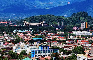
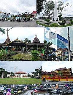
Lhokseumawe, is the second largest city in Aceh Special District, in the north of Sumatra, Indonesia. The city covers an area of 181.06 square kilometres, and had a population of 171,163 at the 2010 Census; the latest official estimate is 180,200. Being between Banda Aceh and the large southern city of Medan, the town is a key regional centre important for the economy of Aceh.
North Aceh Regency is a regency in Nanggroe Aceh Darussalam, in Indonesia. It is located on the island of Sumatra. The regency covers an area of 3,236.86 square kilometres and according to the 2010 census had a population of 529,751; the latest official estimate is 602.554. This follows the separation in 2001 of the former capital of Lhokseumawe, which was cut out of the regency to form an independent city.
Raja Ampat is located off the northwest tip of Bird's Head Peninsula on the island of New Guinea, in Indonesia's West Papua province, Raja Ampat, or the Four Kings, is an archipelago comprising over 1,500 small islands, cays, and shoals surrounding the four main islands of Misool, Salawati, Batanta, and Waigeo, and the smaller island of Kofiau.
Nembrala is a beach on Rote Island, East Nusa Tenggara, Indonesia. The beach is well known for surfing.
Ujung Blang beach is one of a famous beach in Lhokseumawe. Ujung Blang beach stretch of the river estuary Cunda covering four region namely Ujung Blang village, Ulee Jalan village, Hagu Barat Laut village, and Hagu Tengah village.
Seumadu Island is located in Muara Satu, about 10 kilometers east of Lhokseumawe. This island is a tourist spot for the citizens of Lhokseumawe for whom it is easily accessible. The island is also commonly known as Rancong Beach.
Krueng Cunda River is a river in Aceh on Sumatra island, in Indonesia, about 1700 km northwest of the capital Jakarta. It forms a strait separating the main part of Lhokseumawe from the island of Sumatra.
This page is based on this Wikipedia article Text is available under the CC BY-SA 4.0 license; additional terms may apply. Images, videos and audio are available under their respective licenses.