Langsa

Last updated
Langsa
City of Langsa
Kota Langsa
Other transcription(s)
   Jawi لڠسا
Langsa Bale Juang.jpg
Bale Juang Museum in Langsa
Flag of Langsa City.png
Pemko langsa.jpg
Motto(s): 
Indonesian: Terwujudnya Masyarakat yang Aman, Damai, Bermartabat, Maju, Sejahtera, dan Islami
English: Realization of a Safe Community, Peace, Dignity, Progress, Prosperity with islamic values
Lokasi Aceh Kota Langsa.svg
Location within Aceh
Indonesia Aceh location map.svg
Red pog.svg
Langsa
Location in Aceh, Northern Sumatra, Sumatra and Indonesia
Location map Northern Sumatra.png
Red pog.svg
Langsa
Langsa (Northern Sumatra)
Indonesia Sumatra location map.svg
Red pog.svg
Langsa
Langsa (Sumatra)
Indonesia location map.svg
Red pog.svg
Langsa
Langsa (Indonesia)
Coordinates: 4°28′48″N97°57′48″E / 4.48000°N 97.96333°E / 4.48000; 97.96333
Country Flag of Indonesia.svg  Indonesia
Region Sumatra
Province Flag of Aceh, Indonesia.svg  Aceh
City Established17 October 2001
Government
  Mayor Jeffry Sentana Putra  [ id ]
  Vice Mayor Muhammad Haikal Alfisyahrin  [ id ]
Area
  Total
239.83 km2 (92.60 sq mi)
Population
 (mid 2023 estimate)
  Total
186,958
  Density780/km2 (2,000/sq mi)
  [1]
Time zone UTC+7 (IWST)
Area code (+62) 641
Website langsakota.go.id

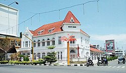
Langsa (Indonesian: Kota Langsa, Jawi: لڠسا), is a city in Aceh, Indonesia. It is located on the island of Sumatra. Apart from a small seacoast to the northeast, it borders Manyak Payed District of Aceh Tamiang Regency to the east and is otherwise surrounded by Birem Bayeun District of Aceh Timur Regency (of which the city was formerly a part until 2001) to the north, west and south. The city covers an area of 239.83 square kilometres and had a population of 148,945 at the 2010 Census [2] (compared with 117,256 at the previous 2000 Census); this grew to 185,971 at the 2020 Census, [3] and the official estimate as at mid 2023 was 186,958. [1]

Contents

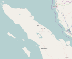
Langsa is located 440 kilometres (273 miles) from the city of Banda Aceh, the province's capital. Langsa is close to its province's southern border and is 167 kilometres (103 miles) from Medan, the capital city of North Sumatra. This makes Langsa a strategic city for trade and traffic between the two provinces. [4]

There are several universities in the city of Langsa both state and private universities. Among them are Samudra University and IAIN Zawiyah Cot Kala, Campus LP3I. The city hosts several schools of nursing and midwifery, including the Academy of Nursing of "Harapan Ibu", the Academy of Nursing "Yayasan Cut Nyak Dhien" and the Academy of Nursing "UMMI".

History

Darul Islam Rebellion

On 21 September 1953, Darul Islam forces invaded Langsa. They attacked Military Police and the Mobile Brigade barracks. The Indonesian National Armed Forces repelled this Darul Islam attack after receiving reinforcement troops from Medan. [5]

Administrative districts

The city is divided into five districts (kecamatan), tabulated below with areas and their population at the 2010 [2] and 2020 [3] Censuses, together with the official estimates as at mid 2023. [1] The table also includes the locations of the district administrative centres, the number of administrative villages in each village (urban gampong), and its postal codes.

Kode
Wilayah
Name of
District
(kecamatan)
Area
in
km2
Pop'n
Census
2010
Pop'n
Census
2020
Pop'n
Estimate
mid 2023
Admin
centre
No.
of
villages
Post
codes
11.74.01 Langsa Timur [6]
(East Langsa)
78.2313,81816,62717,561Seunebuk Antara1624411
11.74.04Langsa Lama [7] 45.0526,87733,23133,690Meurandeh1524411 & 24416
11.74.02Langsa Barat [8]
(West Langsa)
48.7830,58339,55339,470Matang Seulimeng1324410, 24413,
24414 & 24415
11.74.05Langsa Baro [9] 61.6841,80455,82456,560Geudubang Aceh1224415
11.73.03Langsa Kota [10]
(Langsa Town)
6.0935,86340,73639,677Gampong Teungoh1024410, 24412,
24414 & 24416
Totals239.83148,945185,971186,95866

Note that the most westerly district of Langsa is Langsa Baro District, while Langsa Barat District is actually the most northerly, and Langsa Lama District lies to the south of Langsa Kota (Langsa Town).

Climate

Langsa has a tropical rainforest climate (Af) with moderate rainfall from February to April and heavy rainfall in the remaining months.

Climate data for Langsa
MonthJanFebMarAprMayJunJulAugSepOctNovDecYear
Mean daily maximum °C (°F)31.0
(87.8)
32.0
(89.6)
32.4
(90.3)
32.5
(90.5)
32.5
(90.5)
32.4
(90.3)
32.1
(89.8)
32.0
(89.6)
31.3
(88.3)
31.1
(88.0)
30.6
(87.1)
30.7
(87.3)
31.7
(89.1)
Daily mean °C (°F)26.6
(79.9)
27.1
(80.8)
27.4
(81.3)
27.7
(81.9)
27.8
(82.0)
27.6
(81.7)
27.2
(81.0)
27.2
(81.0)
26.9
(80.4)
26.9
(80.4)
26.5
(79.7)
26.6
(79.9)
27.1
(80.8)
Mean daily minimum °C (°F)22.2
(72.0)
22.2
(72.0)
22.4
(72.3)
23.0
(73.4)
23.1
(73.6)
22.8
(73.0)
22.3
(72.1)
22.4
(72.3)
22.6
(72.7)
22.8
(73.0)
22.5
(72.5)
22.5
(72.5)
22.6
(72.6)
Average rainfall mm (inches)149
(5.9)
83
(3.3)
85
(3.3)
94
(3.7)
179
(7.0)
140
(5.5)
160
(6.3)
200
(7.9)
233
(9.2)
242
(9.5)
237
(9.3)
275
(10.8)
2,077
(81.7)
Source: Climate-Data.org [11]

Population

Acehnese speakers.

Langsa's population is mainly made up of people of Acehnese, Malay, Javanese, Chinese, and Batak ethnicities. Acehnese is the main language used by people who consider themselves as of Acehnese ethnicity, but the Indonesian language is the official language.

Islam is the religion of the majority in Aceh, including Langsa, but other religions exist, such as Christianity and Buddhism. Buddhism is common among Langsa's ethnically Chinese population.

People from Langsa

References

  1. 1 2 3 Badan Pusat Statistik, Jakarta, 26 September 2024, Kota Langsa Dalam Angka 2024 (sum of returns from District Katalogs as referenced below)
  2. 1 2 Biro Pusat Statistik, Jakarta, 2011.
  3. 1 2 Badan Pusat Statistik, Jakarta, 2021.
  4. "Langsa profile in Kemendagri.go.id". Archived from the original on 2018-01-15. Retrieved 2016-08-09.
  5. van Dijk, Cornelis (1981). Rebellion under the Banner of Islam: The Darul Islam in Indonesia. The Hague: Martinus Nijhoff. p. 307.
  6. Badan Pusat Statistik, Jakarta, 26 September 2024, Kecamatan Langsa Timur Dalam Angka 2024 (Katalog-BPS 1102001.1173010).
  7. Badan Pusat Statistik, Jakarta, 26 September 2024, Kecamatan Langsa Lama Dalam Angka 2024 (Katalog-BPS 1102001.1173011).
  8. Badan Pusat Statistik, Jakarta, 26 September 2024, Kecamatan Langsa Barat Dalam Angka 2024 (Katalog-BPS 1102001.1173020).
  9. Badan Pusat Statistik, Jakarta, 26 September 2024, Kecamatan Langsa Baro Dalam Angka 2024 (Katalog-BPS 1102001.1173021).
  10. Badan Pusat Statistik, Jakarta, 26 September 2024, Kecamatan Langsa Kota Dalam Angka 2024 (Katalog-BPS 1102001.1173030).
  11. "Climate: Langsa". Climate-Data.org. Archived from the original on 15 September 2023. Retrieved 5 November 2020.