
The candela is the unit of luminous intensity in the International System of Units (SI). It measures luminous power per unit solid angle emitted by a light source in a particular direction. Luminous intensity is analogous to radiant intensity, but instead of simply adding up the contributions of every wavelength of light in the source's spectrum, the contribution of each wavelength is weighted by the luminosity function, the model of the sensitivity of the human eye to different wavelengths, standardized by the CIE and ISO. A common wax candle emits light with a luminous intensity of roughly one candela. If emission in some directions is blocked by an opaque barrier, the emission would still be approximately one candela in the directions that are not obscured.
Socastee is a census-designated place (CDP) in Horry County, South Carolina, United States. The population was 19,952 at the 2010 census.

The Mid-Atlantic Ridge is a mid-ocean ridge located along the floor of the Atlantic Ocean, and part of the longest mountain range in the world. In the North Atlantic, the ridge separates the North American from the Eurasian Plate and the African Plate, north and south of the Azores Triple Junction. In the South Atlantic, it separates the African and South American plates. The ridge extends from a junction with the Gakkel Ridge northeast of Greenland southward to the Bouvet Triple Junction in the South Atlantic. Although the Mid-Atlantic Ridge is mostly an underwater feature, portions of it have enough elevation to extend above sea level, for example in Iceland. The ridge has an average spreading rate of about 2.5 centimetres (1 in) per year.

West Friesland is a contemporary region in the Northwest of the Netherlands, in the province of North Holland.

The District of Santarém is a district of Portugal, located in Portugal's Centro Region. The district capital is the city of Santarém.

Tango Maru (丹後丸), originally named Rendsburg, was a cargo ship built in Germany in 1925. It was sunk by an American submarine on February 25, 1944, while in the service of the Imperial Steamship Co., a Japanese government-owned company. The sinking cost about 3,000 passengers and crew their lives.

Baicheng is a prefecture-level city in the northwestern part of Jilin province, People's Republic of China, bordering Inner Mongolia to the north and west and Heilongjiang to the east and northeast. At the 2010 census, 2,033,058 people lived within its administrative area of 25,683 km2 (9,916 sq mi).

Lohardaga district is one of the twenty-four districts of the Indian state of Jharkhand. The district is named after the town of Lohardaga, the administrative headquarters of the district. The district was created from a portion of Ranchi district in 1983.
Prey Chhor is a district (srok) located in Kampong Cham province, Cambodia. The district capital is Prey Totueng town located around 29 kilometres east of the provincial capital of Kampong Cham and 95 kilometres north west of Phnom Penh by road. Prey Chhor is a central district of Kampong Cham and is surrounded by other Kampong Cham districts.

Podilski Tovtry National Nature Park is a national park, located in Khmelnytskyi and Kamianets-Podilskyi Raions (districts) of Khmelnytskyi Oblast (province) in the southern region of the western Ukraine. It is the largest nature conservation area in Ukraine.
Peñaranda de Duero is a village and municipio located in the province of Burgos, Castile and León, Spain. According to the 2004 census (INE), the municipality has a population of 583 inhabitants.

Quế Sơn (help·info) is a district (huyện) in Quảng Nam province, Vietnam. During the Vietnam War, it was the site of heavy fighting, including Operation Unions I and II. From 1962 to 1967, the southern side of the valley was part of Quảng Tín province.
Őrbottyán is a town in Pest county, Hungary.
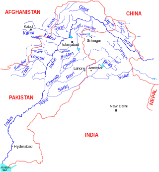
Astor River, in Pakistan's Gilgit-Baltistan administrative region, is a tributary of the Indus River and one of the rivers draining the Deosai Plateau, running through Astore Valley. The river originates from western slopes of Burzil Pass.
Dandi is a Local Government Area (LGA) in Kebbi State, Nigeria, sharing a boundary with the Republic of Niger. Its headquarters are in the town of Kamba. Dandi shares a southern border with Bunza LGA.
Felsőrajk is a village in Zala County, Hungary.
German submarine U-683 was a Type VIIC U-boat of Nazi Germany's Kriegsmarine during World War II. The submarine was laid down on 23 December 1942 at the Howaldtswerke yard at Hamburg, launched on 7 March 1944, and commissioned on 30 May 1944 under the command of Oberleutnant zur See Günter Keller.


