Reynolds Heights, Pennsylvania | |
|---|---|
 | |
| Country | United States |
| State | Pennsylvania |
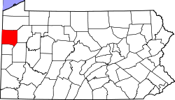
| County | Mercer |
| Area | |
• Total | 2.91 sq mi (7.53 km2) |
| • Land | 2.90 sq mi (7.52 km2) |
| • Water | 0.01 sq mi (0.01 km2) |
| Population | |
• Total | 1,974 |
| • Density | 679.75/sq mi (262.49/km2) |
| Time zone | UTC-5 (Eastern (EST)) |
| • Summer (DST) | UTC-4 (EDT) |
| FIPS code | 42-64368 |
Reynolds Heights is a census-designated place [3] located in Pymatuning Township and in Mercer County in the state of Pennsylvania. The community is located off Pennsylvania Route 18. As of the 2010 census [4] the population was 2,061 residents, which fell to 1,974 inhabitants at the 2020 Census. It is part of the Hermitage micropolitan area.