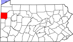
French Creek Township, Mercer County, Pennsylvania

Last updated
French Creek Township,
Mercer County, Pennsylvania
Farmstead with pond, Carter Road.jpg
Farmstead on Carter Road
Map of French Creek Township, Mercer County, Pennsylvania Highlighted.png
Location of French Creek Township in Mercer County
Map of Pennsylvania highlighting Mercer County.svg
Location of Mercer County in Pennsylvania
Country United States
State Pennsylvania
County Mercer
Area
[1]
  Total20.86 sq mi (54.02 km2)
  Land20.72 sq mi (53.67 km2)
  Water0.13 sq mi (0.35 km2)
Population
 (2020)
  Total710
  Estimate 
(2021) [2]
702
  Density36.00/sq mi (13.90/km2)
Time zone UTC-4 (EST)
  Summer (DST) UTC-5 (EDT)
Area codes 724, 814
Historical population
CensusPop.
2000 764
2010 7710.9%
2020 710−7.9%
2021 (est.)702 [2] −1.1%
U.S. Decennial Census [3]

French Creek Township is a township in Mercer County, Pennsylvania, United States. The population was 710 at the 2020 census, [2] a decrease from the figure of 771 in 2010. [4]

Contents

History

The Bridge in French Creek Township was listed on the National Register of Historic Places in 1988. [5]

Geography

According to the United States Census Bureau, the township has a total area of 20.8 square miles (54 km2), of which 20.7 square miles (54 km2) is land and 0.1 square miles (0.26 km2) (0.58%) is water.

Demographics

As of the census [6] of 2000, there were 764 people, 280 households, and 211 families residing in the township. The population density was 36.9 people per square mile (14.2/km2). There were 309 housing units at an average density of 14.9/sq mi (5.8/km2). The racial makeup of the township was 99.48% White, 0.13% Asian, 0.26% Pacific Islander, 0.13% from other races. Hispanic or Latino of any race were 0.79% of the population.

There were 280 households, out of which 35.7% had children under the age of 18 living with them, 66.8% were married couples living together, 6.4% had a female householder with no husband present, and 24.3% were non-families. 20.0% of all households were made up of individuals, and 7.5% had someone living alone who was 65 years of age or older. The average household size was 2.57 and the average family size was 2.99.

In the township the population was spread out, with 24.9% under the age of 18, 5.5% from 18 to 24, 28.0% from 25 to 44, 25.8% from 45 to 64, and 15.8% who were 65 years of age or older. The median age was 40 years. For every 100 females there were 99.5 males. For every 100 females age 18 and over, there were 95.9 males.

The median income for a household in the township was $35,568, and the median income for a family was $43,333. Males had a median income of $31,786 versus $23,125 for females. The per capita income for the township was $16,064. About 7.6% of families and 11.3% of the population were below the poverty line, including 14.5% of those under age 18 and 8.1% of those age 65 or over.

Related Research Articles

Clam Union Township, Michigan Civil township in Michigan, United States

Clam Union Township is a civil township of Missaukee County in the U.S. state of Michigan. The population was 882 at the 2010 census.

Conewago Township, Adams County, Pennsylvania Township in Pennsylvania, United States

Conewago Township is a township in Adams County, Pennsylvania, United States. The population was 7,085 at the 2010 census.

Hamilton Township, Adams County, Pennsylvania Township in Pennsylvania, United States

Hamilton Township is a township in Adams County, Pennsylvania, United States. The population was 2,530 at the 2010 census.

Halfmoon Township, Centre County, Pennsylvania Township in Pennsylvania, United States

Halfmoon Township is a township in Centre County, Pennsylvania, United States. It is part of the State College, Pennsylvania Metropolitan Statistical Area. The population was 2,667 at the 2010 census, which is a 13.2% increase since the 2000 census.

Penn Township, Clearfield County, Pennsylvania Township in Pennsylvania, United States

Penn Township is a township in Clearfield County, Pennsylvania, United States. The population was 1,264 at the 2010 census.

Wayne Township, Dauphin County, Pennsylvania Township in Pennsylvania, United States

Wayne Township is a township in Dauphin County, Pennsylvania, United States. The population was 1,341 at the 2010 census.

Burrell Township, Indiana County, Pennsylvania Township in Pennsylvania, United States

Burrell Township is a township in Indiana County, Pennsylvania, United States. Burrell Township was formed from Black Lick Township in 1853, named after Judge Burrell. The population was 3525 at the 2020 census, down from 4,393 at the 2010 census. The township includes the communities of Bell's Mills, Black Lick, Campbells Mill, Fairfield Heights, Josephine, Marshall Heights, Oake's Point, Palmertown, Smith, and Strangford.

West Wheatfield Township, Indiana County, Pennsylvania Township in Pennsylvania, United States

West Wheatfield Township is a township in Indiana County, Pennsylvania, United States. The population was 2,164 at the 2020 census. The township includes the communities of Centerville, Climax, Clyde, Conpitt Junction, Germany, Heshbon, India, and Robinson.

Spruce Hill Township, Juniata County, Pennsylvania Township in Pennsylvania, United States

Spruce Hill Township is a township in Juniata County, Pennsylvania, United States. The population was 834 at the 2010 census, up from 724 at the 2000 census.

Salisbury Township, Lancaster County, Pennsylvania Township in Pennsylvania, United States

Salisbury Township is a township in east central Lancaster County, Pennsylvania, United States. The population was 11,062 at the 2010 census.

Greene Township, Mercer County, Pennsylvania Township in Pennsylvania, United States

Greene Township is a township in Mercer County, Pennsylvania, United States. At the 2020 census, the township population was 1,051, down from 1,091 in 2010.

Mill Creek Township, Mercer County, Pennsylvania Township in Pennsylvania, United States

Mill Creek Township is a township in Mercer County, Pennsylvania, United States. The population was 776 at the 2020 census, down from 721 in 2010.

Salem Township, Mercer County, Pennsylvania Township in Pennsylvania, United States

Salem Township is a township in Mercer County, Pennsylvania, United States. The population was 752 at the 2020 census, down from 754 in 2010.

Sandy Creek Township, Mercer County, Pennsylvania Township in Pennsylvania, United States

Sandy Creek Township is a township in Mercer County, Pennsylvania, United States. The population was 800 at the 2020 census, up from 795 in 2010.

Saville Township, Perry County, Pennsylvania Township in Pennsylvania, United States

Saville Township is a second-class township in a mountainous part of Perry County, Pennsylvania, United States. As of the 2010 census, the township had a total population of 2,502. It was founded in 1817, dividing from Tyrone Township while the area was still part of Cumberland County. It is served by two major roads, PA 74, locally called Veterans Way, and PA 17, called the Tuscorara Path. The county office is at 3954 Veterans Way, in Elliottsburg, in the far southern part of the township. The area is overwhelmingly agricultural, with small population centers in Ickesburg and the hamlet of Saville.

Hebron Township, Potter County, Pennsylvania Township in Pennsylvania, United States

Hebron Township is a township in Potter County, Pennsylvania, United States. The population was 622 at the 2000 census.

Homer Township, Potter County, Pennsylvania Township in Pennsylvania, United States

Homer Township is a township in Potter County, Pennsylvania, United States. The population was 390 at the 2000 census.

South Franklin Township, Washington County, Pennsylvania Township in Pennsylvania, United States

South Franklin Township is a township in Washington County, Pennsylvania, United States. The population was 3,310 at the 2010 census.

Carroll Township, York County, Pennsylvania Township in Pennsylvania, United States

Carroll Township is a township in York County, Pennsylvania, United States. The population was 6,853 at the 2020 census.

Ogdensburg, Wisconsin Village in Wisconsin, United States

Ogdensburg is a village in Waupaca County, Wisconsin, United States. The population was 185 at the 2010 census.

References

  1. "2016 U.S. Gazetteer Files". United States Census Bureau. Retrieved Aug 14, 2017.
  2. 1 2 3 Bureau, US Census. "City and Town Population Totals: 2020-2021". Census.gov. US Census Bureau. Retrieved 26 June 2022.
  3. "Census of Population and Housing". Census.gov. Retrieved June 4, 2016.
  4. "U.S. Census website". United States Census Bureau . Retrieved 2017-03-05.
  5. "National Register Information System". National Register of Historic Places . National Park Service. July 9, 2010.
  6. "U.S. Census website". United States Census Bureau . Retrieved 2008-01-31.

Coordinates: 41°27′00″N80°01′59″W / 41.45000°N 80.03306°W / 41.45000; -80.03306