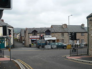
Ruthin is a market town and community in Denbighshire, Wales, in the south of the Vale of Clwyd. It is Denbighshire's county town. The town, castle and St Peter's Square lie on a hill, skirted by villages such as Pwllglas and Rhewl. The name comes from the Welsh rhudd (red) and din (fort), after the colour of sandstone bedrock, from which the castle was built in 1277–1284. The Old Mill, Ruthin, is nearby. Maen Huail, a registered ancient monument attributed to the brother of Gildas and King Arthur, stands in St Peter's Square.

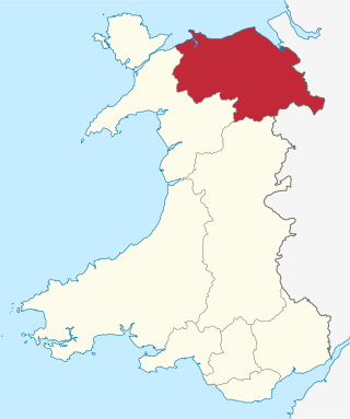
Denbighshire is a county in the north-east of Wales. It borders the Irish Sea to the north, Flintshire to the east, Wrexham to the southeast, Powys to the south, and Gwynedd and Conwy to the west. Rhyl is the largest town, and Ruthin is the administrative centre. Its borders differ from the historic county of the same name.

Until 1974, Denbighshire, or the County of Denbigh, was an administrative county in the north of Wales, later classed as one of the thirteen historic counties of Wales. It was a maritime county, that was bounded to the north by the Irish Sea, to the east by Flintshire, Cheshire and Shropshire, to the south by Montgomeryshire and Merionethshire, and to the west by Caernarfonshire.

The River Clwyd is a river in Wales that rises in the Clocaenog Forest 5 mi (8 km) northwest of Corwen. Its total length is 35 mi (56 km).
Clwyd is a preserved county of Wales, situated in the north-east corner of the country; it is named after the River Clwyd, which runs through the area. To the north lies the Irish Sea, with the English ceremonial counties of Cheshire to the east and Shropshire to the south-east. Powys and Gwynedd lie to the south and west respectively. Clwyd also shares a maritime boundary with Merseyside along the River Dee. Between 1974 and 1996, a slightly different area had a county council, with local government functions shared with six district councils. In 1996, Clwyd was abolished, and the new principal areas of Conwy County Borough, Denbighshire, Flintshire and Wrexham County Borough were created; under this reorganisation, "Clwyd" became a preserved county, with the name being retained for certain ceremonial functions.

Denbigh is a market town and a community in Denbighshire, Wales. Formerly the county town of the historic county of Denbighshire until 1888, Denbigh's Welsh name translates to "Little Fortress"; a reference to its historic castle. Denbigh lies near the Clwydian Hills.
The Vale of Clwyd is a tract of low-lying ground in the county of Denbighshire in north-east Wales. The Vale extends south-southwestwards from the coast of the Irish Sea for some 20 miles forming a triangle of low ground bounded on its eastern side by the well-defined scarp of the Clwydian Range and to the west by numerous low hills. The River Clwyd which rises within Clocaenog Forest, southwest of Denbigh, runs the full length of the vale. It is joined by the two major left bank tributaries of the River Clywedog and River Elwy and the smaller right bank tributary of the River Wheeler.

Coedpoeth is a village and community in Wrexham County Borough, Wales. The built-up area with Minera had a population of 5,723 in the 2011 census.

The A525 is a major route from Rhyl in Wales to Newcastle-under-Lyme in England. The route passes near Denbigh, through Ruthin, through Wrexham and near Whitchurch.

Corwen railway station refers to two stations, on different sites, which have existed in the town of Corwen in Denbighshire, Wales.
The Denbigh, Ruthin and Corwen Railway was a standard gauge railway line that connected Corwen with Denbigh via Ruthin in North Wales.

Ruthin Railway Station served the town of Ruthin in Denbighshire, Wales, between the 1862 and 1962. It was the main headquarters of the Denbigh, Ruthin and Corwen Railway. It had two platforms, a bay siding and a goods shed that opened into a second bay platform. The station was demolished after its closure and the Ruthin Craft Centre was built in its place. A goods crane at the Craft Centre's car park entrance is all that remains of the station.

Bryn Offa is a local-authority housing estate in the south-western suburbs of the city of Wrexham, in Wrexham County Borough, north-east Wales in the community of Offa, and is close to the Wrexham Maelor Hospital.
Trefnant is a village and community in Denbighshire, Wales. It is located on the A525 road in the Vale of Clwyd, about halfway between St Asaph (Llanelwy) to the north and Denbigh to the south. At the 2001 Census, the community had a population of 1,409, increasing to 1,581 at the 2011 Census.

Llanrhaeadr-yng-Nghinmeirch is a village and local government community in Denbighshire, Wales, including the villages of Llanrhaeadr and Pentre Llanrhaeadr and several hamlets, including Saron, Pant Pastynog, Prion, Peniel and part of Mynydd Hiraethog. It lies in the Vale of Clwyd near the A525 road between Denbigh and Ruthin. It was also known under the anglicised spellings of Llanrhaiadr in Kinmerch in the nineteenth century, and Llanrhaiadr yn Cinmerch, officially until 6 September 1968. The Community population taken at the 2011 census was 1,038.

The River Clywedog is a tributary of the River Clwyd in northeast Wales. The river rises within Clocaenog Forest and flows in a generally easterly direction through the villages of Cyffylliog, Bontuchel and Rhewl before turning northwards to join the Clwyd to the east of Denbigh.

Lon Clwyd is the name of a partially completed cycle route running South from the North Wales coast. It currently links Rhyl to Rhuddlan, but has not yet been extended to communities further south such as Denbigh and Ruthin.
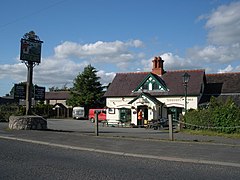
Llanynys is a hamlet and community in Denbighshire, north-east Wales;. It lies in the Vale of Clwyd, a few miles north of Ruthin, and includes the village of Rhewl.
Rhewl railway station was a station in Rhewl, Llanynys, Denbighshire, Wales. The station was opened on 1 March 1862 and closed on 30 April 1962. The main station building and sections of the platform are still extant and in use as a private dwelling.