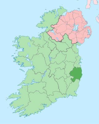
County Wicklow is a county in Ireland. The last of the traditional 32 counties, having been formed as late as 1606, it is part of the Eastern and Midland Region and the province of Leinster. It is bordered by the Irish Sea to the east and the counties of Wexford to the south, Carlow to the southwest, Kildare to the west, and South Dublin and Dún Laoghaire–Rathdown to the north.

The River Clwyd is a river in Wales that rises in the Clocaenog Forest 5 mi (8 km) northwest of Corwen. Its total length is 35 mi (56 km).

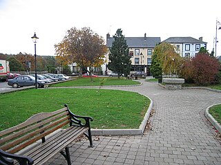
Wicklow is the county town of County Wicklow in Ireland. It is located on the east of Ireland, south of Dublin. According to the 2022 census, it had a population of 12,957 people. The town is to the east of the M11 route between Dublin and Wexford. It also has railway links to Dublin, Wexford, Arklow, and Rosslare Europort. There is also a commercial port for timber and textile imports. The River Vartry is the main river flowing through the town.

The Wicklow Mountains form the largest continuous upland area in Ireland. They occupy the whole centre of County Wicklow and stretch outside its borders into the counties of Dublin, Wexford and Carlow. Where the mountains extend into County Dublin, they are known locally as the Dublin Mountains. The highest peak is Lugnaquilla at 925 metres.

Kilmacanogue, officially Kilmacanoge, is a village in north County Wicklow, Ireland. It is southwest of Bray and is overlooked by Great Sugar Loaf mountain.

Enniscorthy is the second-largest town in County Wexford, Ireland. The town is located on the picturesque River Slaney and in close proximity to the Blackstairs Mountains and Ireland's longest beach, Curracloe.

The River Nore is one of the principal rivers in the South-East Region of Ireland. The 140-kilometre-long (87 mi) river drains approximately 2,530 square kilometres (977 sq mi) of Leinster and Munster, that encompasses parts of three counties. Along with the River Suir and River Barrow, it is one of the constituent rivers of the group known as the Three Sisters.

The River Slaney is a large river in the southeast of Ireland. It rises on Lugnaquilla Mountain in the western Wicklow Mountains and flows west and then south through counties Wicklow, Carlow and Wexford for 117.5 km (73 mi), before entering St George's Channel in the Irish Sea at Wexford town. The estuary of the Slaney is wide and shallow and is known as Wexford Harbour. The catchment area of the River Slaney is 1,762 km2. The long-term average flow rate of the River Slaney is 37.4m3/s
Bunclody, formerly Newtownbarry, is a small town on the River Slaney in Wexford, Ireland. It is located near the foot of Mount Leinster. Most of the town is in County Wexford; a small area at the north end of town is in County Carlow. Bunclody has received a number of high scores in the Tidy Towns competition. The town is known for the "Streams of Bunclody Festival" held during the month of July.

The second Battle of Arklow took place during the Irish Rebellion of 1798 on 9 June when a force of United Irishmen from Wexford, estimated at 10,000 strong, launched an assault into County Wicklow, on the British-held town of Arklow, in an attempt to spread the rebellion into Wicklow and to threaten the capital of Dublin.

The R752 road is a regional road in County Wicklow, Ireland. From its junction with the R772 in Rathnew on the outskirts of Wicklow Town it takes a generally south-westerly route to its junction with the R747 in the village of Woodenbridge, where it terminates. The road is 26 km (16 mi) long.

Clohamon is a small, rural village and townland near Bunclody in County Wexford, Ireland. Located on the River Slaney, Clonmahon's bridge dates to the late 18th or early 19th century. Previously the site of a large mill, there is now a meat processing factory in Clohamon.

The River Fergus is a river within the Shannon River Basin which flows in County Clare, Ireland. The river begins at Lough Fergus in north Clare and flows into the Shannon Estuary. The source is at Lough Fergus in the townland of Kilmore North.

The R725 road is a regional road in Ireland. From its junction with the N80 on the western outskirts of Carlow Town it takes an easterly route to its junction with the N81 in Tullow, where it crosses the River Slaney on a bridge shared with the N81 in the town centre. It continues east to Shillelagh in County Wicklow, turns due south for 6 km, then eastwards through Carnew. It then enters County Wexford for the final 15 km stretch, terminating in Gorey at the R772. The road is 53 km (33 mi) long.

Stratford-on-Slaney, also known as Stratford or Stratford-upon-Slaney, is a small village on the River Slaney in west County Wicklow in Ireland. It was built by the Earl of Aldborough from 1774. According to the census, the village had a population of 241.

The River Derry is a large river in the southeast of Leinster, Ireland, a tributary of the River Slaney. It rises just south of Hacketstown, County Carlow. It flows southeast to Tinahely, being accompanied by the R747 regional road for the distance.

The Battle of Enniscorthy was a land battle fought during the Irish Rebellion of 1798, on 28 May 1798, when an overwhelming force of rebels assailed the town of Enniscorthy, County Wexford, which was defended only by a 300-strong garrison supported by loyalist civilians. On the previous day at nearby Oulart, several thousand rebels led by Fr John Murphy had massacred a detachment of the North Cork militia, amounting to 110 officers and men.

Wexford Bridge is a road bridge in Wexford, the county town of County Wexford in Ireland. It crosses the mouth of the River Slaney from Wexford town on the west bank to Ferrybank on the east bank. It carries the R741 road from Wexford towards Dublin and the north. The bridge consists of 7 spans of maximum length 63 metres and 12 metres wide, made of continuous steel girders carrying composite concrete slabs. Including the approach roads, the total length of the bridge is 590 metres, of which 380 metres are over water.

The River Derreen is a large river in the southeast of Ireland. It rises on the southern slopes of Lybagh and Slievemaan and flows southwest until it joins the River Slaney in County Carlow, south of Tullow, passing close to Hacketstown and Tullow, County Carlow before it joins the Slaney upstream of Aghade bridge. Running through tillage and pastureland in its lower reaches, the Derreen with its sandy, gravelly bottom is a prime salmon spawning tributary of the Slaney. Passing through counties Wicklow and Carlow, it is the first large, major tributary of the River Slaney.
Ballyhogue or Ballyhoge is a village and census town in County Wexford, Ireland. The village, which lies in a townland and civil parish of the same name, had a population of 255 people as of the 2022 census. It is 10 km south of Enniscorthy.


