River Till, Lincolnshire

Last updated

River Till
River Till - geograph.org.uk - 73283.jpg
The bridge carrying Broxholme Lane over the River Till
Location
Country England
Counties Lincolnshire
Physical characteristics
Source 
  location Corringham
  elevation66 ft (20 m)
Mouth  
  location
Brayford Pool, Lincoln
  coordinates
53°13′48″N0°32′56″W / 53.2300°N 0.5488°W / 53.2300; -0.5488
  elevation
13 ft (4.0 m)

The River Till is a river in the county of Lincolnshire in England and is ultimately a tributary of the River Witham. Its upper reaches drain the land east of Gainsborough. [1] The middle section is embanked, as the water level is higher than that of the surrounding land, and pumping stations pump water from low level drainage ditches into the river. Its lower reaches from the hamlet of Odder near Saxilby into the city of Lincoln were canalised, possibly as early as Roman times, as part of the Foss Dyke. [2]

Contents

Much of the channel is managed by the Environment Agency as it is classified as a main river, while the upper river and the land drainage ditches which border the river are managed by the Upper Witham internal drainage board. In order the help protect the city of Lincoln from flooding, a sluice has been built across the channel at the Till Washlands site. When flooding is a possibility, the sluice is closed, and other sluices allow the surrounding farmland to be inundated until water levels start to fall again. The defences were first used in 2000, and successfully prevented flood damage in Lincoln in the summer of 2007.

There are issues with water quality on much of the river, caused by run-off from agricultural land, physical modification of the river channel, and discharges from sewage treatment works. In 2011, a stretch of the river near Saxilby was affected by the invasive aquatic fern Azolla . An environmental project to control the fern saw some 8,000 Azolla weevils ( Stenopelmus rufinasus ) released into the river. As they feed exclusively on the fern, once the fern has been consumed they die out naturally without affecting native species.

Course

River Till
BSicon uexKHSTa.svg
BSicon uexKHSTa.svg
Sources
BSicon uexSKRZ-Au.svg
A631 road, Corringham
BSicon uexSTRl.svg
BSicon uexABZ+lr.svg
BSicon uexSTRr.svg
BSicon uexABZg+l.svg
BSicon uexCONTfq.svg
tributary
BSicon uexSTR.svg
designated main river below here
BSicon uexCONTgq.svg
BSicon uexABZg+r.svg
tributary
BSicon uexSKRZ-Yu.svg
bridge, Heapham
BSicon uexSKRZ-Yu.svg
Common Lane bridge, Upton
BSicon uexSKRZ-Yu.svg
Cow Lane bridge, Upton
BSicon uexABZg+l.svg
BSicon uexCONTfq.svg
tributary
BSicon uexSKRZ-Yu.svg
Glentworth Road bridge, Kexby
BSicon uexSKRZ-Yu.svg
Fillingham Lane bridge
BSicon uexSKRZ-Yu.svg
Cot Garth Lane bridge
BSicon uexCONTgq.svg
BSicon uexSKRZ-Yuq.svg
BSicon uexABZg+r.svg
B1241 Stow Road bridge over tributary
BSicon uexSKRZ-Yu.svg
Bridge at Normanby by Stow
BSicon uexABZg+l.svg
BSicon uexCONTfq.svg
Fillingham Beck
BSicon uexSKRZ-Yu.svg
Squire's Bridge
BSicon uexSKRZ-Yu.svg
Thorpe Bridge
BSicon uexSTR.svg
BSicon uexSTR+l.svg
BSicon uexCONTfq.svg
tributary (designated main river)
BSicon uexSKRZ-Au.svg
A1500 road Tillbridge + Cricket Bridge
BSicon uexABZg+l.svg
BSicon uexSTRr.svg
BSicon uexSKRZ-Yu.svg
Broxholme Lane bridge
BSicon uexCONTgq.svg
BSicon uxWEIRl.svg
BSicon uxWEIRr.svg
BSicon uexCONTfq.svg
Sluices to control washland flooding
BSicon uxSLUICEbl.svg
sluice and pumping station
BSicon uexSTRq.svg
BSicon uxSTRbl.svg
Ingleby pumping station
BSicon uexSKRZ-Yu.svg
Broxholme Lane bridge
BSicon uxSTRbr.svg
BSicon uexSTRq.svg
Broxholme pumping station
BSicon uexSKRZ-Au.svg
A57 bridge Odder
BSicon uCONTgq.svg
BSicon ueFABZqlr.svg
BSicon uSTR+r.svg
Foss Dyke
BSicon uddSTRr.svg
Burton Waters marina
BSicon uexSTR.svg
BSicon CONTg.svg
BSicon uSTR.svg
Main Drain + Sheffield-Lincoln Line
BSicon uexSKRZ-Au.svg
BSicon SKRZ-Au.svg
BSicon uSKRZ-Au.svg
A46 Newark Road bridge
BSicon uexABZg+l.svg
BSicon emKRZo.svg
BSicon ueKRZo.svg
BSicon uexCONTfq.svg
Main drain
BSicon uexCONTgq.svg
BSicon uexSTR+r.svg
BSicon uexSTR.svg
BSicon STR.svg
BSicon ueABZg+l.svg
BSicon uexCONTfq.svg
Catchwater drain
BSicon CONTgq.svg
BSicon uxmKRZu.svg
BSicon uxmKRZu.svg
BSicon ABZgr+r.svg
BSicon uSTR.svg
Nottingham–Lincoln line
BSicon uexSKRZ-Yu.svg
BSicon SKRZ-Yu.svg
BSicon uSKRZ-Yu.svg
B1009 and B1273 bridges
BSicon uexSTR.svg
BSicon uexSTR.svg
BSicon STR.svg
BSicon uDOCKSa.svg
Brayford Pool, Lincoln
BSicon uexCONTgq.svg
BSicon uexFKRZ.svg
BSicon uexKRZu.svg
BSicon emKRZo.svg
BSicon uDOCKSe.svg
River Witham
BSicon uxWEIRg.svg
BSicon uexSTR.svg
BSicon STR.svg
BSicon uSKRZ-Au.svg
A57 bridge
BSicon uexSTRl.svg
BSicon uexABZg+r.svg
BSicon STR.svg
BSicon uKRZuw.svg
Lincoln High Bridge or Glory Hole
BSicon uexSTR.svg
BSicon BHF.svg
BSicon uSTR.svg
Lincoln railway station
BSicon POINTERg@fq.svg
BSicon uexSTR.svg
BSicon STR.svg
BSicon uSTR.svg
Sincil Dyke
BSicon uexCONTf.svg
BSicon CONTf.svg
BSicon uCONTf.svg
Witham Navigation

The river rises as a series of streams, close to the 66-foot (20 m) contour near Corringham, Lincolnshire, a little to the east of Gainsborough. [3] Its course heads towards the south, passing under a bridge near Heapham Windmill, [4] a grade II listed three-storey tower mill dating from around 1878, [5] and then flowing to the west of the village. Sturgate Airfield is on the east bank, and it turns briefly to the east to pass under Common Lane, and then south again, where it is crossed by Cow Lane, both minor roads leading to Upton. Upton Sewage Treatment Works is sited on the west bank, and the river passes under Glentworth Road, to the east of Kexby. The river drops below the 33-foot (10 m) contour to reach Willingham by Stow, where it skirts the eastern fringe of the village, passing under two bridges, between which is another sewage treatment works on the eastern bank. To the south of the village, it is joined by a tributary, which drains an area to the west and flows under the B1241 Stow Road to join the Till. [4]

The river turns towards the south-east, passing under another minor road, and then turns to the south again, to Squire's Bridge on Ingham Road, Stow. Passing to the east of Sturton by Stow, it is crossed by a minor road at Thorpe Bridge, and by the A1500, once the course of a Roman road, at Tillbridge. It passes to the east of Bransby and is joined by a tributary on its eastern bank, before passing to the west of Broxholme. To the north-east of Saxilby, it is crossed by Broxholme Lane, and then passes through a flood defence sluice, which is used to cause local flooding of the washlands at times when Lincoln might otherwise be flooded. Beyond is a land drainage pumping station, and another bridge also carrying Broxholme Lane. The A57 road runs along the north bank of the Foss Dyke, and crosses the Till where it joins the Foss Dyke. [4]

The final section is normally known as the Foss Dyke, although it can be considered as a canalisation of the lower Till. The construction of the Foss Dyke is often considered to date from Roman times, although this is debated by scholars, but the present channel dates from the 18th century. [6] The channel flows in a south-easterly direction, and there is an off-line marina[ clarification needed ] at Burton Waters, built in connection with a housing development. The Lincoln to Gainsborough railway line runs along the southern bank, and both are crossed by the A46 road. An aqueduct carries the Foss Dyke over a drainage channel called the Main Drain, and the A57 road crosses again as the river enters Brayford Pool, a widening of the River Witham in the centre of Lincoln. [4]

History

The River Till drains an area of Lincolnshire bounded by Gainsborough in the north-west and Lincoln in the south-east, where it joins the River Witham at Brayford Pool. The river is enclosed by earth embankments on both sides of the channel, to increase its capacity and to prevent flood water from inundating the surrounding land. These stretch from Stow Road Bridge to its junction with the Foss Dyke. [7] Lincolnshire suffered severe flooding in 1795, when the River Trent breached its bank at Spalford, inundating some 20,000 acres (81 km2) between the Trent and Lincoln, including swamp land at Broxholme and land at Saxilby where gorse and ling were grown. Lincoln High Street acted as a dam, penning the water to the west of the city, where water levels on the Foss Dyke were some 8 feet (2.4 m) above normal levels, and the flood water remained there for nearly three weeks. Following the disaster, an Act of Parliament was obtained on 20 July 1804, which created two drainage boards, the Lincoln West (North District) board being responsible for some 1,540 acres (620 ha) straddling the Foss Dyke and the River Till, while the Lincoln West (South District) board had responsibility for 2,330 acres (940 ha) bordering the upper Witham. The boards were required to embank and drain the lands. [8] The banks of the Till were extended during the 20th century, although below Tillbridge most were in place by 1886, when the first Ordnance Survey maps of the area were published. [9]

The Till Washlands main sluice allows the flow of the river to be stopped during a flood event. Till Washland Main Sluice.jpg
The Till Washlands main sluice allows the flow of the river to be stopped during a flood event.
The west sluice allows washland to be flooded to the west of the river to protect the city of Lincoln. Till Washlands West Sluice.jpg
The west sluice allows washland to be flooded to the west of the river to protect the city of Lincoln.

Water from land to the south of the Till drained into the Sincil Dyke through a tunnel under the River Witham. In order to drain land to the north more effectively, the Commissioners of the North District were authorised to construct a cast-iron tunnel under the Foss Dyke at Bishop Bridge, and a section of main drain which would link it to the main drain for the South District. In addition, they were to build a catchwater drain at a higher level, to intercept run-off from the high grounds, which empties into the Foss Dyke at Bishop Bridge. By the time the work was completed, together with other work in the South District, the drainage scheme was more or less as it exists today. Many of the drains were protected by sluice doors, which were operated either automatically or manually, but before 1930, some water was pumped from the land at Broxholme and Saxilby with the pumps being maintained by the Church Commissioners or private landowners. However, during flood events, levels in the main drains rose rapidly, and the pumps could often not be used when they were needed most. With the passing of the Land Drainage Act 1930, responsibilities were rationalised, with the Witham and Steeping Rivers Catchment Board having overall responsibility, and the Upper Witham Internal Drainage Board being constituted to manage the land drainage functions from 1 April 1933. The North District and South District Boards were abolished, and the Catchment Board took over the functions of the Lincolnshire and Nottinghamshire Commissioners of Sewers. Subsequent legislation resulted in the Catchment Board being replaced by the Lincolnshire River Board in 1950, the Lincolnshire River Authority in 1965, the Anglian Water Authority in 1973, the National Rivers Authority in 1989 and finally the Environment Agency from 1996. [8] Most of the Till, one of its tributaries and the Catchwater Drain are designated main rivers, and are maintained by the Environment Agency, while the upper river and the many drainage ditches bordering the lower river are the responsibility of the Upper Witham internal drainage board. [10]

Some 20,000 people live in regions of Lincoln that are susceptible to flooding. Most of the city's industrial buildings and around half of the commercial property is also at a high risk from flooding. [11] There were major floods in the city in 1947 and 1958, and the amount of water delivered to the city by the River Till was a significant factor in the 1958 floods. [12] Following these events, feasibility studies were carried out in 1977 to identify ways to mitigate flooding in the city. This resulted in the construction of two washlands, one where the River Brant joins the River Witham, to the south of Lincoln, and the other on the River Till, to the north-west. Work began in 1984, and the two schemes can hold back 340 million cubic feet (9,600 Ml) of floodwater. In both cases, a shallow embankment was constructed across the river valley, and the river passes through a control sluice, which can be used to limit the volume of water travelling downstream. Inlet and outlet sluices in the embankments can be opened to allow the water to flood the Till washlands, rather than allowing river levels in the city to breach the defences. [7] The water from the washlands is subsequently released as levels through the city return to normal. Draining of the washlands is assisted by pumping stations, and the scheme was completed in 1991. [11]

The washlands were tested for the first time in 2000, when there was some local flooding of rural areas, but the storage of water prevented significant damage occurring in Lincoln. Much more serious was a flood event in the summer of 2007, which was caused by intense rainfall, but the flood defences worked as planned, with the River Till reservoir reaching 85 per cent full before water levels began to subside. The washlands were again partially filled in January 2008. [12] A study carried out in 2010 noted that the Catchment Flood Management Plan for the Lincoln area recommends that the capacity of the washlands should be increased, to cope with the possible effects of climate change. [13]

Water quality

The Environment Agency measure the water quality of the river systems in England. Each is given an overall ecological status, which may be one of five levels: high, good, moderate, poor and bad. There are several components that are used to determine this, including biological status, which looks at the quantity and varieties of invertebrates, angiosperms and fish. Chemical status, which compares the concentrations of various chemicals against known safe concentrations, is rated good or fail. [14]

The water quality of the River Till system was as follows in 2019.

SectionEcological StatusChemical StatusLengthCatchmentChannel
Tributary of Till [15] Poor Fail 3.0 miles (4.8 km)6.62 square miles (17.1 km2)
Till (Witham) [16] Moderate Fail 8.8 miles (14.2 km)13.60 square miles (35.2 km2)heavily modified
Fillingham Beck [17] Moderate Fail 1.5 miles (2.4 km)9.39 square miles (24.3 km2)heavily modified
Lower Till [18] Moderate Fail 6.8 miles (10.9 km)19.62 square miles (50.8 km2)heavily modified
Fossdyke Canal, River Till section [19] Moderate Fail 4.3 miles (6.9 km)artificial

The reasons for the quality being less than good include run-off from agricultural and rural land, physical modification of the channel for land drainage, and sewage discharge affecting the lower river sections. Like most rivers in the UK, the chemical status changed from good to fail in 2019, due to the presence of polybrominated diphenyl ethers (PBDE), perfluorooctane sulphonate (PFOS) and mercury compounds, none of which had previously been included in the assessment. [20]

In 2011, around 2.5 miles (4 km) of the Till near Saxilby were affected by Azolla, a fast-growing aquatic fern originally imported to Britain from America in the 1840s for use in ornamental ponds. On the river, it was forming dense mats, depriving other river fauna and flora of oxygen and light. In order to combat it, the Environment Agency released 8,000 Azolla weevils (stenopelmus rufinasus) into the affected area. They feed exclusively on the fern, and were expected to increase rapidly to a population of millions in a few weeks. Because they only feed on Azolla, they die out naturally once they have consumed the weed, and do not affect native species. Previous attempts to clear the weed by mechanical means in June 2011 had not proved successful. [21]

See also

Bibliography

Related Research Articles

<span class="mw-page-title-main">River Witham</span> River in eastern England

The River Witham is a river almost entirely in the county of Lincolnshire in the east of England. It rises south of Grantham close to South Witham at SK8818, passes through the centre of Grantham, passes Lincoln at SK9771 and at Boston, TF3244, flows into The Haven, a tidal arm of The Wash, near RSPB Frampton Marsh. The name "Witham" seems to be extremely old and of unknown origin. Archaeological and documentary evidence shows the importance of the Witham as a navigable river from the Iron Age onwards. From Roman times it was navigable to Lincoln, from where the Fossdyke was constructed to link it to the River Trent. The mouth of the river moved in 1014 following severe flooding, and Boston became important as a port.

<span class="mw-page-title-main">River Welland</span> Lowland river in the east of England

The River Welland is a lowland river in the east of England, some 65 miles (105 km) long. It drains part of the Midlands eastwards to The Wash. The river rises in the Hothorpe Hills, at Sibbertoft in Northamptonshire, then flows generally northeast to Market Harborough, Stamford and Spalding, to reach The Wash near Fosdyke. It is a major waterway across the part of the Fens called South Holland, and is one of the Fenland rivers that were laid out with washlands. There are two channels between widely spaced embankments with the intention that flood waters would have space in which to spread while the tide in the estuary prevented free egress. However, after the floods of 1947, new works such as the Coronation Channel were constructed to control flooding in Spalding, and the washlands are no longer used solely as pasture, but may be used for arable farming.

<span class="mw-page-title-main">River Ancholme</span> River in Lincolnshire, England

The River Ancholme is a river in Lincolnshire, England, and a tributary of the Humber. It rises at Ancholme Head, a spring just north of the village of Ingham and immediately west of the Roman Road, Ermine Street. It flows east and then north to Bishopbridge west of Market Rasen, where it is joined by the Rase. North of there it flows through the market town of Brigg before draining into the Humber at South Ferriby. It drains a large part of northern Lincolnshire between the Trent and the North Sea.

<span class="mw-page-title-main">Old Bedford River</span> Watercourse in Cambridgeshire, England

The Old Bedford River is an artificial, partial diversion of the waters of the River Great Ouse in the Fens of Cambridgeshire, England. It was named after the fourth Earl of Bedford who contracted with the local Commission of Sewers to drain the Great Level of the Fens beginning in 1630. It provided a steeper and shorter path for the waters of the Great Ouse, and was embanked to prevent them flooding the low ground of the South Fens. Throughout the project, the Earl and his Adventurers faced disruption from those who were opposed to drainage schemes. The project was deemed to have succeeded in draining the fens in 1637, but that decision was reversed in 1638. After a lull during the English Civil War, when much of the work was damaged, the Dutch engineer Cornelius Vermuyden worked with William Russell, the fifth Earl of Bedford to complete the drainage. Disruption and unrest continued while the work was carried out, resulting in the Adventurers employing armed guards. A second river, the New Bedford River, was cut parallel to the first channel, which then became the Old Bedford River. At some point, the Old Bedford River was split into two parts, when the upper section was diverted into the River Delph at Welches Dam, and the lower section was joined to the Counter Drain. Both parts retain the name, but are not connected to each other. The area between the two Bedford rivers acts as a large washland, which holds floodwater when the river channels cannot cope with the volume of water in them.

<span class="mw-page-title-main">New Bedford River</span> Watercourse in Cambridgeshire, England

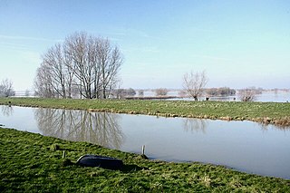
The New Bedford River, also known as the Hundred Foot Drain because of the distance between the tops of the two embankments on either side of the river, is a navigable man-made cut-off or by-pass channel of the River Great Ouse in the Fens of Cambridgeshire, England. It provides an almost straight channel between Earith and Denver Sluices. It is tidal, with reverse tidal flow being clearly visible at Welney, some 19 miles (31 km) from the sea.

<span class="mw-page-title-main">River Glen, Lincolnshire</span> River in Lincolnshire and Rutland, England

The River Glen is a river in Lincolnshire, England with a short stretch passing through Rutland near Essendine.

<span class="mw-page-title-main">Foss Dyke</span> Canal that connects the River Trent to Lincoln

The Foss Dyke, or Fossdyke, connects the River Trent at Torksey to Lincoln, the county town of Lincolnshire, and may be the oldest canal in England that is still in use. It is usually thought to have been built around AD 120 by the Romans, but there is no consensus among authors. It was refurbished in 1121, during the reign of King Henry I, and responsibility for its maintenance was transferred to the city of Lincoln by King James I. Improvements made in 1671 included a navigable sluice or lock at Torksey, and warehousing and wharves were built at Brayford Pool in the centre of Lincoln.

<span class="mw-page-title-main">River Idle</span> River in Nottinghamshire, England

The River Idle is a river in Nottinghamshire, England whose source is the confluence of the River Maun and River Meden near Markham Moor. The Idle flows north from its source through Retford and Bawtry before entering the River Trent at West Stockwith. Its main tributaries are the River Poulter and the River Ryton. The river is navigable to Bawtry, and there is a statutory right of navigation to Retford. Most of the land surrounding the river is a broad flood plain and the river is important for conservation, with Sites of Special Scientific Interest being designated along its course.

<span class="mw-page-title-main">River Lymn</span> River in Lincolnshire, England

The River Lymn is a river in Lincolnshire, England. It rises in the Wolds on the eastern slope of Castcliffe Hill in Fulletby parish. It flows south-eastwards to the Lincolnshire Marsh, where it becomes known as the Steeping River on the boundary of Great Steeping parish. The main channel is supplemented by the Wainfleet Relief Channel as it passes Wainfleet All Saints, and the relief channel is joined by the old course of the Lymn. Once the two channels rejoin, there are three flood defence structures to protect the region from flooding by the North Sea.

<span class="mw-page-title-main">South Forty-Foot Drain</span> Drainage canal in eastern England

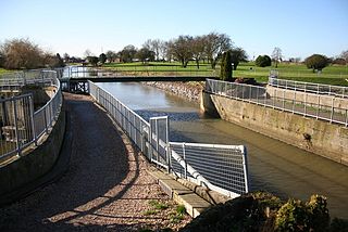
The South Forty-Foot Drain, also known as the Black Sluice Navigation, is the main channel for the land-drainage of the Black Sluice Level in the Lincolnshire Fens. It lies in eastern England between Guthram Gowt and the Black Sluice pumping station on The Haven, at Boston. The Drain has its origins in the 1630s, when the first scheme to make the Fen land available for agriculture was carried out by the Earl of Lindsey, and has been steadily improved since then. Water drained from the land entered The Haven by gravity at certain states of the tide until 1946, when the Black Sluice pumping station was commissioned.

<span class="mw-page-title-main">Hatfield Chase</span> Human settlement in England

Hatfield Chase is a low-lying area in South Yorkshire and North Lincolnshire, England, which was often flooded. It was a royal hunting ground until Charles I appointed the Dutch engineer Cornelius Vermuyden to drain it in 1626. The work involved the re-routing of the Rivers Don, Idle, and Torne, and the construction of drainage channels. It was not wholly successful, but changed the whole nature of a wide swathe of land including the Isle of Axholme, and caused legal disputes for the rest of the century. The civil engineer John Smeaton looked at the problem of wintertime flooding in the 1760s, and some remedial work was carried out.

<span class="mw-page-title-main">Fens Waterways Link</span> Waterways project in eastern England

The Fens Waterways Link is a project to improve recreational boating opportunities in the counties of Cambridgeshire and Lincolnshire, England. By a combination of improvements to existing waterways and the construction of new links a circular route between Lincoln, Peterborough, Ely and Boston is planned. The project is being organised by the Environment Agency and financed from the Regional Development Agency and the European Union.

<span class="mw-page-title-main">Barlings Eau</span> River in Lincolnshire, England

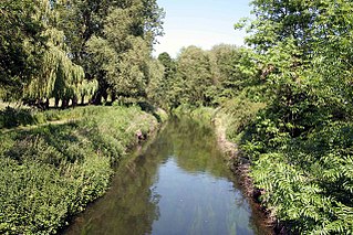
Barlings Eau is a small river near Barlings, Lincolnshire, England. It is a tributary of the River Witham, joining it near Short Ferry. It acts as the central spine for a number of other small rivers, which drain the low-lying land to either side. Most of its course is within the area managed by the Witham Third District IDB, an Internal Drainage Board responsible for land drainage. One of their pumping stations is on the banks of the river.

<span class="mw-page-title-main">Internal drainage board</span>

An internal drainage board (IDB) is a type of operating authority which is established in areas of special drainage need in England and Wales with permissive powers to undertake work to secure clean water drainage and water level management within drainage districts. The area of an IDB is not determined by county or metropolitan council boundaries, but by water catchment areas within a given region. IDBs are geographically concentrated in the Broads, Fens in East Anglia and Lincolnshire, Somerset Levels and Yorkshire.

<span class="mw-page-title-main">Witham Navigable Drains</span> United Kingdom legislation

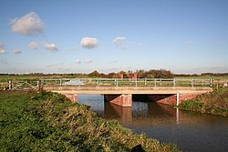
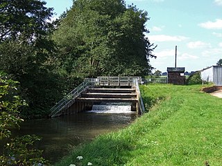
The Witham Navigable Drains are located in Lincolnshire, England, and are part of a much larger drainage system managed by the Witham Fourth District Internal Drainage Board. The Witham Fourth District comprises the East Fen and West Fen, to the north of Boston, which together cover an area of 97 square miles (250 km2). In total there are over 438 miles (705 km) of drainage ditches, of which under 60 miles (97 km) are navigable. Navigation is normally only possible in the summer months, as the drains are maintained at a lower level in winter, and are subject to sudden changes in level as a result of their primary drainage function, which can leave boats stranded. Access to the drains is from the River Witham at Anton's Gowt Lock.

<span class="mw-page-title-main">Black Sluice</span>

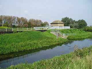
The Black Sluice is the name given to the structure that controls the flow of the South Forty-Foot Drain into The Haven, at Boston, Lincolnshire, England.

<span class="mw-page-title-main">Witham First District IDB</span> Human settlement in England

Witham First District IDB is an English internal drainage board which was set up under the terms of the Land Drainage Act 1930. The Board inherited the responsibilities of the Witham General Drainage Commissioners, who were first constituted by an Act of Parliament of 1762. They manage the land drainage of an area to the west of the River Witham, between Lincoln and Dogdyke, which includes the valley of the River Slea to above Sleaford.

<span class="mw-page-title-main">River Torne (England)</span> River in the north of England

The River Torne is a river in the north of England, which flows through the counties of South Yorkshire and North Lincolnshire. It rises at the Upper Lake at Sandbeck Hall, in Maltby in South Yorkshire, and empties into the River Trent at Keadby pumping station. Much of the channel is engineered, as it plays a significant role in the drainage of Hatfield Chase, which it crosses.

<span class="mw-page-title-main">South Holland IDB</span> Human settlement in England

South Holland IDB is an English internal drainage board set up under the terms of the Land Drainage Act 1930. It has responsibility for the land drainage of 148.43 square miles (384.4 km2) of low-lying land in South Lincolnshire. It is unusual as its catchment area is the same as the area of the drainage district, and so it does not have to deal with water flowing into the area from surrounding higher ground. No major rivers flow through the area, although the district is bounded by the River Welland to the west and the River Nene to the east.

<span class="mw-page-title-main">Upper Witham IDB</span> Human settlement in England

The Upper Witham IDB is an English Internal Drainage Board responsible for land drainage and the management of flood risk for an area to the west of the Lincolnshire city of Lincoln, broadly following the valleys of the upper River Witham, the River Till and the course of the Fossdyke Navigation.

References

  1. Agency 2014, p. 45.
  2. "Saxilby Village History". Saxilby with Ingleby Parish Council. Archived from the original on 23 July 2018. Retrieved 23 July 2018.
  3. Marsh 2009, p. 11.
  4. 1 2 3 4 Ordnance Survey, 1:25,000 map
  5. Historic England. "Heapham Windmill (1064049)". National Heritage List for England . Retrieved 28 July 2018.
  6. Marsh 2009, p. 53.
  7. 1 2 Marsh 2009, p. 28.
  8. 1 2 "History". Upper Witham IDB. Archived from the original on 17 July 2014. Retrieved 30 July 2018.
  9. "OS County Series 1:2500 map". Ordnance Survey. 1886. Retrieved 28 July 2018.
  10. "Maps". North East Lindsey IDB. Retrieved 30 July 2018.
  11. 1 2 JBA 2010, p. 4.
  12. 1 2 JBA 2010, p. 38.
  13. JBA 2010, p. 18.
  14. "Glossary (see Biological quality element; Chemical status; and Ecological status)". Catchment Data Explorer. Environment Agency. Retrieved 28 July 2018.
  15. "Tributary of Till". Catchment Data Explorer. Environment Agency. Retrieved 11 November 2021.
  16. "Till (Witham)". Catchment Data Explorer. Environment Agency. Retrieved 11 November 2021.
  17. "Fillingham Beck". Catchment Data Explorer. Environment Agency. Retrieved 11 November 2021.
  18. "Lower Till". Catchment Data Explorer. Environment Agency. Retrieved 11 November 2021.
  19. "Fossdyke Canal, River Till section". Catchment Data Explorer. Environment Agency. Retrieved 11 November 2021.
  20. "Chemical Status". Environment Agency. 2023. Archived from the original on 14 March 2024.
  21. "Weevils tackle invasive water fern on the River Till". BBC. 6 October 2011. Archived from the original on 14 September 2018. Retrieved 23 July 2018.

Commons-logo.svg Media related to River Till, Lincolnshire at Wikimedia Commons