This article relies largely or entirely on a single source .(July 2024) |
Roaring Creek | |
|---|---|
 Church and fields outside Roaring Creek | |
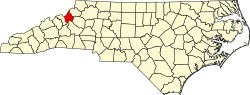
 Roaring Creek Location within the state of North Carolina | |
| Coordinates: 36°03′49″N82°00′45″W / 36.06361°N 82.01250°W | |
| Country | United States |
| State | North Carolina |
| County | Avery |
| Elevation | 2,982 ft (909 m) |
| Time zone | UTC-5 (Eastern (EST)) |
| • Summer (DST) | UTC-4 (EDT) |
| ZIP code | 28657 |
| Area code | 828 |
| GNIS feature ID | 1022311 [1] |
Roaring Creek is an unincorporated community in Avery County, North Carolina, United States. The community was named after Roaring Creek, which flows in the area. [2] The community is located along US 19-E, between the communities of Frank and Plumtree.