Heaton, North Carolina

Last updated

Heaton
USA North Carolina location map.svg
Red pog.svg
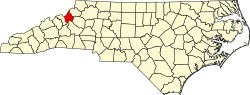
Heaton
Location within the state of North Carolina
Coordinates: 36°10′22″N81°56′33″W / 36.17278°N 81.94250°W / 36.17278; -81.94250
Country United States
State North Carolina
County Avery County
Elevation
3,045 ft (928 m)
Time zone UTC-5 (Eastern (EST))
  Summer (DST) UTC-4 (EDT)
ZIP code
28622
Area code 828
GNIS feature ID1011954 [1]

Heaton is an unincorporated community in Avery County, North Carolina, United States. The community is located along NC 194, centered at the Heaton Bridge, which crosses over the Elk River.

See also

Related Research Articles

<span class="mw-page-title-main">Watauga County, North Carolina</span> County in North Carolina, United States

Watauga County is a county located in the U.S. state of North Carolina. As of the 2020 census, the population was 54,086. Its county seat and largest town is Boone. The county is in an exceptionally mountainous region. It is the home of Appalachian State University, which has approximately 20,023 students as of August 20, 2020. Watauga County comprises the Boone, NC Micropolitan Statistical Area.

<span class="mw-page-title-main">Avery County, North Carolina</span> County in North Carolina, United States

Avery County is a county located in the U.S. state of North Carolina. As of the 2020 census, the population was 17,806. The county seat is Newland. The county seat was initially established in Elk Park when the county was first formed, but was moved to Newland upon completion of the courthouse in 1912. Founded in 1911, it is the youngest of North Carolina's 100 counties.

<span class="mw-page-title-main">Alexander County, North Carolina</span> County in North Carolina, United States

Alexander County is a county established in the U.S. state of North Carolina in 1847. As of the 2020 census, the population was 36,444. Its county seat is Taylorsville. Alexander County is part of the Hickory–Lenoir–Morganton, NC Metropolitan Statistical Area.

<span class="mw-page-title-main">Elk River, Minnesota</span> City in Minnesota, United States

Elk River is a city in Sherburne County, Minnesota, United States, approximately 34 miles northwest of Minneapolis. It is situated at the confluence of the Mississippi and Elk Rivers. The population was 25,835 at the 2020 census, making Elk River the second largest city in the Central Minnesota region after St. Cloud. It is the county seat. U.S. Highways 10 and 169 and State Highway 101 are three of the main routes in Elk River, and a station on the Northstar Commuter Rail line to downtown Minneapolis is located in the city. Elk River is located 33.2 miles northwest of Minneapolis and 37.4 miles southeast of St. Cloud.

<span class="mw-page-title-main">Banner Elk, North Carolina</span> Town in North Carolina, United States

Banner Elk is a town in Avery County, North Carolina, United States. The population was 1,028 at the 2010 census. Banner Elk is home to Lees–McRae College.

<span class="mw-page-title-main">Stone Mountain State Park</span>

Stone Mountain State Park is a 14,353-acre (58.08 km2) North Carolina state park in Alleghany County and Wilkes County, North Carolina.

Elk River may refer to:

<span class="mw-page-title-main">Elk River (Tennessee River tributary)</span> River in Alabama, United States

The Elk River is a tributary of the Tennessee River in the U.S. states of Tennessee and Alabama. The river is about 195 miles (314 km) long.

<span class="mw-page-title-main">Elk River (West Virginia)</span> River in West Virginia, United States

The Elk River is a tributary of the Kanawha River, 172 miles (277 km) long, in central West Virginia in the United States. Via the Kanawha and Ohio rivers, it is part of the watershed of the Mississippi River.

<span class="mw-page-title-main">U.S. Route 19E</span> Suffixed section of U.S. Highway in Tennessee and North Carolina

U.S. Route 19E (US 19E) is a divided highway of US 19 in the U.S. states of North Carolina and Tennessee. The United States Numbered Highway, which is complemented by US 19W to the west, travels 75.9 miles (122.1 km) from US 19 and US 19W at Cane River, North Carolina, north to US 11E, US 19, and US 19W in Bluff City, Tennessee. US 19E connects Asheville, North Carolina, and Bristol, Tennessee, with Burnsville, Spruce Pine, and Elk Park in North Carolina and Roan Mountain and Elizabethton in Tennessee. US 19E also has an unsigned concurrency with State Route 37 (SR 37) for its entire course in Tennessee.

<span class="mw-page-title-main">U.S. Route 19W</span> Suffixed section of U.S. Highway in Tennessee and North Carolina

U.S. Route 19W (US 19W) traverses approximately 63 miles (101 km) from Cane River, North Carolina, to Bluff City, Tennessee.

<span class="mw-page-title-main">Elk River (North Carolina–Tennessee)</span> River in Tennessee, United States

The Elk River is a large stream in the North Carolina High Country and East Tennessee. The headwaters begin from the Northwestern slopes of Peak Mountain in Avery County, North Carolina and end at the Watauga River in Carter County, Tennessee.

<span class="mw-page-title-main">Western North Carolina</span> Geographic region of the U.S. state of North Carolina

Western North Carolina is the region of North Carolina which includes the Appalachian Mountains; it is often known geographically as the state's Mountain Region. It contains the highest mountains in the Eastern United States, with 125 peaks rising to over 5,000 feet in elevation. Mount Mitchell at 6,684 feet, is the highest peak of the Appalachian Mountains and mainland eastern North America. The population of the region, as measured by the 2010 U.S. Census, is 1,473,241, which is approximately 15% of North Carolina's total population.

<span class="mw-page-title-main">Elk Knob State Park</span>

Elk Knob State Park is a 4,423-acre (17.90 km2) North Carolina state park in Watauga County, North Carolina, in the United States. Opened in 2003, it is one of North Carolina's newest state parks. Elk Knob State Park was established to preserve the natural state of Elk Knob, the third highest peak in Watauga County. The park is open for year-round recreation and is currently undergoing an expansion of facilities to provide greater recreational opportunities to visitors. Elk Knob State Park is on Meat Camp Road, 5.5 miles (8.9 km) from North Carolina Highway 194, 9.5 miles (15.3 km) north of Boone, in the Blue Ridge Mountains.

<span class="mw-page-title-main">Todd, North Carolina</span>

Todd is an unincorporated community straddling the county lines of Watauga and Ashe counties in northwestern North Carolina, United States on the South Fork of the New River. It lies at an elevation of 2,992 feet. The population was 2,141 at the 2010 United States Census. The ZIP Code for Todd is 28684.

<span class="mw-page-title-main">Shawneehaw Creek</span> River in North Carolina, United States

The Shawneehaw Creek is a stream in the North Carolina High Country and is named after a Cherokee word for a tree that blooms early in the Spring, the current name for the tree is Serviceberry, or sarvisberry, and is located in the town of Banner Elk. The headwaters begin from the Southeastern slopes of Beech Mountain in Watauga County, North Carolina and end at the Elk River in Avery County, North Carolina.The tree extend from North Carolina to Louisiana and Florida, and to 6000 feet.

<span class="mw-page-title-main">North Carolina Highway 194</span> State highway in North Carolina, US

North Carolina Highway 194 (NC 194) is a primary state highway in the U.S. state of North Carolina. Entirely in the High Country, it runs from US 19E, in Ingalls, to the Virginia state line, near Helton.

<span class="mw-page-title-main">Snake Mountain (North Carolina – Tennessee)</span> Mountain in United States of America

Snake Mountain is a mountain located along the border of North Carolina and Tennessee, east of the community of Zionville, in the southeastern United States. It is part of the Blue Ridge Mountains, and includes parts of Watauga County, North Carolina, and Johnson County, Tennessee. It has two peaks, the higher of which reaches an elevation of 5,564 feet (1,696 m). The lower peak, at 5,518 feet (1,682 m), is Johnson County's high point.

Elk Knob is a mountain in the North Carolina High Country, north of the community of Meat Camp. Its elevation reaches 5,538 feet (1,688 m).

References