Vale | |
|---|---|
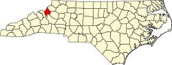
 Vale Location within the state of North Carolina | |
| Coordinates: 36°05′49″N81°56′42″W / 36.09694°N 81.94500°W | |
| Country | United States |
| State | North Carolina |
| County | Avery County |
| Elevation | 3,550 ft (1,082 m) |
| Time zone | UTC-5 (Eastern (EST)) |
| • Summer (DST) | UTC-4 (EDT) |
| ZIP code | 28657 |
| Area code | 828 |
| GNIS feature ID | 1023058 [1] |
Vale is an unincorporated community in Avery County, North Carolina, United States. It is located northwest of Newland on Old Toe River Road.