Linville Falls, North Carolina

Last updated
Linville Falls, North Carolina
Linville Falls Tavern.jpg
USA North Carolina location map.svg
Red pog.svg
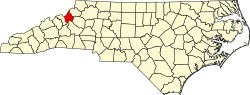
Linville Falls
Location within the state of North Carolina
Coordinates: 35°59′27″N81°56′39″W / 35.99083°N 81.94417°W / 35.99083; -81.94417
Country United States
State North Carolina
County Avery, Burke, McDowell [1]
Named for Linville Falls [2]
Elevation
3,268 ft (996 m)
Time zone UTC-5 (Eastern (EST))
  Summer (DST) UTC-4 (EDT)
ZIP code
28647
Area code 828
GNIS feature ID1012893 [1]

Linville Falls is an unincorporated community located at the junction of Avery, Burke, and McDowell counties in the U.S. state of North Carolina. [1] It is named after Linville Falls, a nearby waterfall in the Linville Gorge Wilderness.

Contents

Attractions

Linville Falls is close to many of western North Carolina's outdoor attractions.

The Linville Falls Tavern was listed on the National Register of Historic Places in 2000 and the Franklin-Penland House in 2006. [3]

See also

Related Research Articles

<span class="mw-page-title-main">Burke County, North Carolina</span> County in North Carolina, United States

Burke County is a county located in the U.S. state of North Carolina. As of the 2020 census, its population was 87,570. Its county seat is Morganton.

<span class="mw-page-title-main">Blue Ridge Parkway</span> Scenic parkway in the United States

The Blue Ridge Parkway is a National Parkway and All-American Road in the United States, noted for its scenic beauty. The parkway, which is the longest linear park in the U.S., runs for 469 miles (755 km) through 29 counties in Virginia and North Carolina, linking Shenandoah National Park to Great Smoky Mountains National Park. It runs mostly along the spine of the Blue Ridge, a major mountain chain that is part of the Appalachian Mountains. Its southern terminus is at U.S. Route 441 (US 441) on the boundary between Great Smoky Mountains National Park and the Qualla Boundary of the Eastern Band of Cherokee Indians in North Carolina, from which it travels north to Shenandoah National Park in Virginia. The roadway continues through Shenandoah as Skyline Drive, a similar scenic road which is managed by a different National Park Service unit. Both Skyline Drive and the Virginia portion of the Blue Ridge Parkway are part of Virginia State Route 48 (SR 48), though this designation is not signed.

<span class="mw-page-title-main">Pisgah National Forest</span> National forest in North Carolina

Pisgah National Forest is a National Forest in the Appalachian Mountains of western North Carolina. It is administered by the United States Forest Service, part of the United States Department of Agriculture. The Pisgah National Forest is completely contained within the state of North Carolina. The forest is managed together with the other three North Carolina National Forests from common headquarters in Asheville, North Carolina. There are local ranger district offices located in Pisgah Forest, Mars Hill, and Nebo.

<span class="mw-page-title-main">National Register of Historic Places listings in North Carolina</span>

This is a list of structures, sites, districts, and objects on the National Register of Historic Places in North Carolina:

<span class="mw-page-title-main">Linville Gorge Wilderness</span> Protected area in North Carolina, United States

The Linville Gorge Wilderness is the third largest wilderness area in North Carolina and one of only two wilderness gorges in the Southern United States. Maintained by the United States Forest Service, it comprises 11,786 acres (47.70 km2) around the Linville River, and is situated inside the Pisgah National Forest. The river is approximately 1,400 feet (430 m) below the ridge, thus hiking in and out of the Gorge is challenging and enjoyable for those who like serious hiking. The plant and animal community is extremely diverse, with a dense hardwood/pine forest and a wide variety of smaller trees and other plants as well as bear, fox, raccoon, trout, grouse, wild turkey, vultures, owls, hawks, copperheads, and timber rattlesnakes.

<span class="mw-page-title-main">Shining Rock Wilderness</span> Protected wilderness in the U.S. state of North Carolina

Named for Shining Rock, the Shining Rock Wilderness is a protected Wilderness Area in Haywood County, North Carolina. Its first 13,400 acres (54 km2) have been part of the National Wilderness Preservation System since the System was created in 1964. It now includes 18,483 acres (74.80 km2), and is managed by the United States Forest Service as part of the Pisgah National Forest. It is separated from Middle Prong Wilderness to the southwest, by NC 215.

<span class="mw-page-title-main">Ellicott Rock Wilderness</span> Wild area lying at and around the tripoint of Georgia, North Carolina and South Carolina

Ellicott Rock Wilderness is a wild area lying at and around the tripoint of Georgia, North Carolina, and South Carolina, spanning 8,274 acres. It is managed by the United States Forest Service and is part of the National Wilderness Preservation System.

<span class="mw-page-title-main">Linville Falls</span> Waterfall in Burke County, North Carolina

Linville Falls is a waterfall located in the Blue Ridge Mountains of North Carolina in the United States. The falls move in several distinct steps, beginning in a twin set of upper falls, moving down a small gorge, and culminating in a high-volume 45-foot (14 m) drop.

<span class="mw-page-title-main">Linville River</span> River in North Carolina, United States

The Linville River is a river in western North Carolina, United States. The river begins in the slopes of Peak Mountain, Sugar Mountain and Flattop Mountain, in the Linville Gap area. As it goes south through Avery County, it passes through the communities of Grandfather, Linville, Pineola, Crossnore and finally at Linville Falls. After entering Burke County at the community of Linville Falls, the river becomes the centerpiece of the Linville Falls and the Linville Gorge, an area referred to as "the Grand Canyon of North Carolina." After approximately 30 miles (48 km), the river ends at Lake James and the Catawba River; the original confluence with the Catawba River has been flooded by the creation of the reservoir in 1923.

<span class="mw-page-title-main">Linville, North Carolina</span> Census-designated place in North Carolina, United States

Linville is an unincorporated community and census-designated place (CDP) in Avery County, North Carolina, United States. It was first listed as a CDP in the 2020 census with a population of 283. Centered just south of US 221 and NC 105, the community is known as a summer mountain resort and host of the Grandfather Mountain Highland Games, the largest modern Highland games events in North Carolina.

Linville may refer to:

<span class="mw-page-title-main">Table Rock (North Carolina)</span> Mountain in North Carolina, United States

Table Rock is a mountain in the east rim of Linville Gorge, part of Pisgah National Forest in North Carolina. It features a distinctive rock formation, and is a prominent peak in the area.

<span class="mw-page-title-main">North Carolina Highway 105</span> State highway in North Carolina, US

North Carolina Highway 105 (NC 105) is a primary state highway in the U.S. state of North Carolina. It traverses from the mountain community of Linville to the town of Boone.

<span class="mw-page-title-main">North Carolina Highway 183</span> State highway in North Carolina, US

North Carolina Highway 183 (NC 183) is a primary state highway in the U.S. state of North Carolina. It traverses from US 221, in the community of Linville Falls, to NC 181, near the community of Jonas Ridge.

Altamont is an unincorporated community in Avery County, North Carolina, United States. The community is located along US 221/NC 194, between the town of Crossnore and the community of Linville Falls. Altamont translates to "High Mountain."

<span class="mw-page-title-main">Linville, Virginia</span> Census-designated place in Virginia, United States

Linville is a Census-designated place located in Rockingham County, in the U.S. state of Virginia. It is located 6 miles north of Harrisonburg, Virginia. It is for the first time listed as CDP for the United States Census 2020. It contains the Linville United Church of Christ.

<span class="mw-page-title-main">Linville Historic District</span> Historic district in North Carolina, United States

Linville Historic District is a historic school campus and national historic district located at Linville, Avery County, North Carolina. It encompasses 96 contributing buildings and 4 contributing structures in the historic core of Linville. The buildings date between about 1892 and 1940, and include shingle-or chestnut bark-covered resort buildings and the second generation of houses flanking the first and eighteenth fairways of the golf course. Notable buildings include the Hemlock Cottage, Dormiecroft, "Honeymoon" Cottage, Presbyterian Church, The Studio, the VanLandingham House, and All Saints Episcopal Church.

<span class="mw-page-title-main">Linville Falls Tavern</span> United States historic place

Linville Falls Tavern, now known as Famous Louise's Rock House Restaurant, is a historic tavern located at Linville Falls, at the tri-point between Burke County, Avery County, and McDowell County, North Carolina. It was built in 1936, and is a 1+12-story, eight-bay, native stone Rustic Revival-style building. It has a hipped roof with dormers and two stone chimneys.

<span class="mw-page-title-main">Franklin-Penland House</span> Historic house in North Carolina, United States

Franklin-Penland House, also known as Theodore C. Franklin House, Stokes Penland House, and Linville Falls Post Office, is a historic home located at Linville Falls, Burke County, North Carolina. It was built about 1883, and is a two-story, three-bay, frame I-house with a two-story rear ell. It features a full-width, attached two-tiered shed roof porch added about 1915. Also on the property is the former U.S. Post Office, Linville Falls, N.C., building. The one-room front gable frame building was built in 1907 and housed the Linville Falls post office until 1925.

<span class="mw-page-title-main">Protected areas of North Carolina</span> North Carolina protected areas

The protected areas of North Carolina cover roughly 3.8 million acres, making up 11% of the total land in the state. 86.5% of this protected land is publicly owned and is managed by different federal and state level authorities and receive varying levels of protection. Some areas are managed as wilderness while others are operated with acceptable commercial exploitation. The remainder of the land is privately owned, but willingly entered into conservation easement management agreements, or are owned by various nonprofit conservation groups such as the National Audubon Society and The Nature Conservancy. North Carolina contains 1 National Park, and various other federally owned protected land including 2 National Seashores, 5 National Forests, 12 Wildlife Refuges, and the southern half of the Blue Ridge Parkway. North Carolina has an extensive state park system of 42 open units, 35 of which are state parks, 4 that are recreation areas, and 3 staffed state natural areas, along with other designated units managed by the North Carolina Department of Natural and Cultural Resources.

References

  1. 1 2 3 U.S. Geological Survey Geographic Names Information System: Linville Falls, North Carolina
  2. "North Carolina Gazetteer" . Retrieved December 23, 2020.
  3. "National Register Information System". National Register of Historic Places . National Park Service. July 9, 2010.